Contact | RSS | EN | DE | EL | ES | FR | IT | RU

São Jorge Volcano

Updated: Apr 19, 2024 03:42 GMT -
fissure vents 1053 m
Azores Islands, Portugal, 38.66°N / -28.11°W
Current status: normal or dormant (1 out of 5)
Last update: 25 Dec 2023 (Smithsonian / USGS Weekly Volcanic Activity Report)
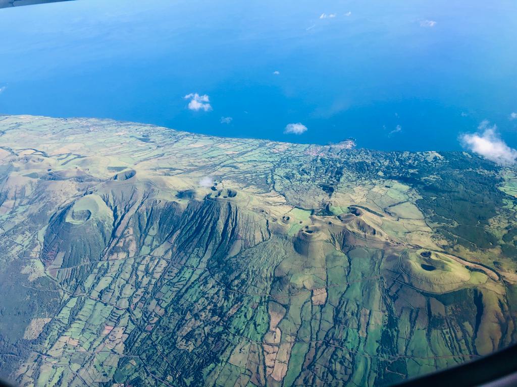
Aerial view of the volcanic ridge with aligned cinder cones in March 2022 (image: Eva K)

The linear São Jorge (San Jorge) Island is 54 km long and only 6 km wide. It was formed by fissure eruptions beginning in the eastern part of the island.

[smaller] [larger]
Typical eruption style: Effusive
São Jorge volcano eruptions: 1580, 1808

Latest nearby earthquakes

TimeMag. / DepthDistance / Location
Apr 10, 05:54 am (Azores)
1.8

0 km
20 km (12 mi) to the NW N Rosais (S. Jorge)
Info
Friday, April 19, 2024 GMT (1 quake)
Apr 18, 11:03 pm (Azores)
1.6

0 km
10 km (6.2 mi) to the W Portugal: S. Jorge
Info
Wednesday, April 10, 2024 GMT (1 quake)
Apr 10, 05:58 am (Azores)
1.6

0 km
19 km (12 mi) to the NW North Atlantic Ocean, 25 km northwest of Sao Jorge Island, Azores, Portugal
Info
Thursday, April 18, 2024 GMT (2 quakes)
Apr 18, 10:48 am (Azores)
1.5

0 km
9.3 km (5.8 mi) to the W Portugal: S. Jorge
Info
Apr 18, 04:20 am (Azores)
1.5

0 km
11 km (7 mi) to the W Portugal: S. Jorge
Info

Background

The western two-thirds of dominantly basaltic San Jorge volcano contains youthful, fissure-fed lava flows resembling those on neighboring Pico Island. Subaerial lava flows issued from three locations above the south-central coast during 1580, producing lava flows that reached the sea.
In 1808 a series of explosions took place from vents along the south-central crest of the island; one of these fed a lava flow that also reached the southern coast. Submarine eruptions were reported on several occasions from vents off the southern and SW coasts.
----------------------
Source: Smithsonian GVP

Latest satellite images

saojorge satellite image sat1saojorge satellite image sat2
Wed, 20 Jul 2022, 14:00

Sao Jorge volcano (Azores) - Smithsonian / USGS Weekly Volcanic Activity Report for 13 July-19 July 2022 (Continuing Activity)

A seismic swarm at São Jorge began at 1605 on 19 March along a WNW-ESE fissure system stretching from Ponta dos Rosais to Norte Pequeno - Silveira. The seismic data as well as deformation data indicated a magmatic intrusion, though by early April no significant deformation was detected. The frequency of earthquakes had decreased in late May-early June, leading CIVISA to lower the Alert Level to V3 (on a scale of V0-V6) on 8 June. ... Read all
Thu, 14 Jul 2022, 10:00

Sao Jorge volcano (Azores) - Smithsonian / USGS Weekly Volcanic Activity Report for 13 July-19 July 2022 (Continuing Activity)

A seismic swarm at São Jorge began at 1605 on 19 March along a WNW-ESE fissure system stretching from Ponta dos Rosais to Norte Pequeno - Silveira. The seismic data as well as deformation data indicated a magmatic intrusion, though by early April no significant deformation was detected. The frequency of earthquakes had decreased in late May-early June, leading CIVISA to lower the Alert Level to V3 (on a scale of V0-V6) on 8 June. ... Read all

On this page:

Try our free app!
Volcanoes & Earthquakes - new app for Android
Android | iOS version

More on VolcanoDiscovery

Why is there advertising on this site?

Support us - Help us upgrade our services!

We truly love working to bring you the latest volcano and earthquake data from around the world. Maintaining our website and our free apps does require, however, considerable time and resources.
We need financing to increase hard- and software capacity as well as support our editor team. We're aiming to achieve uninterrupted service wherever an earthquake or volcano eruption unfolds, and your donations can make it happen! Every donation will be highly appreciated. If you find the information useful and would like to support our team in integrating further features, write great content, and in upgrading our soft- and hardware, please make a donation (PayPal or Online credit card payment).

Planned features:Thanks to your past donations, these features have been added recently:
Download and Upgrade the Volcanoes & Earthquakes app to get one of the fastest seismic and volcano alerts online:
Android | IOS
Thank you!
Sources: VolcanoDiscovery / VolcanoAdventures and other sources as noted.
Use of material: Most text and images on our websites are owned by us. Re-use is generally not permitted without authorization. Contact us for licensing rights.
Volcanoes & Earthquakes
VolcanoDiscovery Home
Volcanoes | Earthquakes | Photos | Volcano News | App
Adventure & Study Travel
Tours to Volcanoes and Volcanic Areas: walking tours, photo tours, study tours
Tours & Dates | FAQ | About us
Get our newsletter!
Company info
Contact | Legal info | Terms & conditions
Follow us
Follow us on facebook Follow us on Instagram Follow us on Twitter Visit our Youtube channel
EN | DE | EL | ES | FR | IT | RU
VolcanoDiscovery GmbH, Germany, Reg. nr.: HRB 103744, EU Tax Id: DE 297 465 123 owned and created by
Dr. Tom Pfeiffer, volcanologist, volcano photographer, tour organizer member of
IAVCEI
IAVCEI
Vulkanologische Gesellschaft
Volcanological Society
Ecotourism Greece
Ecotourism Greece
RUV insurance
Insured by R+V
VolcanoDiscovery © 2004- All Rights Reserved | Privacy - Cookie Settings