Contact | RSS | EN | DE | EL | ES | FR | IT | RU

Volcanoes of Japan (275)

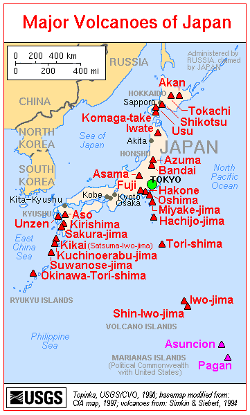
Japan has over 100 active volcanoes, more than almost any other country and accounts alone for about 10 % of all active volcanoes in the world. The volcanoes belong to the Pacific Ring of Fire, caused by subduction zones of the Pacific plate beneath continental and other oceanic plates along its margins.
Japan's volcanic arcs and tectonic setting
Japan is located at the junction of 4 tectonic plates - the Pacific, Philippine, Eurasian and North American plates, and its volcanoes are mainly located on 5 subduction-zone related volcanic arcs where the Pacific Plate descends under the North American Plate along the Kuril Trench and the Japan Trench and underneath the Philippine Sea Plate along the Izu-Bonin Trench. The Philippine Plate itself subducts beneath the Eurasian Plate at the western end, forming the Ryukyu Trench. The principal resulting volcanic ars are:
- Ryukyu Arc and Southwest Honshu Arcs in the south (Philippine plate subducting beneath between the Eurasian Plate),
- Izu-Bonin-Mariana Arc (subduction of Pacific plate beneath Philippine plate)
- Northeast Honshu and Kurile Arc in the north (subduction of Pacific plate beneath the N-American plate)
(more info: www.glgarcs.net/intro/subduction.html)

Besides intense volcanic activity, Japan is one of the places in the world most affected by frequent, and sometimes devastatingly large earthquakes. Its oceanic setting makes it vulnerable for tsunamis as well, as the tragedy of the 11 March 2011 8.9 earthquake and tsunami terrifyingly illustrated.

Record in historically documented eruptions
Japan's first documented historical eruption was from Aso volcano in 553 AD , the year after Buddhism was introduced from Korea. It holds a record in the number of historically documented eruptions.
Japan's largest historical eruption (Towada, 915 AD), 17 Japanese volcanoes had been documented in eruption, more than the rest of the world combined (including 10 in Europe).

Ata caldera

Hokkaido (52 volcanoes)

Akaigawa | Akan | Birao | Chubetsu | Daisetsu | E-san | E-san Maru-yama | Hakodate-yama | Horohoro-Tokushumbetsu | Kariba | Komaga-take | Kumaneshiri | Kutcharo | Kuttara | Mashu | Musa | Nigorigawa | Nipesotsu-Maruyama | Niseikaushuppe | Niseko | Okushiri-Katsuma-yama | Onnebetsu | Orofure-Raiba | Oshima Maru-yama | Oshima-Ko-jima | Oshima-Oshima | Raiden | Rausu | Rishiri | Samakkenupuri | Sapporo | Shari | Shiitokoro | Shikaribetsu | Shikaribetsu Group | Shikotsu | Shiretoko | Shiretoko-Iozan | Shiribetsu | Soranuma | Tenchozan | Tengu-Hirayama | Tokachi | Tokachi-Eboshi | Tokachi-Mitsumata | Tomuraushi Volcanic Group | Unabetsu | Usu | Washibetsu | Yokotsu | Yotei | Zenikame

Honshu (140 volcanoes)

Abu | Adachi | Adatara | Aizu Nunobiki | Akagi | Akita-Komagatake | Akita-Yake-yama | Aonoyama | Aoso | Asakusa | Asama | Ashitaka | Ayame-daira | Azuma | Azumayasan | Bandai | Bishamon-dake | Chojagahara | Chokai | Daikon-jima | Dainichi-yama | Dainichiga-take | Daira-Komaga-take | Daisen | Daito | Daruma | Dorobu | Eboshi | Eboshi-Washigatake | Funagata | Futamata | Gankyoji | Ganto-Kamuro | Gassan | Hachimantai | Hakkoda | Hakone | Haku-san | Hanamagari | Haruna | Hijiori | Hiuchi | Hodakadake | Hotaka | Iiji | Iizuna | Iwaki | Iwate | Izu-Tobu | Jaishi | Kaminoroka | Kamitakara | Kannabe | Kanpu | Kayo | Kenashi | Kinunuma-Nenakusa | Kirigamine | Kita Yatsugatake | Kobinai | Komochi-Onoko | Kurikoma | Kurofuji | Kurohime | Kusatsu-Shirane | Kyoga-take | Madarao | Masugata | Megata | Midagahara | Minakami | Momisawa-dake | Moriyoshi | Motodori | Mt Fuji | Mukaimachi | Mutsu-Hiuchi-dake | Mutsure-jima | Myoko | Naeba | Nanashigure | Nantai | Nanzaki | Narugo | Nasu | Nekoma | Niigata-Yake-yama | Nikko-Shirane | Norikura | Noro | Numanokami | Numazawa | Nyoho-Akanagi | Nyuto-Takakura | Oetaka-yama | Ogino-Sen | Oki-Dogo | Okiura | Omanago | Omeshi-dake | Onikobe | Ontake-san | Osore-yama | Ryohaku Maru-yama | Sanbe | Sekita | Sengoku | Shiga | Shikuma | Shirataka | Shirouma-Oike | Sukai-Kesemaru | Sumon | Sunagohara | Taga | Takahara | Takamatsu | Takara | Takayashiro | Tamagawa | Tanaba | Tashiro | Tazawa | Tenshi | Tokuyama-Mitake | Tomuro | Torikabuto | Towada | Tsuruta | Ueno | Usami | Utsukushigahara | Washiba-Kumonotaira | Yake-dake | Yakeishi | Yatsugatake | Yokote | Yuga-mine | Yugawara | Zao

Izu Islands (21 volcanoes)

Aoga-shima | Doyo | Hachijo-jima | Inamba-jima | Kozushima | Kurose Hole | Mikura Seamount | Mikura-jima | Miyake-shima | Mokuyo | Myojin Knoll | Myojinsho | Nii-jima | Onoharajima | Oshima | Sofugan | Suiyo | Sumisujima | To-shima | Tori-shima | Udonejima

Kyushu (26 volcanoes)

Aso | Ata caldera | Fukue | Futago | Hane-yama | Hime-shima Volcanic Group | Hohi | Hokusatsu | Ibusuku | Iki Volcanic Group | Imuta | Kakuto | Kinpo | Kirishima | Kuju | Kurose | Ojikajima | Sakurajima | Satsuma Maru-yama | Sendai | Sone | Sumiyoshi-ike | Taradake | Tsurumi | Unzen | Yabakei

Ryukyu Islands (14 volcanoes)

Akuseki-jima | Gajajima | Io-Torishima | Iriomote-jima | Kikai | Kobi-sho | Kogaja-jima | Kuchinoerabu-jima | Kuchinoshima | Kuroshima | Nakano-shima | Suwanose-jima | Tokara Hirase | Yokoate-jima

Volcano Islands (19 volcanoes)

Daikoku | Fukujin | Fukutoku-Okanoba | Getsuyo Seamount | Iwo-jima | Kaikata | Kaitoku | Kasuga | Kayo Seamount | Kinyo Seamount | Kita-Fukutokutai | Kita-Ioto | Minami Kasuga | Minami-Hiyoshi | Nichiyo Seamount | Nikko | Nishino-shima | NW Eifuku | unnamed
[smaller] [bigger]

Volcano list

Ata caldera

(caldera 924 m / 3031 ft)
Ata is one of the major active caldera systems of Kyushu, located south of the Kagoshima Bay. It had a massive "super-volcano"-style eruption 40,000 years ago, and contains the active Ibusuki volcanic field as well as famous Kaimondake stratovolcano towering above the southern ti... [more info]

Useful Links:

News & updates
Wed, 3 Apr 2024, 18:00

Suwanosejima volcano (Ryukyu Islands, Japan) - Smithsonian / USGS Weekly Volcanic Activity Report for 27 March-2 April 2024 (Continuing Activity)

JMA reported that the eruption at Suwanosejima's Ontake Crater continued during 25 March-1 April. Crater incandescence was observed in webcam images nightly. No explosions were detected but eruption plumes rose as high as 500 m above the crater rim. ... Read all
Wed, 3 Apr 2024, 18:00

Kuchinoerabujima volcano (Ryukyu Islands, Japan) - Smithsonian / USGS Weekly Volcanic Activity Report for 27 March-2 April 2024 (Continuing Activity)

JMA reported that the number of shallow volcanic earthquakes at Kuchinoerabujima increased during June and July 2023, fluctuated at elevated levels, began to decrease in mid-January 2024, and continued to decrease through March. The epicenters were mainly located near Furudake Crater, with some located near Shindake Crater (just N of Furudake). Sulfur dioxide emissions shared a similar pattern with increases starting in July 2023, peaks of 200-400 tons per day (t/d) during August-September, and a gradual decrease to less than 100 t/d by 18 March 2024. ... Read all
Wed, 3 Apr 2024, 18:00

Aira volcano (Kyushu, Japan) - Smithsonian / USGS Weekly Volcanic Activity Report for 27 March-2 April 2024 (Continuing Activity)

JMA reported ongoing eruptive activity at Minamidake Crater (Aira Caldera's Sakurajima volcano) during 25 March-1 April with nighttime crater incandescence. Very small eruptive events occasionally occurred during the week. During an overflight on 27 March emissions obscured views of Minamidake Crater, though observers noted no changes at the either the Showa Crater geothermal area or around the flanks of both craters. ... Read all
Map of volcanoes in Japan (USGS)
Try our free app!
Volcanoes & Earthquakes - new app for Android
Android | iOS version

More on VolcanoDiscovery

Why is there advertising on this site?

Support us - Help us upgrade our services!

We truly love working to bring you the latest volcano and earthquake data from around the world. Maintaining our website and our free apps does require, however, considerable time and resources.
We need financing to increase hard- and software capacity as well as support our editor team. We're aiming to achieve uninterrupted service wherever an earthquake or volcano eruption unfolds, and your donations can make it happen! Every donation will be highly appreciated. If you find the information useful and would like to support our team in integrating further features, write great content, and in upgrading our soft- and hardware, please make a donation (PayPal or Online credit card payment).

Planned features:Thanks to your past donations, these features have been added recently:
Download and Upgrade the Volcanoes & Earthquakes app to get one of the fastest seismic and volcano alerts online:
Android | IOS
Thank you!
Sources: VolcanoDiscovery / VolcanoAdventures and other sources as noted.
Use of material: Most text and images on our websites are owned by us. Re-use is generally not permitted without authorization. Contact us for licensing rights.
Volcanoes & Earthquakes
VolcanoDiscovery Home
Volcanoes | Earthquakes | Photos | Volcano News | App
Adventure & Study Travel
Tours to Volcanoes and Volcanic Areas: walking tours, photo tours, study tours
Tours & Dates | FAQ | About us
Get our newsletter!
Company info
Contact | Legal info | Terms & conditions
Follow us
Follow us on facebook Follow us on Instagram Follow us on Twitter Visit our Youtube channel
EN | DE | EL | ES | FR | IT | RU
VolcanoDiscovery GmbH, Germany, Reg. nr.: HRB 103744, EU Tax Id: DE 297 465 123 owned and created by
Dr. Tom Pfeiffer, volcanologist, volcano photographer, tour organizer member of
IAVCEI
IAVCEI
Vulkanologische Gesellschaft
Volcanological Society
Ecotourism Greece
Ecotourism Greece
RUV insurance
Insured by R+V
VolcanoDiscovery © 2004- All Rights Reserved | Privacy - Cookie Settings