Contact | RSS | EN | DE | EL | ES | FR | IT | RU

Bardarbunga Volcano

Updated: Apr 24, 2024 09:26 GMT -
Stratovolcano approx. 2000 m / ca. 6,560 ft
Central Iceland, 64.63°N / -17.53°W
Current status: normal or dormant (1 out of 5)
Last update: 22 Apr 2024 (M 5.4 quake yesterday)
Lava fountains from the Holuhraun fissure eruption August 2014

Bardarbunga (Bárðarbunga) is a large central volcano lying underneath Iceland's 500-m thick Vatnajokull glacier in the center of the country. It is located at the junction between the eastern and northern volcanic rift zones in the area where the present-day center of the mantle hot spot beneath Iceland is thought to be.
Bardarbunga has had about 300-400 eruptions during the past 10,000 years which includes only 23 eruptions historic times (approx the past 1000 years), i.e. it seems to erupt currently at rates of approx. twice per century, the last one having occurred in 1910. A massive explosive-effusive eruption (VEI 6) in 1477 resulted in a large ash and pumice fall-out deposit.
Approx 8600 years ago, Bardarbunga produced the largest known lava flow during the past 10,000 years on earth (more than 21 cubic kilometers of volume). The lava was erupted from the Veidivötn fissure system and traveled more than 100 km to the south coast.

[smaller] [larger]
Typical eruption style: Large effusive eruptions, some explosive activity.
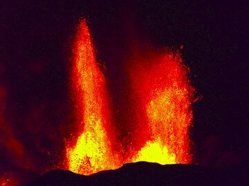
Bardarbunga volcano eruptions: 1080(?), 1159(?), ca. 1210, ca. 1270, ca. 1350, ca. 1410(?), 1477 (very large effusive-explosive eruption), 1697, 1702, 1706, 1712, 1716, 1717, 1720, 1726, 1729, 1739, 1750, 1766, 1769, 1797, 1807(?), 1862-64, 1872(?), 1902-03, 1910, 2014-15 (Holuhraun fissure eruption)

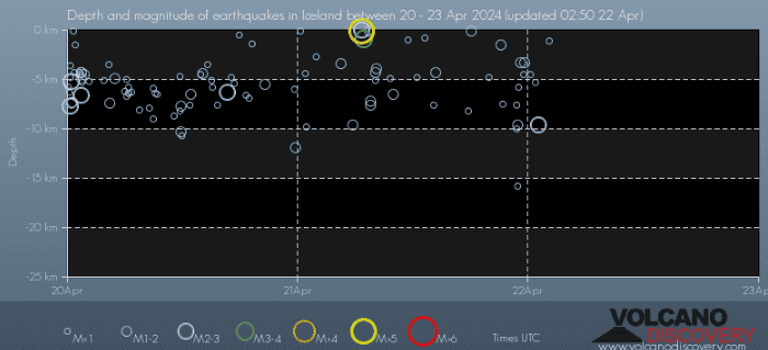
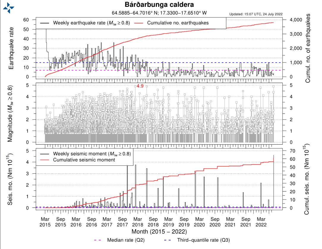
Latest nearby earthquakes

TimeMag. / DepthDistance / Location
Apr 21, 06:53 am (Reykjavik)
3.0

0.9 km
6.2 km (3.8 mi) to the NE 5.2 km NE of Bárðarbunga  I FELT IT
Info
Apr 21, 06:37 am (Reykjavik)
5.4

0.1 km
8.1 km (5 mi) to the E 7.7 km E of Bárðarbunga  I FELT IT Info
Saturday, April 20, 2024 GMT (2 quakes)
Apr 20, 04:40 pm (Reykjavik)
2.2

6.3 km
2.7 km N of Bárðarbunga
Info
Apr 20, 01:25 am (Reykjavik)
2.5

6.6 km
5.4 km (3.4 mi) to the N 4.2 km N of Bárðarbunga
Info
Thursday, April 11, 2024 GMT (1 quake)
Apr 11, 12:42 am (Reykjavik)
2.3

6.3 km
8.9 km NNW of Grímsfjall
Info
Wednesday, April 10, 2024 GMT (1 quake)
Apr 10, 08:09 pm (Reykjavik)
3.0

1.8 km
7.6 km (4.7 mi) to the E 7.6 km E of Bárðarbunga
Info

Background

The volcano is hidden beneath the northwestern part of the Vatnajökull glacier, and contains a 700-m-deep caldera that is hidden beneath ice and has extensive flank fissures, from where eruptions have taken place: the Veidivötn fissure extends for over 100 km to the SW, almost reaching Torfajökull volcano, while the Trollagigar fissure extends 50 km to the NE touching Askja volcano.

A major risk from Bárdarbunga are jökulhlaups (glacier-outburst floods), that can be hazardous for areas in all directions around Bárdarbunga.

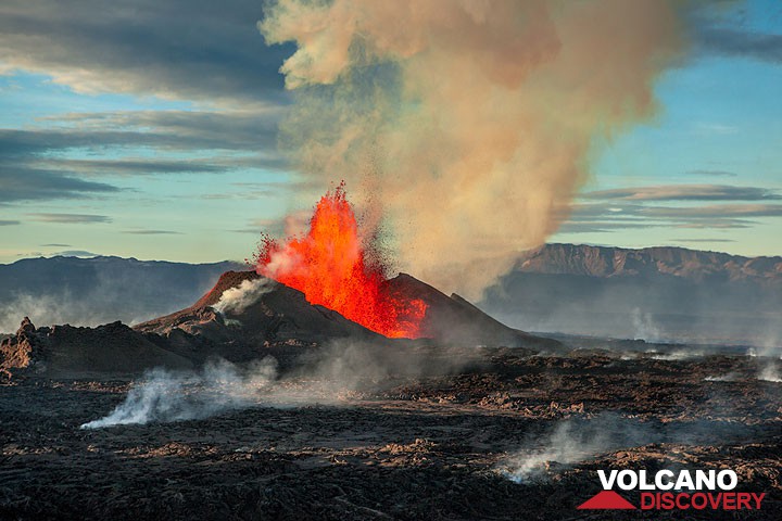
Bardarbunga Volcano Photos
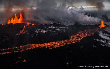
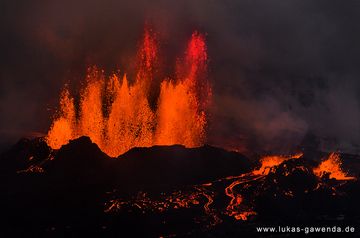
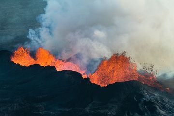
Latest satellite images

bardarbunga satellite image sat1bardarbunga satellite image sat2

Mon, 22 Apr 2024, 03:20

Bardarbunga volcano (Iceland): M 5.4 quake yesterday

Depth and magnitude vs time plot showing the M 5.4 quake in the vicinity of Bardarbunga volcano (image: VolcanoDiscovery)
A new seismic activity occurred beneath the volcano recently. ... Read all
Mon, 25 Jul 2022, 23:14

Bardarbunga volcano (Iceland): M 4.4 and 4.9 quakes, inflation continues

Seismic development from 2015 until so far (image: Kristín Jónsdóttir/twitter)
Kristín Jónsdóttir from the Icelandic Met Office reported on her Twitter account that two volcano-tectonic earthquakes with magnitude M 4.9 and M 4.4 occurred beneath the Bárðarbunga caldera. Read all

On this page:

Try our free app!
Volcanoes & Earthquakes - new app for Android
Android | iOS version

More on VolcanoDiscovery

Why is there advertising on this site?

Support us - Help us upgrade our services!

We truly love working to bring you the latest volcano and earthquake data from around the world. Maintaining our website and our free apps does require, however, considerable time and resources.
We need financing to increase hard- and software capacity as well as support our editor team. We're aiming to achieve uninterrupted service wherever an earthquake or volcano eruption unfolds, and your donations can make it happen! Every donation will be highly appreciated. If you find the information useful and would like to support our team in integrating further features, write great content, and in upgrading our soft- and hardware, please make a donation (PayPal or Online credit card payment).

Planned features:Thanks to your past donations, these features have been added recently:
Download and Upgrade the Volcanoes & Earthquakes app to get one of the fastest seismic and volcano alerts online:
Android | IOS
Thank you!
Sources: VolcanoDiscovery / VolcanoAdventures and other sources as noted.
Use of material: Most text and images on our websites are owned by us. Re-use is generally not permitted without authorization. Contact us for licensing rights.
Volcanoes & Earthquakes
VolcanoDiscovery Home
Volcanoes | Earthquakes | Photos | Volcano News | App
Adventure & Study Travel
Tours to Volcanoes and Volcanic Areas: walking tours, photo tours, study tours
Tours & Dates | FAQ | About us
Get our newsletter!
Company info
Contact | Legal info | Terms & conditions
Follow us
Follow us on facebook Follow us on Instagram Follow us on Twitter Visit our Youtube channel
EN | DE | EL | ES | FR | IT | RU
VolcanoDiscovery GmbH, Germany, Reg. nr.: HRB 103744, EU Tax Id: DE 297 465 123 owned and created by
Dr. Tom Pfeiffer, volcanologist, volcano photographer, tour organizer member of
IAVCEI
IAVCEI
Vulkanologische Gesellschaft
Volcanological Society
Ecotourism Greece
Ecotourism Greece
RUV insurance
Insured by R+V
VolcanoDiscovery © 2004- All Rights Reserved | Privacy - Cookie Settings