Bakening Volcano
Updated: 19. Apr. 2024 19:41 GMT -
Stratovolcano 2278 m / 7,474 ft
Kamchatka, Russia, 53.91°N / 158.07°E
Aktueller Status: normal / ruhend (1 von 5)
Kamchatka, Russia, 53.91°N / 158.07°E
Aktueller Status: normal / ruhend (1 von 5)
[smaller] [larger]
Ausbrüche des Bakening: 550 BC
Letzte Erdbeben in der Nähe
| Uhrzeit | Mag. / Tiefe | Entfernung / Ort | |||
Beschreibung
Bakening volcano (also known as Bakenin) lies well west of the eastern volcanic range of Kamchatka, at the head of the Srednyaya Avacha River, about 100 km NNW of Petropavlovsk. Most of the volcano is of Pleistocene age, and subglacial rhyodacitic tuyas are located on the NW flanks. The 2278-m-high andesitic stratovolcano has dacitic lava domes at its north and NE base, the latest of which (Novo Bakening) formed about 9000-10,000 years ago. A large horseshoe-shaped depression on the SE flank was the source of a large debris avalanche about 8000-8500 years ago that traveled 11 km to the east and south. The avalanche, which dammed drainages forming two lakes NE and east of the volcano, was followed by an explosive eruption and a block-and-ash flow. Several late-Pleistocene to Holocene cinder cones are located on the northern-to-southern flanks of the volcano. The latest dated activity consisted of the construction of a cinder cone at the western foot of the volcano about 2500 year ago.---
Smithsonian / GVP volcano information
Bakening Volcano Photos
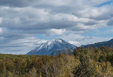
16. September: Transfertag. Am Nachmittag erhalten wir auf der Rückfahrt nach Elizovo einen kurzen Blick auf den Vulkan Bakening. (Photo: Tom Pfeiffer)
Latest satellite images