Kontakt | RSS | EN | DE | EL | ES | FR | IT | RU

Cumbal Volcano

Updated: 23. Apr. 2024 07:26 GMT -
stratovolcano 4764 m / 15,630 feet
Kolumbien, 0.95°N / -77.87°W
Aktueller Status: normal / ruhend (1 von 5)
Last update: 15 Dez 2021

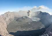
Cumbal volcano is an active glacier-capped stratovolcano in SW Colombia, located 25 km SW of Azufral volcano and 5.5 km NE of the town of Cumbal - Pueblo.
Cumbal is the southernmost active volcano of Colombia that has erupted in historic times.
A young lava dome occupies the 250-m-wide summit crater, and eruptions from the upper east flank produced a 6-km-long lava field. Thermal springs occur on the SE flanks.

[smaller] [larger]
Typische Aktivität: effusive, mildly explosive
Ausbrüche des Cumbal: 1926, 1877

Letzte Erdbeben in der Nähe

No recent earthquakes
UhrzeitMag. / TiefeEntfernung / Ort

Beschreibung

Cumbal volcano is elongated in a NE-SW direction and composed primarily of andesitic-dacitic lava flows, including many geologically young ones. Over time, the active vents seem to have migrated SW-wards:
The 2 active craters, the main crater on the NE side and Mundo Nuevo crater on the SW side have active fumaroles and sulphur deposits and built the summit ridge, while the oldest vents are located NNE of Cumbal and Mundo Nuevo craters.

Ausbrüche des Vulkans Cumbal


1988 volcanic unrest
Seismic unrest and an increase in fumarolic activity occurred in 1988, simultaneously with nearby Galeras volcano.

Latest satellite images

Cumbal satellite image sat1Cumbal satellite image sat2
Fr, 30. Mai 2014, 09:55

Cumbal volcano (Colombia) activity update

Seismic unrest continues at the volcano, still on alert status Yellow, with little variation over the past months. The Pasto volcano observatory reported a 50% increase in earthquakes during the past week. Read all
Mi, 22. Jan 2014, 09:02

Cumbal volcano (Colombia) activity update: continuing small earthquake swarms

Seismic unrest at weak energy levels continues. 5 small earthquake swarms were recorded over the past week, the most prominent having 213 events up to a maximum of magnitude 1.9 during 5 hours on 19 Jan. Most quakes are associated with rock fracturing at shallow depths (3 km) beneath the La Plazuela crater. Pasto reports no unusual surface activity at the volcano. ... Read all

Auf dieser Seite:

App herunterladen
Volcanoes & Earthquakes - new app for Android
Android | iOS-Version

Mehr auf VolcanoDiscovery

Warum gibt es Werbung auf dieser Seite?

Unterstützen Sie unsere Arbeit!

Diese Webseite und die dazugehörigen Apps und Tools instandzuhalten und kostenlos Nachrichten zu Vulkanen, Erdbeben und anderen Themen bereitzustellen, verschlingt enorm viel Zeit und auch Geld.
Wenn Sie die Infos mögen und uns in der Arbeit dazu unterstützen wollen, würden wir uns über eine Spende (über PayPal oder mit Kreditkarte) sehr freuen.
Online Zahlung (Kreditkarte)
Damit können wir Ihnen auch in Zukunft neue Features entwickeln und Bestehende laufend verbessern.Vielen Dank!
Sources: VolcanoDiscovery / VolcanoAdventures and other sources as noted.
Use of material: Most text and images on our websites are owned by us. Re-use is generally not permitted without authorization. Contact us for licensing rights.
Volcanoes & Earthquakes
VolcanoDiscovery Home
Vulkane | Erdbeben | Fotos | News | App
Adventure & Study Travel
Reisen zu Vulkanen und Vulkangebieten: Wanderreisen, Studienreisen, Fotoreisen
Tours & Dates | FAQ | About us
Get our newsletter!
Company info
Kontakt | Impressum | AGB
Follow us
Follow us on facebook Follow us on Instagram Follow us on Twitter Visit our Youtube channel
EN | DE | EL | ES | FR | IT | RU
VolcanoDiscovery GmbH, Germany, Reg. nr.: HRB 103744, EU Tax Id: DE 297 465 123 owned and created by
Dr. Tom Pfeiffer, volcanologist, volcano photographer, tour organizer member of
IAVCEI
IAVCEI
Vulkanologische Gesellschaft
Volcanological Society
Ecotourism Greece
Ecotourism Greece
RUV insurance
Insured by R+V
VolcanoDiscovery © 2004- All Rights Reserved | Datenschutz - Cookie Einstellungen