Kontakt | RSS | EN | DE | EL | ES | FR | IT | RU

Soufriere Hills Volcano

Updated: 25. Apr. 2024 21:07 GMT -
Stratovolcano, lava dome 915 m / 3002 ft (changing!)
Montserrat, West Indies (UK), 16.72°N / -62.18°W
Aktueller Status: normal / ruhend (1 von 5)
Last update: 13 Sep 2023 (Smithsonian / USGS Weekly Volcanic Activity Report)

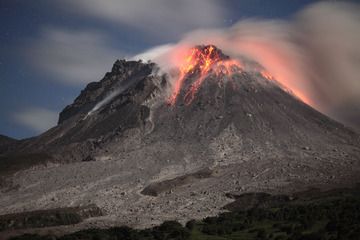
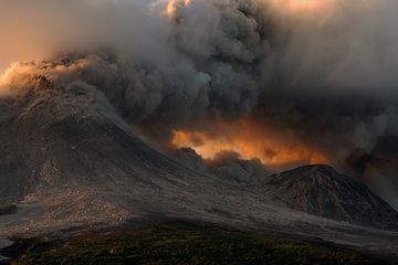
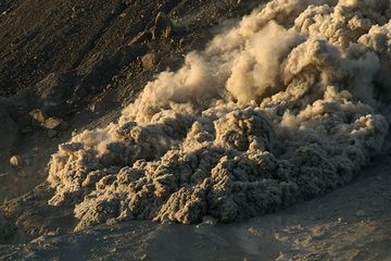
Soufrière Hills volcano is a complex stratovolcano that forms the northern half of the small Island of Montserrat in the British Lesser Antilles. After 350 years of quiet, it came back into life in 1995 and started to build a new lava dome. The eruption alternated between less or more intense phases including rapid dome growth with associated powerful vulcanian explosions and large pyroclastic flows from dome collapse.
The eruption, in particular the effects of pyroclastic flows and lahars caused by heavy rains have destroyed a large part of the island, including the capital Plymouth, and the population has been relocated to the northern part of the island and has been fighting, with the help of the UK government, to maintain life on the island.
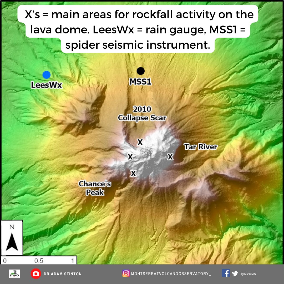
One of the world's most modern volcano observatories, the MVO, has been installed on the island and while largely unknown prior to 1995, Soufrière Hills volcano now counts as one of the best monitored active volcanoes world-wide.

[smaller] [larger]
Typische Aktivität: Explosive. Construction of lava domes.
Ausbrüche des Soufriere Hills: 2005-2013, 2004, 1995-2003
1550 ± 50 years, 1480 ± 50 years, 1180 (?), 2460 BC ± 70 years, 4050 BC (?), 8050 BC ± 2000 years

Letzte Erdbeben in der Nähe

UhrzeitMag. / TiefeEntfernung / Ort
22. Apr. 17:18 (GMT -4)
2.5

17 km
29 km östlich near Les Abymes
Info
Samstag, 13. April 2024 GMT (1 Beben)
12. Apr. 20:06 (Montserrat)
2.7

130 km
4.9 km südwestlich near Baie-Mahault
Info

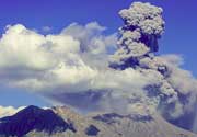
Soufriere Hills Volcano Photos

Latest satellite images

montserrat satellite image sat1montserrat satellite image sat2

Background:

Montserrat's Soufrière Hills volcano is a typical subduction volcano. Its existence is due to the subduction of the Atlantic under the Caribbean plate.


Its first historic eruption started in 1995 and is still ongoing. During this eruption, the former capital of the island, Plymouth, as well as a large sector of the southern part of the island including its former airport have been devastated by pyroclastic flows and much of it is now buried beneath a thick layer of ash and mud.


The long-term eruption consists in small-to-moderate ash eruptions accompanied by lava-dome growth and pyroclastic flows. Failed eruptions (non eruptive seismic events) had occurred at Soufriere Hills volcano in the 1890's, 1930's, and 1960's.


The complex dominantly andesitic Soufrière Hills volcano occupies the southern half of the island of Montserrat. The summit area consists primarily of a series of lava domes emplaced along an ESE-trending zone. English's Crater, a 1-km-wide crater breached widely to the east, was formed during an eruption about 4000 years ago in which the summit collapsed, producing a large submarine debris avalanche. Block-and-ash flow and surge deposits associated with dome growth predominate in flank deposits at Soufrière Hills.


With the exception of a 17th-century eruption around 1630 AD that produced the Castle Peak lava dome, no historical eruptions were recorded on Montserrat until 1995.


News:
Mi, 13. Sep 2023, 14:00

Soufriere Hills volcano (Montserrat) - Smithsonian / USGS Weekly Volcanic Activity Report for 6 September-12 September 2023 (Continuing Activity)

MVO reported that a very small increase in activity at Soufrière Hills during 1-8 September was characterized by small rockfalls coincident with volcano-tectonic earthquake activity and occasional small, low-frequency, volcanic earthquakes. The seismic network recorded 27 volcano-tectonic earthquakes spilt between two swarms recorded on 6 and 8 September. Minor rockfall activity and volcano-tectonic seismicity began at about 2100 on 7 September and was ongoing. ... Read all
Fr, 6. Mai 2022, 03:00

Soufriere Hills volcano (Montserrat, West Indies): small rockfall followed heavy rainfalls

The location of the rain gauge in relation to the lava dome (image: Montserrat Volcano Observatory)
A smaller rockfall activity occurred at the volcano starting on 28 April at 22:50 local time until 1 May. ... Read all

Auf dieser Seite:

App herunterladen
Volcanoes & Earthquakes - new app for Android
Android | iOS-Version

Mehr auf VolcanoDiscovery

Warum gibt es Werbung auf dieser Seite?

Unterstützen Sie unsere Arbeit!

Diese Webseite und die dazugehörigen Apps und Tools instandzuhalten und kostenlos Nachrichten zu Vulkanen, Erdbeben und anderen Themen bereitzustellen, verschlingt enorm viel Zeit und auch Geld.
Wenn Sie die Infos mögen und uns in der Arbeit dazu unterstützen wollen, würden wir uns über eine Spende (über PayPal oder mit Kreditkarte) sehr freuen.
Online Zahlung (Kreditkarte)
Damit können wir Ihnen auch in Zukunft neue Features entwickeln und Bestehende laufend verbessern.Vielen Dank!
Sources: VolcanoDiscovery / VolcanoAdventures and other sources as noted.
Use of material: Most text and images on our websites are owned by us. Re-use is generally not permitted without authorization. Contact us for licensing rights.
Volcanoes & Earthquakes
VolcanoDiscovery Home
Vulkane | Erdbeben | Fotos | News | App
Adventure & Study Travel
Reisen zu Vulkanen und Vulkangebieten: Wanderreisen, Studienreisen, Fotoreisen
Tours & Dates | FAQ | About us
Get our newsletter!
Company info
Kontakt | Impressum | AGB
Follow us
Follow us on facebook Follow us on Instagram Follow us on Twitter Visit our Youtube channel
EN | DE | EL | ES | FR | IT | RU
VolcanoDiscovery GmbH, Germany, Reg. nr.: HRB 103744, EU Tax Id: DE 297 465 123 owned and created by
Dr. Tom Pfeiffer, volcanologist, volcano photographer, tour organizer member of
IAVCEI
IAVCEI
Vulkanologische Gesellschaft
Volcanological Society
Ecotourism Greece
Ecotourism Greece
RUV insurance
Insured by R+V
VolcanoDiscovery © 2004- All Rights Reserved | Datenschutz - Cookie Einstellungen