Tidore Volcano
Updated: 17. Apr. 2024 21:22 GMT -
stratovolcano 1730 m / 5,676 ft
Halmahera (Indonesien), 0.66°N / 127.4°E
Aktueller Status: normal / ruhend (1 von 5)
Halmahera (Indonesien), 0.66°N / 127.4°E
Aktueller Status: normal / ruhend (1 von 5)
Tidore volcanic complex forms a conisits of 2 volcanoes, the beautiful and conical Kiematabu peak (1730 m) in the south and the lower, broad volcano of Sabale volcano in north, containing a caldera and two cinder cones. Kiematabu peak is the highest volcano of the North Maluku island chain. Maitara Island, 1 km off the NW coast, forms another volcanic edifice belonging to the same chain.
No historic activity is known from the complex.
[smaller] [larger]
Ausbrüche des Tidore: none in historic times
Letzte Erdbeben in der Nähe
| Uhrzeit | Mag. / Tiefe | Entfernung / Ort | |||
Tidore Volcano Photos
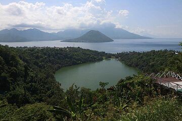
Laguna (Ngade) See und Maitara- und Tidore-Inseln, Ternate, Nord-Maluku, Indonesien (Photo: Jay Ramji)
Latest satellite images