Lihir Volcano
Provincia de Nueva Irlanda (Papúa Nueva Guinea), -3.13°S / 152.64°E
Current status: normal or dormant (1 out of 5)
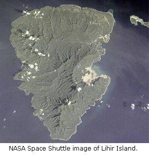
Lihir volcano forms the small Lihir Island, the largest of a group of island north of New Ireland (Papua New Guinea). It is the largest of the volcanic chain east of New Ireland. Lihir is composed of 5 overlapping basaltic stratovolcanoes, including Luise, Kinami, and Huniho. 4 young submarine volcanoes offshore Lihir Island belong to the complex as well.
Luise is the youngest volcano of Lihir and contains an elliptical 5.5 km long and 3.5 km wide caldera open to the sea, forming Luise Harbour. The caldera rises with steep walls 700 m above the sea, and its floor is covered by debris from the walls. It probably formed around 400,000 years ago.
In the center of the caldera, a strongly hydrothermally altered lava dome is present and displays extensive thermal activity along its margins.
Erupciones del volcán Lihir: none in recent times
Latest nearby earthquakes
| Fecha / Hora | Revista / Prof. | Distancia / Ubicación | |||
Background
Lihir Island has undergone recent uplift and tilting and is partly fringed by terraced marine limestone. Observed primary minerals at Lihir include amphibole, analcite, apatite, biotite, clinopyroxene, hauyne-sodalite, ilmenite, leucite, magnetite, nepheline, olivine, plagioclase, pyrrhotite, chalcopyrite and sanidine.(from: Lottermose, 1990)
Geothermal activity
The geothermal activity on Lihir island is concentrated in an area of about 15 sq km located inside the breached Luise Caldera. The activity consists of high and moderate temperature hot springs, boiling mud pools, and low temperature fumaroles with sulfur deposits. Gas vents are found along the beach and offshore from Luise Harbour on the sea floor.
Gold deposits on Lihir Island - the Ladolam hydrothermal deposit
Lihir Island has one of the youngest and largest gold deposits in the world: the Ladolam hydrothermal deposit. The Lihir gold mine extracts the deposit by open-pit mining. The deposit is estimated to contain about 1300 tons of gold. Most of the gold is contained in sulphides.
The deposit is contained in a hydrothermally-altered porphyry system with the gold hosted in volcanics, intrusives and breccias within the 4x6 km caldera of the youngest volcano of the island (Luise volcano). The near-surface, epithermal gold deposit extends to about 400 m below sea level and covers over an area of about 2 sq km. The depth of the open mine pit will be up to 200 m below sea level, and separated from the sea only by a narrow wall, posing serious challenges to construction safety and dewatering engineering.
The deep geothermal brine is estimated contains 15 parts per billion gold. The current gold flux of 24 kg per year means that the gold deposit could have formed within 55,000 years.
Sources & further information:
- Smithsonian / GVP volcano information
- B.G. Lottermose (1990) "Rare-earth element and heavy-metal behaviour associated with the epithermal gold deposit on Lihir Island, Papua New Guinea", Journal of Volcanology and Geothermal Research,Volume 40, Issue 4, Pages 269-289
- Stuart F. Simmons, and Kevin L. Brown (2006) "Gold in Magmatic Hydrothermal Solutions and the Rapid Formation of a Giant Ore Deposit", Science, Vol. 314 no. 5797, pp. 288-291
- Lihir Gold Mine
Latest satellite images