Contact | RSS | EN | DE | EL | ES | FR | IT | RU

Turrialba Volcano

Updated: 24 abr. 2024 23:30 GMT -
Stratovolcano 3340 m (10,958 ft)
Costa Rica, 10.03°N / -83.77°W
Current status: normal or dormant (1 out of 5)
Last update: 20 jul 2022 (Smithsonian / USGS Weekly Volcanic Activity Report)
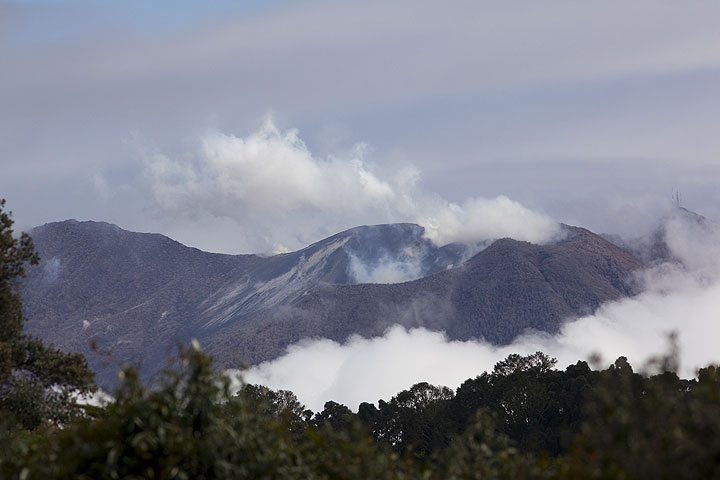
Turrialba volcano seen from Irazu

Turrialba (3340 m) is the easternmost of Costa Rica's active volcanoes. It is a large stratovolcano with a complex of 3 summit craters and its flanks mostly covered by farmland and forest. vegetation. After its previous eruption in 1866, signs of unrest started in 2006 and new phreatic activity began on Jan 4, 2010.

[smaller] [larger]
Typical eruption style: Explosive.
Erupciones del volcán Turrialba: 1723(?), 1847(?), 1853, 1855, 1861(?), 1864-65, 1866, 2010 (Jan 4) - ongoing

Latest nearby earthquakes

Fecha / HoraRevista / Prof.Distancia / Ubicación
15 abr 23:43 (Costa Rica)
2.6

4 km
12 km al noreste Costa Rica: 8 km al Oeste de Alegria, Siquirres.
Más
sábado, 13 abril 2024 GMT (1 sismo)
13 abr 11:56 (Costa Rica)
2.3

4 km
Costa Rica: 4 km al Este de Orosi, Paraiso, Cartago.
Más
viernes, 12 abril 2024 GMT (2 sismos)
12 abr 02:37 (Costa Rica)
2.9

4 km
8.5 km al sur Costa Rica: 4 km al Norte de Capellades, Alvarado.
Más
12 abr 01:37 (Costa Rica)
2.6

3 km
0.3 km al este Costa Rica: 8 km al Norte de Santa Cruz, Turrialba.
Más
jueves, 11 abril 2024 GMT (1 sismo)
11 abr 03:04 (Costa Rica)
2.7

8 km
30 km al suroeste Costa Rica: 3 km al Oeste de Orosi, Paraiso, Cartago.
Más

Background

Turrialba is the easternmost of Costa Rica's active volcanoes and a large vegetated basaltic-to-dacitic stratovolcano. It is located opposite Irazú volcano, both being separated by a broad saddle.
Together with Irazú, Turrialba is one of Costa Rica's largest volcanoes. During the past 3500 years in prehistoric times, it has had at least 5 larger explosive eruptions. The top of Turrialba has 3 craters at the upper SW end of a broad 800 x 2200 m wide summit depression breached to the NE.
Eruptions from Turrialba occurred mostly from the summit craters, although two flank cones are found on the SW flank. During the 19th century, a few eruptions occurred that produced pyroclastic flows. Since an eruption in 1866 and until 2006, Turrialba was quiescent, but showed strong fumarolic activity at the central craters.
Since 2006, increased fumarolic and seismic activity were noted. On Jan 4, 2010, two new vents that later merged into a fissure aligned along the tectonic trend of the summit area opened in its western crater and started to erupt large amounts of sulphur dioxide gas and occasional lithic ash. This phreatic activity was accompanied by strong tremors and continued for a few days, but declined since Jan 8. Ash fall in the surroundings of the volcano and acid rain caused damage to agriculture and prompted evacuation of about 30 inhabitants living in the immediate vicinity of the volcano.

Latest satellite images

Turrialba satellite image sat1Turrialba satellite image sat2

mié, 20 jul 2022, 14:00

Turrialba volcano (Costa Rica) - Smithsonian / USGS Weekly Volcanic Activity Report for 13 July-19 July 2022 (New Activity / Unrest)

OVSICORI-UNA reported that at 0749 on 17 July a brief ash emission from Turrialba rose 200 m above the crater and drifted SW. Minor amounts of ash fell in Irazú Volcano National Park. ... Read all
jue, 14 jul 2022, 10:00

Turrialba volcano (Costa Rica) - Smithsonian / USGS Weekly Volcanic Activity Report for 13 July-19 July 2022 (New Activity / Unrest)

OVSICORI-UNA reported that at 0749 on 17 July a brief ash emission from Turrialba rose 200 m above the crater and drifted SW. Minor amounts of ash fell in Irazú Volcano National Park. ... Read all

En esta página:

Try our free app!
Volcanoes & Earthquakes - new app for Android
Android | iOS version

Más en VolcanoDiscovery

Why is there advertising on this site?

Support us - Help us upgrade our services!

We truly love working to bring you the latest volcano and earthquake data from around the world. Maintaining our website and our free apps does require, however, considerable time and resources.
We need financing to increase hard- and software capacity as well as support our editor team. We're aiming to achieve uninterrupted service wherever an earthquake or volcano eruption unfolds, and your donations can make it happen! Every donation will be highly appreciated. If you find the information useful and would like to support our team in integrating further features, write great content, and in upgrading our soft- and hardware, please make a donation (PayPal or Online credit card payment).

Planned features:Thanks to your past donations, these features have been added recently:
Download and Upgrade the Volcanoes & Earthquakes app to get one of the fastest seismic and volcano alerts online:
Android | IOS
Thank you!
Sources: VolcanoDiscovery / VolcanoAdventures and other sources as noted.
Use of material: Most text and images on our websites are owned by us. Re-use is generally not permitted without authorization. Contact us for licensing rights.
Volcanoes & Earthquakes
VolcanoDiscovery Home
Volcanes | Sismos | Fotos | News | App
Adventure & Study Travel
Tours to Volcanoes and Volcanic Areas: walking tours, photo tours, study tours
Tours & Dates | FAQ | About us
Get our newsletter!
Company info
Contact | Legal info | Terms & conditions
Follow us
Follow us on facebook Follow us on Instagram Follow us on Twitter Visit our Youtube channel
EN | DE | EL | ES | FR | IT | RU
VolcanoDiscovery GmbH, Germany, Reg. nr.: HRB 103744, EU Tax Id: DE 297 465 123 owned and created by
Dr. Tom Pfeiffer, volcanologist, volcano photographer, tour organizer member of
IAVCEI
IAVCEI
Vulkanologische Gesellschaft
Volcanological Society
Ecotourism Greece
Ecotourism Greece
RUV insurance
Insured by R+V
VolcanoDiscovery © 2004- All Rights Reserved | Privacy - Cookie Settings