(volcanic field 2217 m / 7,274 ft)
Alligator Lake in southern Yukon, Canada, is a group of basaltic cones and lava flows (the Miles Canyon basalts). It is located at the northern extremity of the Stikine volcanic belt, 30 km southwest of the capital city Whitehorse.
The field contains 2 cinder cones on top ... [
plus d'info]
(cinder cones 1880 m / 6,168 ft)
Atlin is a group of young cinder cones and lava flows on the Teslin Plateau east of Lake Atlin in western British Columbia, Canada. The largest cone is 1880-m-high Ruby Mountain (named for the brilliantly colored tephra deposits), which has been partially eroded by glaciation. [
plus d'info]
(volcanic field 2500 m / 8,202 ft)
The Bridge River Cones are a field of small basaltic cinder cones in SW British Columbia, Canda. The youngest activity from this volcanic area could be less than 1500 years old. [
plus d'info]
(cinder cone 335 m / 1,099 ft)
Crow Lagoon is a little-known volcanic center located north of Prince Rupert, British Columbia, Canada. There are thick layers of basaltic scoria from eruptions less than 10,000 years old.
Crow Lagoon is one of the top 10 volcanoes in Canada with recent seismic activity. Th... [
plus d'info]
(stratovolcano 2786 m / 9,140 ft)
Mount Edziza in northwestern British Columbia. (photo: Wikimedia Commons)
Mount Ediziza in NW British Columbia, Canada is a large, complex stratovolcano about 1 million years old forming the most recently active of a group of overlapping basaltic shields, lava domes, flows, and central stratovolcanoes. Mount Edziza contains a 2-km-wide, ice-filled summ... [
plus d'info]
(volcanic field 1239 m / 4,065 ft)
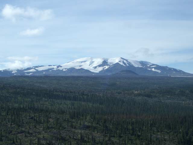
Fort Selkirk is a volcanic field near the junction of the Yukon and Pelly rivers in central Yukon. It is the northernmost young volcanic field in Canada.
The volcano consists of large valley-filling lava flows and 3 cinder cones.
The volcanic field developed at the in... [
plus d'info]
(stratovolcano 2678 m / 8,786 ft)
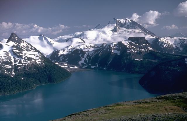
Mount Garibaldi, rising above scenic Garibaldi Lake to the north, is a largely Pleistocene stratovolcano capped by a lava dome complex. The volcano was partially constructed over the Cordilleran ice sheet and displays many ice-contact features. Its final eruptions during the early Holocene included the emission of lava flows that mantled the west-side landside headwall and a massive lava flow from Opal Cone, a SE flank vent, that traveled 20 km to the south and west. Photo by Lee Siebert, 1983 (Smithsonian Institution)
Mt Garibaldi volcano at the head of Howe Sound, 66 km north of Vancouver in SW British Columbia is probably Canada's best-known volcano and part of the active Cascades Range. It is a young stratovolcano capped by a complex of lava domes. Its most recent eruptions occurred at the ... [
plus d'info]
(volcanic field 2316 m / 7,598 ft)
Garibaldi Lake is a group of 9 small small andesitic stratovolcanoes and basaltic-andesite cones located 70 km north of Vancouverin SW British Columbia, Canada. The most recent eruptions occurred from Clinker Peak probably around 10,000 years ago. [
plus d'info]
(shield volcano 2012 m / 6,601 ft)
Heart Peaks shield volcano is located NW of Level Mountain in NW British Columbia, Canada. It is the third largest center in the northern Cordilleran volcanic province. The volcano, covering an area of 275 sq km, last erupted during the last ice ages, and it is uncertain whether ... [
plus d'info]
(subglacial volcano 1850 m / 6,070 ft)
Hoodoo Mountain is located north of the Iskut River in the Coast Mountains of northwestern British Columbia, Canada. The volcano formed under glacial ice, and a 3-4 km wide ice cap still covers the upper part above 1750 m elevation, forming 2 glaciers, the Hoodoo glacier on the n... [
plus d'info]
(cinder cones 1880 m / 6,168 ft)
A field of 8 cinder cones near the Iskut-Unuk River in NW British Columbia, Canada, is located at the southern end of the Stikine volcanic belt. [
plus d'info]
(shield volcano 2190 m / 7,185 ft)
Level Mountain in NW British Columbia, Canada, SW of Dease Lake and north of Telegraph Creek is the most voluminous and most active volcano of the Stikine volcanic belt. [
plus d'info]
(complex volcano 2680 m / 8,793 ft)
Meager volcano is a young andesitic-to-rhyodacitic stratovolcano located 150 km north of Vancouver in SW British Columbia, Canada. It is the northernmost member of the Cascade Range volcano which extend into northern California, USA. [
plus d'info]
(cinder cones 335 m / 1,099 ft)
Milbanke Sound volcanic field in NW British Columbia, Canada is a group of cinder cones and lava flows on Swindle, Lake, Price, and Lady Douglas Islands in Milbanke Sound. The best preserved and probably youngest cone is Kitasu hill rising from the southern coast of Swindle Islan... [
plus d'info]
(cinder cones 1230 m / 4,035 ft)
Nazko is a small, tree-covered cinder cone in central British Columbia, Canada, located approximately 75 km west of Quesnel. It last erupted about 5220 years ago (radiocarbon dated). [
plus d'info]
(volcanic field 1921 m / 6,302 ft)
The Satah Mountain volcanic field in the Central Interior of British Columbia, Canada, is an extensive N-S trending volcanic chain that stretches south of the Itcha Range shield volcano to northeast of Nimpo Lake. The last eruptions took place around 7,200 years ago. [
plus d'info]
(caldera 3160 m / 10,367 ft)
Silverthrone is a large volcanic complex with a 20 km wide dissected caldera located in SW British Columbia NW of the head of Knight Inlet, Canada. [
plus d'info]
(stratovolcano 2430 m / 7,972 ft)

Strange flows near the Raspberry Pass area of the Spectrum Range. (photo: Wikimedia Commons)
Spectrum Range, south of Mount Edziza, in NW British Columbia, is one of four large composite volcanoes that make up the
Mount Edziza-Spectrum Range volcanic complex.
Similar to the other 3 central volcanoes, Spectrum Range stratovolcano is formed... [
plus d'info]
(cinder cone 600 m / 1,969 ft)
Tseax Cone (also called Tseax River Cone or the Aiyansh volcano) is a young cinder cone in the Northern Cordilleran Volcanic Province in British Columbia, Canada. It is the site of one of Canda's most recent eruptions, which was a major lava flow around the years 1750 or 1775. Ts... [
plus d'info]
(volcanic field 2123 m / 6,965 ft)
The Tuya volcanic field is a broad volcanic region near Lake Tuya in the Cassiar Mountains and Tanzilla Plateau area of northern British Columbia, Canada. It contains small shield volcanoes and cinder cones which were formed under glacial ice. They are the type locality of so-cal... [
plus d'info]
(cinder cones 2015 m / 6,611 ft)
The Wells Gray-Clearwater volcanic field is located in the Quesnel Highland of east-central British Columbia, Canada. The volcanoes are basaltic cinder cones and their lava flows. The latest eruption took place from Kostal cone about 400 years ago, thus being one of the most rece... [
plus d'info]


