Contact | RSS | EN | DE | EL | ES | FR | IT | RU

Volcanoes of Iceland

Askja | Bardarbunga | Blafell | Blafjall | Brennisteinsfjöll | Burfell | Eldey | Eríksjokull | Esjufjöll | Eyafjallajökull | Fjallgardar Ridge | Fremrinámar | Gaesafjoll | Geysir | Grensdalur | Grímsnes | Grímsvötn | Heiðarsporðar | Hekla | Helgrindur | Hengill | Herdubreid | Hlodufell | Hofsjökull | Hreppar | Hrómundartindur | Hrutfell | Hveravellir | Katla | Kerlingarfjöll | Kistufell | Kolbeinsey Ridge | Krafla | Krísuvík | Kverkfjöll | Lambafjoll | Langjökull | Ljósufjöll | Loki-Fögrufjöll volcano | Lyngdalsheidi | Lysuhóll | Ok | Öraefajökull | Prestahnukur | Reykjanes | Sellandafjall | Snaefellsjökull | Strutur | Theistareykjarbunga | Thordarhyrna | Thorisjokull | Tindfjallajökull | Tjörnes Fracture Zone | Torfajökull | Tungnaarfjoll | Tungnafellsjökull | Valdalda | Vatnafjöll | Vestmannaeyjar

Péninsule de Reykjanes, Islande (4 volcans)

Brennisteinsfjöll | Fagradalsfjall | Krísuvík | Reykjanes
[plus petit] [plus gros]

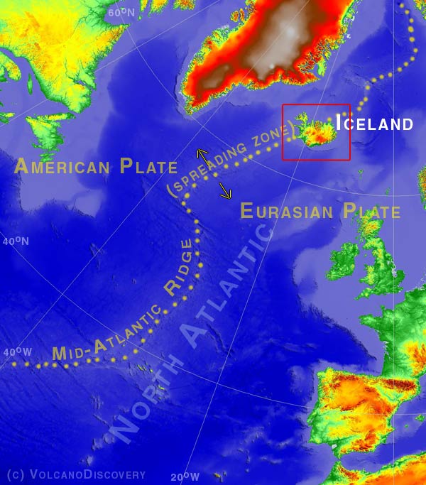
Localisation de l'Islande et de la ride médio-océanique Atlantique Nord où les plaques Américaine et Eurasienne se séparent
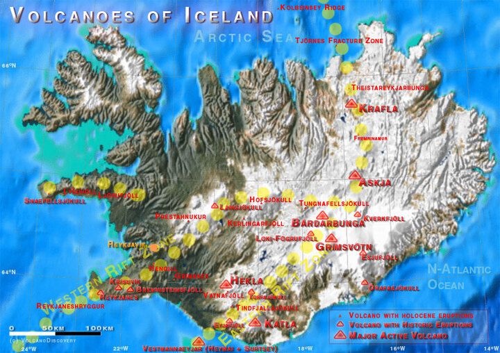
Carte simplifiée de l'Islande montrant les volcans actifs

L'Islande et ses volcans:


L'Islande a la superficie de la Virginie et possède une population comparable à celle de Virginia Beach (près de 260.000 personnes). Le pays a le taux d'alphabétisation le plus élevé (100 %) de toutes les nations dans le monde. Son histoire a toujours été étroitement liée aux volcans et aux connaissances d'un grand nombre d'éruptions volcaniques qui depuis le Moyen-âge ont été conservées dans des écrits.

Tout d'abord instauré par les Vikings dans le 9e siècle AD, l'Islande établi son propre Parlement en 930 et a enregistré sa première éruption volcanique historique  seulement quelques années plus tard. Après un âge d'or de la littérature au cours des 12e et 13e siècles (lorsque les sagas ont été écrites), les rapports d'histoire naturelle ont atteint un faible taux autour du 15ème siècle . Dans les années 1707-09 un tiers de la population meurent de la variole, et l'éruption du Laki durant 1783-84 tua un cinquième de la population restante par la famine. L'Islande acquis la souveraineté du Danemark en 1918 et pris son indépendance totale en 1944.
L'Islande est notée pour ses éruptions fissurales sous-glaciaires et régionales rattachées au processus de rifting entre les plaques tectoniques qui se séparent.
---
(adapté à partir des infos du GVP/Smithsonian Institution)
Actualitées
mer., 24 avril 2024, 14:00

Reykjanes volcano (Reykjanes Peninsula) - Smithsonian / USGS Weekly Volcanic Activity Report for 17 April-23 April 2024 (Continuing Activity)

IMO reported that the cone just E of Sundhnúk and along the fissure within the Reykanes volcanic system continued to erupt lava during 15-23 April. Gas emissions continued to drift downwind and residents were advised to monitor air quality. Lava flowed a short distance from the crater mostly S and the flows thickened near the crater. ... Read all
mer., 24 avril 2024, 03:00

Reykjanes volcano update: lava has thickened along protective barriers

The thermal anomaly in the vicinity of the spatter cone and in the southern part of the lava flow field as seen from space on 22 April (image: Landsat 8-9)
The eruption continues without any significant change in the activity since the last update. ... Read all
Découvrez notre app gratuite !
Volcanoes & Earthquakes - new app for Android
Android | Version iOS

Plus sur VolcanoDiscovery

Why is there advertising on this site?

Support us - Help us upgrade our services!

We truly love working to bring you the latest volcano and earthquake data from around the world. Maintaining our website and our free apps does require, however, considerable time and resources.
We need financing to increase hard- and software capacity as well as support our editor team. We're aiming to achieve uninterrupted service wherever an earthquake or volcano eruption unfolds, and your donations can make it happen! Every donation will be highly appreciated. If you find the information useful and would like to support our team in integrating further features, write great content, and in upgrading our soft- and hardware, please make a donation (PayPal or Online credit card payment).

Planned features:Thanks to your past donations, these features have been added recently:
Download and Upgrade the Volcanoes & Earthquakes app to get one of the fastest seismic and volcano alerts online:
Android | IOS
Thank you!
Copyright: VolcanoDiscovery ou autres sources indiquées.
Utilisation des documents: Les textes, les images et les vidéos de ce site internet sont protégées par copyright. Toute reproduction et tout usage sans accord préalable ne sont pas autorisés. Si vous désirez acquérir pour certains documents (photos, vidéos, textes ou autres) le droit de reproduction, d'édition et, plus généralement, de toute utilisation destinée à un usage public, qu'elle soit commerciale ou pas, vous êtes priés de nous contacter.
Volcanoes & Earthquakes
VolcanoDiscovery Home
Volcans | Séismes | Photos | Actualités | App
Adventure & Study Travel
Tours to Volcanoes and Volcanic Areas: walking tours, photo tours, study tours
Voyages |
Get our newsletter!
Company info
Contact | Mentions légales | Terms & conditions
Follow us
Follow us on facebook Follow us on Instagram Follow us on Twitter Visit our Youtube channel
EN | DE | EL | ES | FR | IT | RU
VolcanoDiscovery GmbH, Germany, Reg. nr.: HRB 103744, EU Tax Id: DE 297 465 123 owned and created by
Dr. Tom Pfeiffer, volcanologist, volcano photographer, tour organizer member of
IAVCEI
IAVCEI
Vulkanologische Gesellschaft
Volcanological Society
Ecotourism Greece
Ecotourism Greece
RUV insurance
Insured by R+V
VolcanoDiscovery © 2004- All Rights Reserved | Privacy - Changer Préférences