Contact | RSS | EN | DE | EL | ES | FR | IT | RU

Michinmahuida Volcano

Updated: Apr 25, 2024 13:38 GMT -
stratovolcano 2404 m / 7,887 ft
southern Chile, -42.79°S / -72.44°W
Current status: normal or dormant (1 out of 5)
Glacier-covered Volcán Minchinmávida is elongated along a NE-SW direction. The volcano has a mostly obscured 3-km-wide caldera, and a youthful eruptive center is located on the ENE side of the complex. An eruption from Minchinmávida was reported in 1742. Darwin observed the volcano in activity in 1834 on his renowned voyage that took him to the Galápagos Islands. (NASA International Space Station image ISS006-E-42260, 2003, http://eol.jsc.nasa.gov/)

Volcán Michinmahuida (also written Minchinmávida) volcano is an active basaltic-to-andesitic stratovolcano in southern Chile, west of Lago Reñihue. It was observed and in activity by C. Darwin in 1834 during his historic journey to the Galapagos Islands.
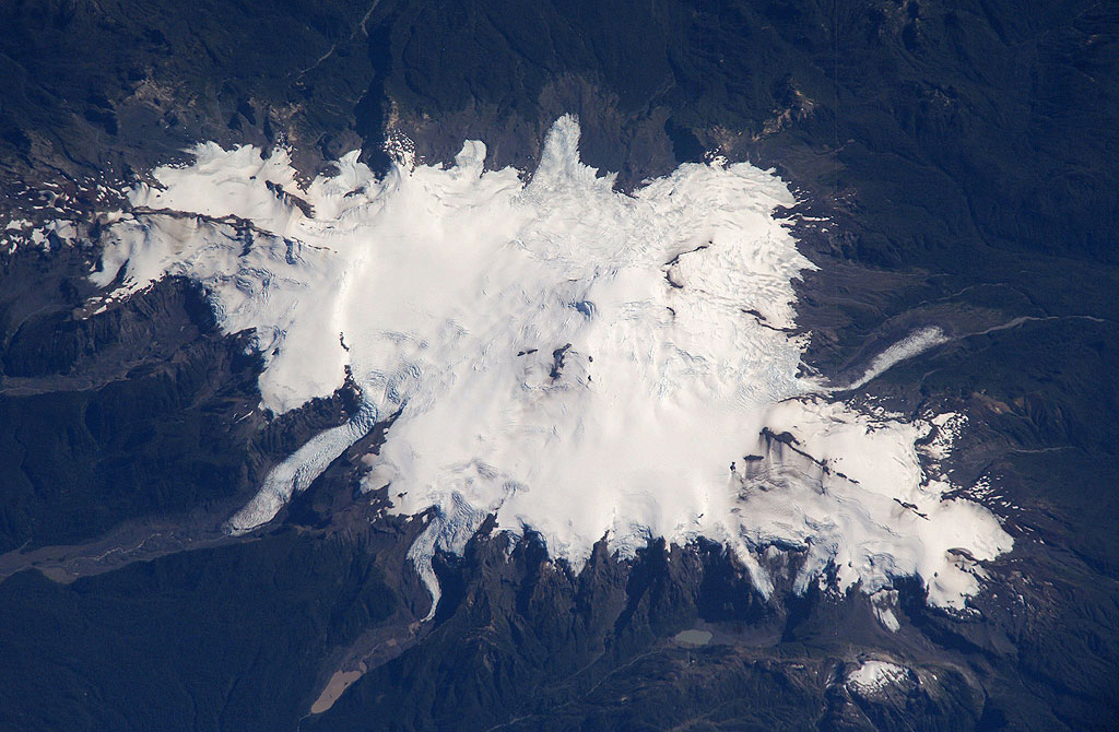
The massive glacier-coverd volcano is elongated in a NE-SW direction and and has a saddle-shaped summit with an elongated 3-km-wide caldera. A young crater is located on the ENE side of the complex.
2 major explosive eruptions had occurred about 3000 and 6000 years ago and produced significant tephra deposits extending to the east. Activity in historic times consisted of small explosive eruptions. The last eruption was from February to March 1835, produced a lava flow from a flank crater as well as lahars that reached the coast at Punta Chana.

When neighboring Chaitén erupted after a century-long repose interval in 2008, it was first believed that Michinmahuida was having a new eruption, since Chaitén was poorly known at that time.

[smaller] [larger]
Typical eruption style: explosive
Michinmahuida volcano eruptions: 1835, 1834, 1742, 1650 ± 50 years (?), 880 BC ± 1000 years, 3790 BC ± 500 years

Latest nearby earthquakes

No recent earthquakes
TimeMag. / DepthDistance / Location

Eruptions of Michinmahuida volcano


1835 eruption
Minchinmavida, along with Cerro Yanteles volcano further south, erupted in 1835 within a day of a magnitude 8.1 earthquake between 600 and 800 km away (Darwin, 1840).

Sources:
- Michael Manga and Emily Brodsky (2006) "Seismic Triggering of Eruptions in the Far Field: Volcanoes and Geysers", Annu. Rev. Earth Planet. Sci 34: pp 263–91
- Darwin C. (1840) "On the connexion of certain volcanic phenomena in South America; and on the formation of mountain chains and volcanoes, as the effect of the same power by which continents are elevated." Trans. Geol. Soc. Lond. 5: pp 601–31

Latest satellite images

Michinmahuida satellite image sat1Michinmahuida satellite image sat2

No news in this list.

On this page:

Try our free app!
Volcanoes & Earthquakes - new app for Android
Android | iOS version

More on VolcanoDiscovery

Why is there advertising on this site?

Support us - Help us upgrade our services!

We truly love working to bring you the latest volcano and earthquake data from around the world. Maintaining our website and our free apps does require, however, considerable time and resources.
We need financing to increase hard- and software capacity as well as support our editor team. We're aiming to achieve uninterrupted service wherever an earthquake or volcano eruption unfolds, and your donations can make it happen! Every donation will be highly appreciated. If you find the information useful and would like to support our team in integrating further features, write great content, and in upgrading our soft- and hardware, please make a donation (PayPal or Online credit card payment).

Planned features:Thanks to your past donations, these features have been added recently:
Download and Upgrade the Volcanoes & Earthquakes app to get one of the fastest seismic and volcano alerts online:
Android | IOS
Thank you!
Sources: VolcanoDiscovery / VolcanoAdventures and other sources as noted.
Use of material: Most text and images on our websites are owned by us. Re-use is generally not permitted without authorization. Contact us for licensing rights.
Volcanoes & Earthquakes
VolcanoDiscovery Home
Volcanoes | Earthquakes | Photos | Volcano News | App
Adventure & Study Travel
Tours to Volcanoes and Volcanic Areas: walking tours, photo tours, study tours
Tours & Dates | FAQ | About us
Get our newsletter!
Company info
Contact | Legal info | Terms & conditions
Follow us
Follow us on facebook Follow us on Instagram Follow us on Twitter Visit our Youtube channel
EN | DE | EL | ES | FR | IT | RU
VolcanoDiscovery GmbH, Germany, Reg. nr.: HRB 103744, EU Tax Id: DE 297 465 123 owned and created by
Dr. Tom Pfeiffer, volcanologist, volcano photographer, tour organizer member of
IAVCEI
IAVCEI
Vulkanologische Gesellschaft
Volcanological Society
Ecotourism Greece
Ecotourism Greece
RUV insurance
Insured by R+V
VolcanoDiscovery © 2004- All Rights Reserved | Privacy - Cookie Settings