A new weak thermal anomaly located inside Nabro's summit caldera was detected on 29 Jan on satellite infrared images by MODVOLC. It suggests that some sort of activity still goes on there.
According to NASA's Earth Observatory, satellite images of Nabro acquired on 28 September showed heat from the vent in the central crater, and from an area 1.3 km S of the vent that indicated an active lava flow. A small and diffuse plume rose from the vent. A region of seemingly thicker black ash (that completely covered the sparse vegetation) was noted S of the crater and thinner layers of ash (with some areas of visible vegetation) flanked either side of the region.
Wed, 13 Jul 2011, 06:00
Based on analyses of satellite imagery, the Toulouse VAAC reported that on 16 July an ash plume from Nabro rose to altitudes below 5.5 km (18,000 ft) a.s.l. A weak eruption detected on 17 July decreased through the day then appeared to have stopped.
Read allWed, 29 Jun 2011, 06:00
A satellite image of Nabro acquired on 29 June showed a clear view of the caldera and the vent within the active crater near the middle of the caldera. Lava flows to the W, and within the crater (E and S of the vent), continued to be hot. A brown ash plume rose from the vent and drifted S.
Read allWed, 22 Jun 2011, 09:53
The eruption at Nabro volcano is continuing. The explosive phase seems to have ended, but there is still a large white steam and gas plume coming from the volcano and a large hot spot is visibe on the MODIS/Terra satellite images. Most likely, large lava flows are still being erupted.
Read allWed, 22 Jun 2011, 06:00
A satellite image of Nabro acquired on 22 June showed a gas-and-ash plume rising from the caldera and drifting W. According to a news article, the eruption resulted in at least seven deaths, injured many, and displaced thousands in Eritrea, and affected about 5,000 Ethiopians living near the border. Two satellite images acquired on 24 June show the erupting vent, plumes and emissions, and lava flows in detail.
Read allFri, 17 Jun 2011, 15:13
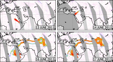
Nabro SO2 plume 14-17 June (OMI data, KNMI.FMI/NASA). Original images from ESA SACS, composite from The Volcanism Blog (volcanism.wordpress.com)
The eruption at Nabro volcano in Eritrea that started 5 days ago seems to have decreased a lot in intensity, or even have stopped.
Read allWed, 15 Jun 2011, 06:00
An eruption from Nabro that started on 12 June continued to produce a plume. Based on analyses of satellite imagery, the Toulouse VAAC reported that during 15-20 June plumes comprised mostly of water and sulfur dioxide rose to altitudes of 6.1-7.9 km (20,000-26,000 ft) a.s.l. Ash was occasionally detected near the volcano.
Read allMon, 13 Jun 2011, 15:57
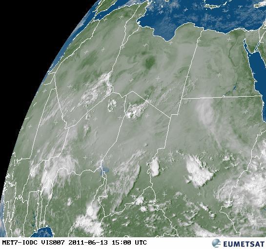
![Meteosat satellite image from 13 June, 15h00 UTC showing the volcanic ash plume over Sudan and into Egypt. (source: http://oiswww.eumetsat.org/)]()
Meteosat satellite image from 13 June, 15h00 UTC showing the volcanic ash plume over Sudan and into Egypt. (source: http://oiswww.eumetsat.org/)
The eruption plume from the ongoing eruption at Nabro volcano is driffting at an altitude of ca. 7km (20,000 ft, flight level 200) and has reached southern Egypt. It is well visible on satellite images.
Mon, 13 Jun 2011, 08:35
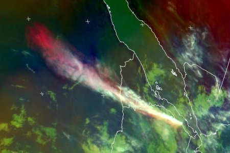
![Eumetsat image, 08:00UTC. Thanks to <link http://volcanism.wordpress.com/2011/06/13/eruption-in-eritrea-1000-km-plume/>this post on The Volcanism Blog</link>: http://volcanism.word ...]()
Eumetsat image, 08:00UTC. Thanks to <link http://volcanism.wordpress.com/2011/06/13/eruption-in-eritrea-1000-km-plume/>this post on The Volcanism Blog</link>: http://volcanism.wordpress.com/2011/06/13/eruption-in-eritrea-1000-km-plume/
Following a swarm of intense earthquakes, a new and apparently large explosive eruption started last night in Eritrea near the Ethiopian border, in an area which is the continuation of the spreading rift axis of the Red Sea.
Read allWed, 8 Jun 2011, 06:00
According to the USGS Earthquake Hazards Program, an earthquake swarm was detected during the evening of 12 June on the border of Ethiopia and Eritrea, in the vicinity of Nabro, the most prominent of three volcanoes with large summit calderas aligned in a NE-SW direction SW of Dubbi volcano. The swarm began at 1837 with an M 5.1 earthquake. Several more were detected between M 4.3 and 5.1 over the next few hours.
Read all