Telica Volcano
Updated: 25 апр 2024 20:05 GMT -
Stratovolcano(es) 1061 m / 3,481 ft
Nicaragua, 12.6°N / -86.85°W
Current status: normal or dormant (1 out of 5)
Nicaragua, 12.6°N / -86.85°W
Current status: normal or dormant (1 out of 5)
Last update: 14 окт 2023 (Smithsonian / USGS Weekly Volcanic Activity Report)
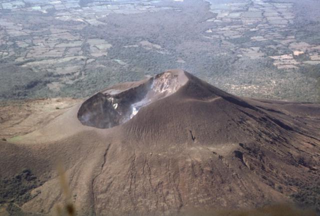
Telica volcano (image: GVP)
Telica, one of the most active volcanoes in Nicaragua, is a group of overlapping cones and craters on a broad NW line. The most prominent vent is a 700 m wide and 120 m deep double crater at the summit. Its southern summit crater has been the source of Telica's recent eruptions.
The older Santa Clara vent at the SW end of the edifice erupted in 16th century and is now covered with vegetation. Another vent El Liston, immediately SE of Telica, is another volcanic edifice with several nested craters.
Fumaroles and boiling mudpots are found at Hervideros de San Jacinto, SE of Telica. This prominent geothermal area is popular among tourists and the site of nearby geothermal exploration.
[smaller] [larger]
Telica volcano eruptions: 2016, 2015, 2013, 2011, 2007, 2006, 2004, 1999-2000, 1994, 1987, 1981-82, 1981, 1976-78, 1975-76, 1969-71, 1966, 1965, 1962, 1951, 1948-49, 1946, 1943-44, 1941(?), 1940, 1939, 1939, 1937-38, 1934, 1929, 1928, 1927, 1918(?), 1907, 1791, 1765, 1743(?), 1685, 1613, 1529, 1527(?)
Latest nearby earthquakes
| Время | Магнитуда / Глубина | Расстояние / Местоположение | |||
| 25 апр 12:42 (Managua) | 1.6 12 km | Более | |||
| 24 апр 18:41 (Managua) | 1.9 5 km | 7.9 km к востоку | Более | ||
| Вторник, 23 апреля 2024 GMT (1 земл.) | |||||
| 23 апр 13:40 (Managua) | 2.2 6 km | 20 km к юго-востоку | Более | ||
| Четверг, 18 апреля 2024 GMT (2 земл.) | |||||
| 18 апр 14:43 (Managua) | 1.6 26 km | Более | |||
| 18 апр 09:14 (Managua) | 1.5 43 km | Более | |||
| Вторник, 16 апреля 2024 GMT (1 земл.) | |||||
| 16 апр 04:27 (Managua) | 1.1 2 km | Более | |||
Извержения вулкана Telica
2007 eruptions: ash emissions
In January and February 2007, there were small ash eruptions producing ash clouds reaching altitudes of 5000 ft (1,8 km).
In January and February 2007, there were small ash eruptions producing ash clouds reaching altitudes of 5000 ft (1,8 km).
1999-2000 eruptions
Telica volcano became active in August 1999. On 10 August 1999, an eruption produced ash fall 20 km WSW of Telica in the city of Chichigalpa.
A lava lake in the summit crater was observed on 18 August. The ash eruptions continued until February 2000 and declined afterwards.
Telica volcano became active in August 1999. On 10 August 1999, an eruption produced ash fall 20 km WSW of Telica in the city of Chichigalpa.
A lava lake in the summit crater was observed on 18 August. The ash eruptions continued until February 2000 and declined afterwards.
Latest satellite images