Dieng Volcano
Updated: Apr 19, 2024 04:30 GMT -
Complex volcano 2565 m (8415 ft)
Central Java (Indonesia), -7.22°S / 109.9°E
Current status: normal or dormant (1 out of 5)
Central Java (Indonesia), -7.22°S / 109.9°E
Current status: normal or dormant (1 out of 5)
Last update: 9 Mar 2023 (Smithsonian / USGS Weekly Volcanic Activity Report)
The Dieng volcanic complex forms a 6x14 km large highland plateau in Central Java west of Yogyakarta. It consists of overlapping volcanoes and a large caldera, lava domes, cones, and explosion craters many of which are filled by lakes.
It is known for its varied colorful volcanic scenery and hydrothermal activity, and a sacred area to the Javanese people; some of the oldest Hindu temples of Java are found here, dating back to the 8th century AD.
[smaller] [larger]
Dieng volcano eruptions: 2017, 2011, 2009, 2005, 1993, 1986, 1981, 1979, 1964, 1956, 1954, 1953, 1952 (?), 1944, 1943, 1939, 1928, 1883-84, 1847, 1826, 1825, 1786, 1776 (?), 1375
Latest nearby earthquakes
| Time | Mag. / Depth | Distance / Location | |||
Background
The Dieng volcanic complex was formed by at least two overlapping stratovolcanoes, Butak Petarangan and Prahu. The latter was destroyed and truncated by a caldera formation less than 10,000 years ago. About 20 small geologically younger craters, lava domes, cinder cones and explosion craters dot the area. Some of the craters are filled by warm acidic lakes, including: the craters of Bismo, Srojo, Binem, Pangonan, Merdodo, Pagerkandang, Nogosari, Petarangan, Telogo Dringo, Pakuwaja,Kendil, Kunir and Prambanan.Lava flows cover much of the plateau, but none of them have erupted in historic time. Historic activity at Dieng consited in small phreatic eruptions. Emissiong of toxic volcanic gas has caused fatalities and remains a hazard at several craters. There have been at least 18 historic eruptions and 8, which caused fatalities.
The strong heat flow on the plateau of Dieng creates numerous hydrothermally active areas with boiling mud ponds, fumaroles, warm springs etc. The most interesting hydrothermal areas include Kawah Sikidang, Kawah Sigajah, Kawah Kumbang, Kawah Sibanteng, Kawah Upas,Telogo Terus, Kawah Pagerkandang, Kawah Sipandu, Kawah Siglagah, Kawah Sileri, Telogo Dringo and Condrodimuko.
The intense heat flow of the area makes it a prime target for geothermal prospect.
Eruptions of Dieng volcano
September 2009 eruption
One or two phreatic eruptions occured at Sileri crater on 26-27 September. ...more info
One or two phreatic eruptions occured at Sileri crater on 26-27 September. ...more info
January 2009 eruption - landslide and phreatic explosion
A small phreatic eruption occured on 16 Jan 2009 at Sibateng crater. ...more info
A small phreatic eruption occured on 16 Jan 2009 at Sibateng crater. ...more info
1992 gas eruption
A sudden gas emissions ocurred at 16h00 on 18 March 1992. One person was killed by CO2 in a river valles 200 m W of Sikidang Crater, and two people trying to rescue him had to be hospitalized.
A sudden gas emissions ocurred at 16h00 on 18 March 1992. One person was killed by CO2 in a river valles 200 m W of Sikidang Crater, and two people trying to rescue him had to be hospitalized.
1979 eruption - deadly gas emissions
The last eruption at Dieng causing a large number of fatalities happened on 20 February 1979. Large gas emissions (CO2, most likely, or H2S) occured along with at least two phreatic eruptions from Sinila and Sigludung craters. At least 149 people were killed, when they fled the explosions and were cought in the deadly gas cloud. Many hundreds were severely injured.
Around 15,000 people were evacuated from six villages near Sinila. Fish and livestock were killed by the eruption. The eruption had been preceded by at least 3 felt earthquakes.
1964 eruption
An eruption in 1964 caused 114 deaths.
An eruption in 1964 caused 114 deaths.
1944 eruption
An explosion occurred from Kawah Sileri crater during the night of 4 Dec 1944. The powerful explosion occured in darkness and showered rocks and boiling mud over parts of the villages Kepakisan, Sekalem, Sidolok, Pagerkandang, Djawera and Kepakisanlor. in complete darkness. Some blocks were thrown up to 1 km distance from the vent. An estimated 117 people people were killed, and more than 200 severely injured by ballistic impact and burns from boiling mud.
An explosion occurred from Kawah Sileri crater during the night of 4 Dec 1944. The powerful explosion occured in darkness and showered rocks and boiling mud over parts of the villages Kepakisan, Sekalem, Sidolok, Pagerkandang, Djawera and Kepakisanlor. in complete darkness. Some blocks were thrown up to 1 km distance from the vent. An estimated 117 people people were killed, and more than 200 severely injured by ballistic impact and burns from boiling mud.
1939 eruption
A violent phreatic eruption happened at Dieng volcano on 13th October 1939 near the northern side of the Chinese cementary. Hot mud erupted from a new fissure. Activity ended on 3 November 1939.
A violent phreatic eruption happened at Dieng volcano on 13th October 1939 near the northern side of the Chinese cementary. Hot mud erupted from a new fissure. Activity ended on 3 November 1939.
1928 eruption
A phreatic explosion in 1928 near Timpang killed about 40 people, one by a falling block.
A phreatic explosion in 1928 near Timpang killed about 40 people, one by a falling block.
Eruptions in 1826 and 1827
The eruptions in 1826 and 1827 caused several fatalities.
The eruptions in 1826 and 1827 caused several fatalities.
1786 eruption
Fissures opened in the ground and destroyed the village of Jamping killing 38 people.
Fissures opened in the ground and destroyed the village of Jamping killing 38 people.
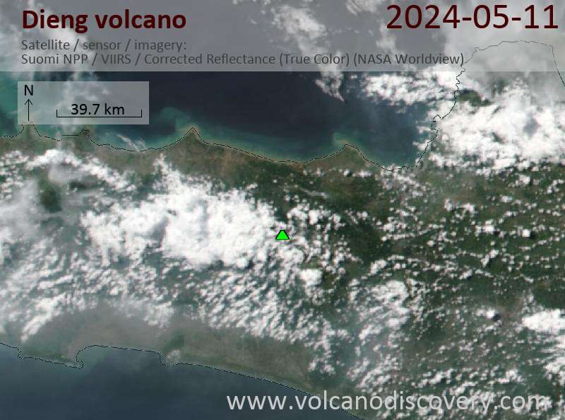
Latest satellite images