(pyroclastic shield 518 m / 1,699 ft)
Apoyeque volcano forms the broad Chiltepe Peninsula in western Nicaragua and extends into south central Lake Managua
The Apoyeque volcano is part of a larger volcanic complex and consists of a low 500 m high shield cut by a 2.8 km wide and 400 deep lake-filled caldera and a... [
more info]
(stratovolcano 603 m / 1,978 ft)
Cerro el Ciguatepe volcano is located in the Nicaraguan interior highlands, east of the Nicaraguan depression and one of several Quarternary volcanoes in this area.
It contains a well-reserved 1.5 km wide summit crater, which contains a blocky lava dome and a young lava fl... [
more info]
(cinder cones 728 m / 2,388 ft)
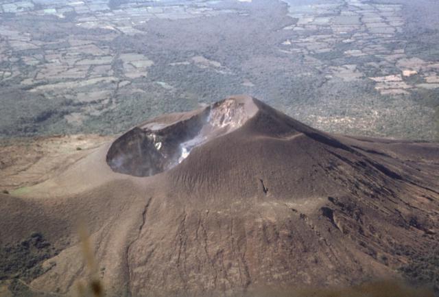
Cerro Negro, Central America's youngest volcano was born in April 1850 and is one of the region's most active volcanoes. It has been producing frequent strombolian eruptions, occasional lava fountains and lava flows, and powerful explosive eruptions every few decades.
Cerro... [
more info]
(stratovolcano 1700 m / 5,577 ft)

The steep stratovolcano Conception in January 2012 (photo: Antony / www.facebook.com/antony.van)
Concepción volcano is a steep symmetrical stratovolcano with a perfect shape and one of the most active volcanoes of Nicaragua. During the past 100 years, it has been in a near-constant state of small to medium ash explosions at irregular intervals.
Together with its neighb... [
more info]
(stratovolcano 872 m / 2,861 ft)
Cosigüina (or Cosegüina) volcano in western Nicaragua forms a large peninsula into the Gulf of Fonseca. The last eruption of the volcano was in 1959, but periods of unrest have occurred in recent years and in 1835, it produced the largest known historic eruption in Nicaragua.
more info]
(volcanic field 899 m / 2,949 ft)
Esteli volcano is a group of young fissure vents, cones and lava flows located 36 km south of Honduras in the northern interior highlands between the town of Estelí and the border. The volcanic center is not on the main volcanic front of Nicaragua, but 70 km NE of the main volcan... [
more info]
(fissure vents 300+ m / 984 ft)
Granada volcano is a system of N-S trending fissure vents, cinder cones and craters located in western Nicaragua between the city of Granada (the oldest city founded by Europeans on the American continent) on the northwestern shore of Lake Nicaragua and the northern flanks of Mom... [
more info]
(shield volcano 926 m / 3,038 ft)
Las Lajas is a basaltic shield volcano 20 km north of Lake Nicaragua. La Lajas is the youngest of a group of volcanoes east of the Nicaraguan graben. Based on its fresh morphology, it could be still active.
Las Lajas volcano has a 7 km wide and 650 m deep caldera, which co... [
more info]
(volcanic field 1088 m / 3,570 ft)
Las Pilas volcano is a volcanic complex near Cerro Negro volcano 75 km NW of the capital Managua.
The volcano consists of several cones around the central vent, Las Pilas, which contains a 700 m wide and 120 m deep crater and is the site of the recent activity.
El Ho... [
more info]
(stratovolcano 1394 m / 4,573 ft)
Maderas volcano is a basaltic to dacitic stratovolcano on the SE end of Ometepe island in Lake Nicaragua. It has a a 800 m wide summit crater which contains the small lake Laguna de Maderas at the bottom.
Maderas is still active, but the latest activity dates back more than... [
more info]
(Pyroclastic shield 181 m / 594 ft)
[
more info]
(caldera 635 m / 2,083 ft)
Masaya volcano 25 km SE from Managua is one of Nicaragua's most active and usual volcanoes.
In contrast to most other volcanoes in subduction zones, it has been erupting mainly fluid basaltic lava. At the time of the Spanish Conquistadors, it contained an active lava lake ... [
more info]
(stratovolcano 1344 m / 4,409 ft)
Mombacho volcano is an active andesitic and basaltic stratovolcano located about 10 km south of the city of Granada, west of Lake Nicaragua and a few kilometers SE of Laguna Apoyo.
A possible historic eruption occurred in 1570, when a debris avalanche destroyed a village on... [
more info]
(stratovolcano 1297 m / 4,255 ft)
Momotombo volcano is a symmetrical stratovolcano rising as a peninsula above the NW part of Lake Managua, Nicaragua. It is one of the most known volcanoes of the country.
Momotombo is located at the SE end of the Marrabios Range. It consists of the remnant of an older volca... [
more info]
(fissure vents 360 m / 1,181 ft)
Nejapa-Miraflores volcano is an alignment of fissure vents, maars and cinder cones extending from Lake Managua until the western part of Managua city.
About 40 eruptions have occurred from this system during the past 30,000 years, and the most recent one produced Asososca ... [
more info]
(stratovolcano 832 m / 2,730 ft)
Rota (also known as Orota) volcano in Nicaragua is located between the more active Cerro Negro and Telica volcanoes in the central Marrabios Range. It is a symmetrical stratovolcano truncated by a 1 km wide circular crater.
There are no recent eruptions from Rota, and the c... [
more info]
(stratovolcano 1745 m / 5,725 ft)
San Cristobal volcano, also known as El Viejo, is the highest and one of the most active volcanoes in Nicaragua. It is located near the northwest corner of the country near the city of Chinandega, 110 km WSW of the capital Managua.
San Cristobal has had frequent small to m... [
more info]
(Stratovolcano(es) 1061 m / 3,481 ft)
Telica volcano (image: GVP)
Telica, one of the most active volcanoes in Nicaragua, is a group of overlapping cones and craters on a broad NW line. The most prominent vent is a 700 m wide and 120 m deep double crater at the summit. Its southern summit crater has been the source of Telica's recent eruptions. ... [
more info]
(cinder cones 201 m / 659 ft)
Volcán Azul (also known as Volcán Blue) a group of 3 cinder cones located on the Atlantic coastal plain of Nicaragua. The volcanic cones are in an area covered by dense rainforest and were discovered during an aerial survey in the 1960s.
Note: There is another
more info]
(shield volcano 629 m / 2,064 ft)
Zapatera volcano is a low shield volcano forming a 7 x 10 km wide densely forested island on the western part of Lake Nicaragua. The island is located opposite
Mombacho volcano and separated by a narrow strait from the mainland.
Zapatera volcano... [
more info]