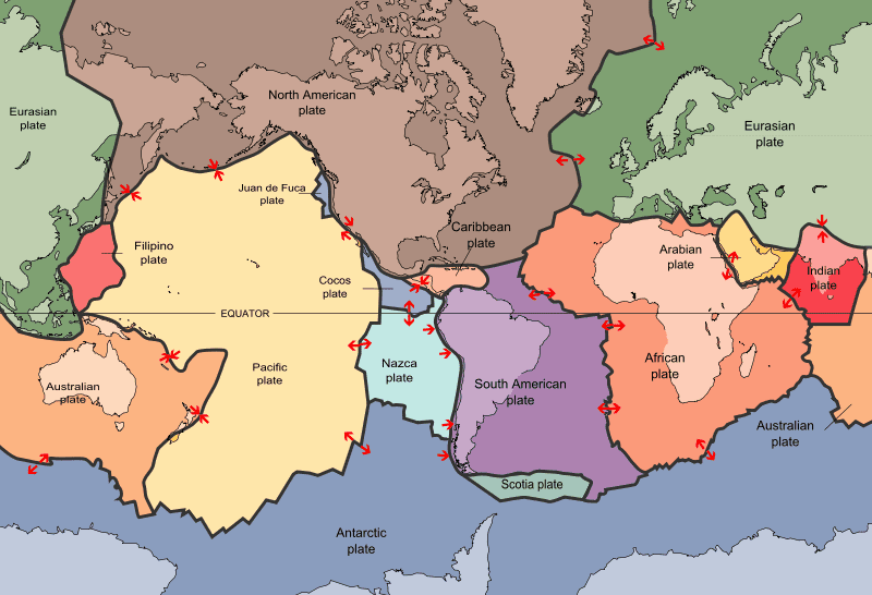
Plates, plate motion and mantle convection
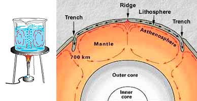
Schematic cross-section of the earth illustrating mantle convection (USGS)
Tectonic plates are composed of the rigid outer portion of the earth, called lithosphere (from the Greek word "lithos"="rock"). With a thickness of about 100 km, the lithosphere is composed of an upper layer of crust (~7 km thick under the oceans, and ~50 km thick under the continents) and a lower, denser layer of the earth's upper mantle. The rest of the mantle underlying the plates is sufficiently hot to be mobile, although by far the largest part of it is solid. Despite the high temperature, the effect of pressure inside the mantle usually prevents melting.
The rigid lithosphere plates are driven by convection within the mobile asthenosphere. Hot mantle rises beneath mid-oceanic ridges, and cold, denser mantle descends at oceanic trenches. Lateral motion of the lithosphere plates above these circular convection cells is analogous to rigid blocks riding above a rotating conveyor belt.
Plate boundaries
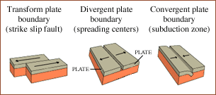
Types of plate boundaries
There are 3 types of plate boundaries, depending on how the plates move relative to each other:
Divergent boundaries occur where two plates move apart from each other. This happens at the mid-ocean ridges, where seafloor spreading and volcanic activity continuously add new oceanic crust to the oceanic plates on both sides. Examples are the Mid-Atlantic Ridge and East Pacific Rise. Divergent boundaries on continents are more rare, but also exist. An example is the East African rift. If the process of rifting on a continent continues long enough, it can break up the continent and form a new oceanic basin separating the parts.
Convergent boundaries occur where two plates slide towards each other to form either a subduction zone (if one plate, normally an oceanic plate moves underneath the other) or a continental collision. Subduction zones include the boundaries of the Pacific plate (e.g. Western South America) where the dense oceanic lithosphere sinks beneath the less dense continental plates. Earthquakes trace path of downward-moving plate as it descends into asthenosphere. A deep-sea trench forms.
Transform boundaries occur where two lithospheric plates slide past each other along transform faults. Strong earthquakes can occur along these faults. The most famous example is the San Andreas Fault in California, where the Pacific and the North-American plates move along each other.
Plate tectonics and magma generation
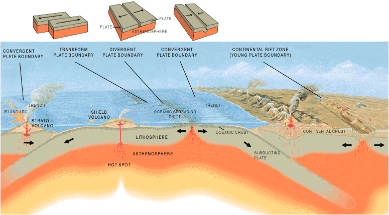
Volcanism at divergent and convergent plate margins (USGS)
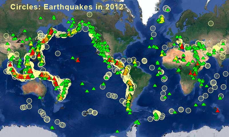
A connection between earthquakes and volcanic activity has probably been suspected since the earliest history of mankind. But it is the theory of Plate Tectonics to allow explaining the deeper relationship between the two phenomena and explaining both of them in a single unifying theory.
Melting the mantle
Most magmas (molten rock) originate directly from the mantle. The solid crust would generally be too cold to produce melts. Only if it is heated, e.g. by magma with much higher temperatures intruding from underneath, small amounts of crust can be melted as well.
Pressure keeps (most of) the mantle solidWithin the hot mantle, however, there is a different problem to produce magmas: pressure. (Partial) melting of mantle rock is only possible if the temperature's tendency to melt rock exceeds the opposing effect of pressure. This constellation is only given in the uppermost layers of the mantle, beneath the lithosphere, in a zone called the
asthenosphere (Greek: "asthenos" = weak). The asthenosphere lies between about 100 km and 35 km depth and is composed of hot, weak material that may contain a few percent of partial melts or is near the point to produce melts.
Magma must rise to the surface to make a volcano
The normal amount of melt that may be present in the asthenosphere under a normal plate is obviously too small to produce volcanoes on the surface (otherwise there would be volcanoes all over) and is in equilibrium with its surroundings. Not only larger amounts of melt are needed to produce volcanoes on the surface, but also suitable passageways, in forms of cracks and fractures through the rigid crust must exist or be created by the pressure of larger amounts of magma. In the interior of plates, this condition is usually not given. On the other hand, there are 3(4) distinct tectonic environments where magmas are formed in larger quantities and where volcanoes occur:
- on divergent margins:
at mid-ocean ridges and in continental rift valleys- on convergent margins:
subduction zones
- in the middle of plates:
intraplate (hot spot) volcanism