(stratovolcano 4267 m / 13,999 ft)
Aliso volcano is a newly discovered active stratovolcano complex at the eastern foot of the Ecuadorian Andes, east of Antisana volcano and SW of the town of Baeza. It contains andesitic lava flows, lava domes and pyroclastic flow deposits. Aliso volcano is dormant and has been la... [
more info]
(caldera 5321 m / 17,457 ft)
El Altar is an extinct stratovolcano on the western side of Sangay National Park in Ecuador, 170 km south of Quito. Altar was last active about 2 million years ago and contains a caldera open to the west, which contains a lake.
A large rockslide caused fatalities in 2000. ... [
more info]
(stratovolcano 5753 m / 18,874 ft)
Antisana volcano is a large, glacier covered stratovolcano 50 km SE Quito, Ecuador. It is located on the eastern margin of the Cordillera Real, at the latitude where the volcanic chain of the Northern Volcanic Zone is widest. Antisana is one of the largest volcanoes and highest p... [
more info]
(stratovolcano 4463 m / 14,642 ft)
Atacazo volcano is part of the Atacazo–Ninahuilca Volcanic Complex in the Western Cordillera of Ecuador and located 10 km southwest of the capital of Ecuarod, Quito.
The andesitic Atacazo stratovolcano is a successor of the older La Carcacha stratovolcano. It was built abov... [
more info]
(Stratovolcano 5102 m / 16739 ft)
[
more info]
(Stratovolcano 3501 m / 11486 ft)
[
more info]
(stratovolcano 5790 m / 18,996 ft)
Nevado Cayambe is a massive volcanic complex in northern Ecuador, 60 km NE of the city of Quito and only 15 km E of the 20,000 inhabitants city of Cayambe. The equator passes through its southern flank. The andesitic-dacitic volcano is located on the isolated western edge of the ... [
more info]
(Shield volcano 1640 m / 5,381 ft)
Cerro Azul volcano a basaltic shield volcano on the SW part of Isabela Island in the Galápagos Islands. It has the same name as
Cerro Azul volcano in Chile, meaning "Blue Mountain" in Spanish.
Cerro Azul is one of the most active volcanoes of ... [
more info]
(stratovolcano 4445 m / 14,583 ft)
Cerro Negro de Mayasquer (Chiles-Cerro Negro volcano) is an andesitic to dacitic stratovolcano on the Colombia-Ecuador border. It contains a caldera open to the west.
An historical eruption reported in 1936 is probably false and may have been from Reventador volcano. Solfat... [
more info]
(Stratovolcano 4348 m / 14265 ft)
[
more info]
(stratovolcano 4643 m / 15,233 ft)
Chacana is an active stratovolcano 30 km SE of Quito, Ecuador. The volcano is one of the largest rhyolitic centers of the northern Andes and contains a large 32 km long and 24 km wide eroded caldera.
Historic activity consisted of lava flows in the 18th century. [
more info]
(stratovolcano 4106 m / 13,471 ft)
Chachimbiro volcano is a large volcanic complex 25 km NW of the city of Ibarra in northern Ecuador.
There are no historic eruptions. The most recent activity took place from the Pitzantzi lava dome and produced a wide-spread ash deposit that extends NW. [
more info]
(Stratovolcano 3967 m / 13015 ft)
[
more info]
(stratovolcano 6310 m / 20,702 ft)
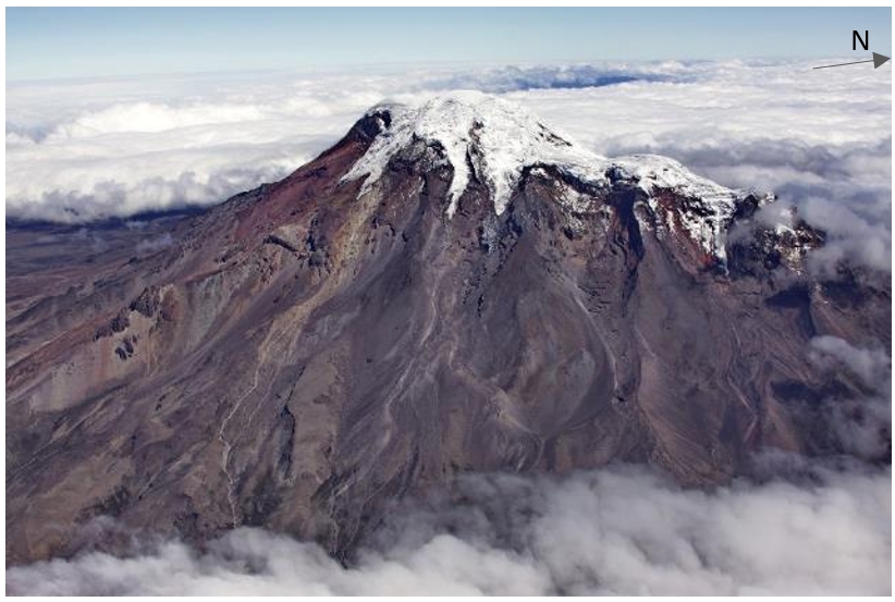
View of Chimborazo volcano from the west (Photo: P. Ramón IG/EPN)
Chimborazo volcano is Ecuador's highest active volcano and the highest in the Northern Andean Volcanic Zone. The massive, ice-capped stratovolcano lies at the southwest end of the main Ecuadorian volcanic arc, the so-called "Avenida de los Volcanes" ("Avenue of Volcanoes") and is... [
more info]
(Stratovolcano 4786 m / 15702 ft)
[
more info]
(Stratovolcano 4939 m / 16204 ft)
[
more info]
(stratovolcano 5911 m / 19,393 ft)
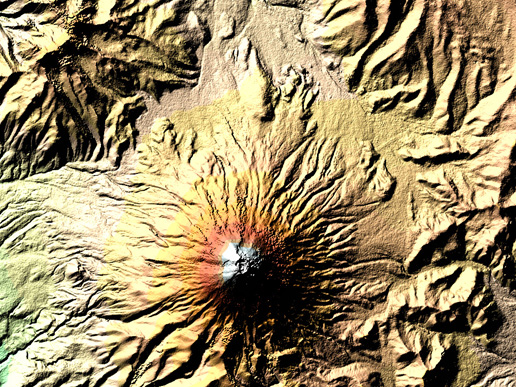
The digital elevation model of Cotopaxi volcano acquired by SRTM. With its resolution of 25 m x 25 m, is so rich in detail that you can even make out an inner crater with a diameter of 120 m by 250 m inside the outer crater (800 m x 650 m). Blue and green correspond to the lowest elevations in the image, while beige, orange, red, and white represent increasing elevations. (Image Credit: NASA Earth Observatory)
Cotopaxi is one of South America's most famous volcanoes and one of its most active ones. With its 5911 m it also ranks among the world's highest active volcanoes (26th highest).
The majestic, snow covered symmetrical stratovolcano is located on the Eastern Cordillera of t... [
more info]
(caldera 3246 m / 10,649 ft)
Cuicocha volcano is a beautiful caldera in northern Ecuador 100 km north of Quito. The volcano has a 3 km wide lake filled caldera and sits at the feet of the sharp-peaked (extinct) Cotacachi stratovolcano.
There are gas emissions from several locations in the caldera lake... [
more info]
(Stratovolcano 3989 m / 13087 ft)
[
more info]
(stratovolcano 4784 m / 15,695 feet)
Guagua Pichincha is one of Ecuador's most active volcanoes. The stratovolcano is part of a complex that rises immediately west of the capital Quito, at only 8 km distance from the city center. 3 major explosive eruptions have occurred at Guagua Pichincha in the past 2000 years, t... [
more info]
(Stratovolcano 4430 m / 14534 ft)
[
more info]
(Stratovolcano 3870 m / 12697 ft)
[
more info]
(Stratovolcano 3185 m / 10449 ft)
[
more info]
(stratovolcano 5248 m / 17,218 ft)
Illiniza is a glacier-covered stratovolcano 55 km southwest of Quito, Ecuador. It has 2 peaks 1.8 km apart, Illiniza Sur (5248 m) and Illiniza Norte (5126 m) and forms a prominent landmark west of the Interandean valley.
Iliniza Norte is the remnant of the older volcanic ed... [
more info]
(compound volcano 4609 m / 15,121 ft)
Imbabura volcano in northern Ecuador is located above the scenic Laguna de San Pablo in the Interandean valley 60 km north of the capital Quito.
Eruptions at Imbabura volcano generated pyroclastic flows that extended northeast. A large dome collapse of Huarmi Imbabura about... [
more info]
(cinder cones 3336 m / 10,945 ft)
Licto volcano is a group of cinder cones along the Río Chambo about 25 km SE of the city of Riobamba and just north of the town of Licto, Ecuador. It is the southernmost young volcanic area in the Interandean valley of Ecuador.
The precise age of the cones is unknown, but b... [
more info]
(Stratovolcano 3732 m / 12244 ft)
[
more info]
(stratovolcano 4263 m / 13,986 ft)
Volcán Mojanda is one of the largest volcanoes of Ecuador's northern Interandean Depression. It is located SW of the historic town of Otavalo. It is a twin volcano and consists of 2 neighboring active stratovolcanoes (Mojanda and Fuya Fuya).
Large-scale debris avalanches ha... [
more info]
(Stratovolcano 4076 m / 13373 ft)
[
more info]
(stratovolcano 3482 m / 11,424 ft)
Pan de Azucar is a probably extinct stratovolcano in a hardly accessible area in the Amazonian jungle between Sumaco and Reventador volcanoes. It has been active around 1 million years ago and produced lava from basaltic to andesitic in composition. [
more info]
(Stratovolcano 4199 m / 13776 ft)
[
more info]
(Stratovolcano 4254 m / 13957 ft)
[
more info]
(caldera 3356 m / 11,010 ft)
Pululahua is cut by a caldera, which is 5 km wide and irregularly shaped and covers an area of 19 km2. The caldera formed about 2450 year ago after a series of violent explosive eruptions. It is partially filled by post-caldera dacite lava domes, which rise to up to 480 m above t... [
more info]
(Pyroclastic cone(s) 1072 m / 3517 ft)
[
more info]
(caldera 3914 m / 12,841 ft)
Quilotoa volcano is a small 3 km wide caldera about 80 km SSW of Quito. It is the westernmost of Ecuador's Andean volcanoes. The caldera is the truncated remnant of a dacitic stratovolcano. It has steep inner walls which rise 400 m above the surface of a 240 m deep lake.
Th... [
more info]
(Stratovolcano 3562 m (11,686 ft))
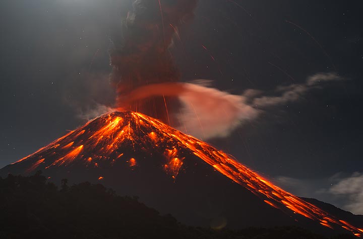
Vulcanian explosion at Reventador volcano in Jan 2020
Reventador, a 3562 m high stratovolcano, is one of Ecuador's most active volcanoes. [
more info]
(Stratovolcano 4712 m / 15459 ft)
[
more info]
(Stratovolcano 4153 m / 13625 ft)
[
more info]
(Stratovolcano 5230 m (17,159 ft))
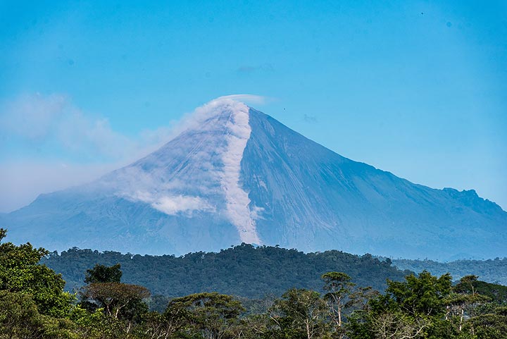
Sangay volcano during an eruption in Jan 2020 seen from Macas
Sangay volcano is one of the highest active volcanoes in the world and one of Ecuador's most active ones. Located isolated east of the Andean crest, with it's perfect steep cone shape and glacier-covered top, it towers majestically at 5230 m high above the Amazonian rainforest. [
more info]
(Stratovolcano 4893 m / 16053 ft)
[
more info]
(stratovolcano 3955 m / 12,976 ft)
Volcán el Soche is a small stratovolcano in northern Ecuador near the border with Colombia west of Río Chingual. A small village, La Bonita, is located on the southern side of the volcano.
The volcano has a summit caldera open towards the east. There are no historic erupti... [
more info]
(stratovolcano 3990 m / 13,090 ft)
Sumaco is an active stratovolcano east of Antisana, ca. 100 km east of Quito. It is an isolated mountain about 50 km east of the main volcanic range and rises 2800 m above the western Amazon basin. The volcano contains a 300 x 400 m wide summit crater with a central cone inside. ... [
more info]
(Stratovolcano 5023 m (16,479 ft))
Tungurahua is one of South America's most active volcanoes. Since 2000, a new lava dome has been growing in its summit crater. Tungurahua's activity has been characterized by frequent powerful ash explosions, producing ash plumes of several kilometers height as well as dangerous ... [
more info]
(Stratovolcano 4535 m / 14879 ft)
[
more info]


