Kontakt | RSS | EN | DE | EL | ES | FR | IT | RU

Vulkane in der Antarktis (47)

Adare Peninsula | Andrus | Argo Point | Beaufort Island | Beethoven Peninsula | Berlin | Black Island | Brabant Island | Bridgeman Island | Bristol Island | Buckle Island | Bursey | Crary Group | Deception Island | Discovery | Erebus | Franklin Island | Gaussberg | Hudson Mountains | Hut Point Peninsula | Livingston-Greenwich Islands | Mason Spurr | Melbourne | Mount Rittmann | Mt. Morning | Murphy | Obiglio | Paulet | Penguin Island | Peter I Island | Royal Society Range | Seal Nunataks Group | Shepard Island | Siple | Sturge Island | Tabarin Peninsula | Takahe | Taylor Valley | Terror | The Pleiades | Toney Mountain | Transantarctic Mountain Foothills | Unnamed 73.45°S/164.58°E | Unnamed 76.83°S/163.00°E | Waesche | White Island | Young Island
[kleiner] [größer]

Volcano list

Adare Peninsula

(Shield(s) 2083 m / 6834 ft)
[mehr Infos]

Andrus

(Shield volcanoes 2978 m / 9,770 ft)
[mehr Infos]

Argo Point

(Pyroclastic cone 360 m / 1181 ft)
[mehr Infos]

Beaufort Island

(Stratovolcano 740 m / 2428 ft)
[mehr Infos]

Beethoven Peninsula

(Volcanic field 1050 m / 3445 ft)
[mehr Infos]

Berlin

(Shield volcanoes 3478 m / 11,411 ft)
[mehr Infos]

Black Island

(Pyroclastic cone(s) 1041 m / 3415 ft)
[mehr Infos]

Brabant Island

(Volcanic field 2522 m / 8274 ft)
[mehr Infos]

Bridgeman Island

(Stratovolcano 240 m / 787 ft)
[mehr Infos]

Bristol Island

(Stratovolcano 1100 m / 3,609 ft)
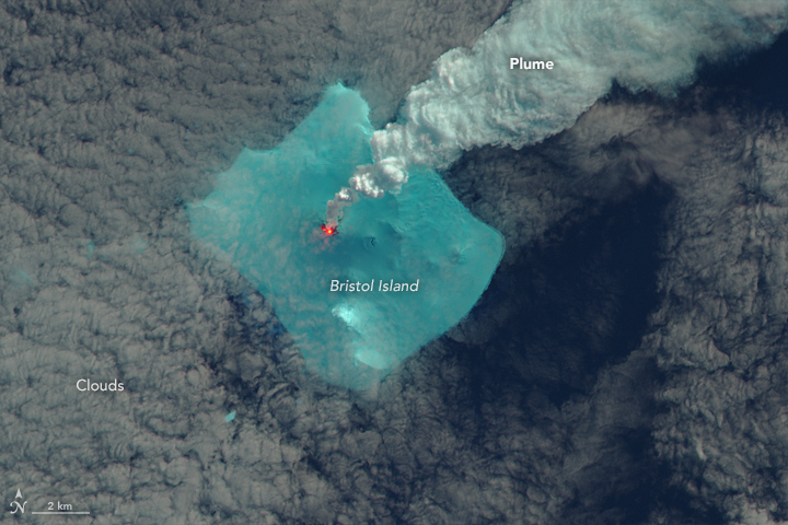
NASA Earth Observatory image of Bristol Island on 24 April 2016 by Jesse Allen, using Landsat data from the U.S. Geological Survey.
Bristol volcano forms an ice-capped, roughly rectangular island 12x14 km wide and is one of the largest of the South Sandwich Islands chain. Its highest peak is 1100 meters (3,609 feet) above sea level.
Although very active, it is one of the least studied and least known v... [mehr Infos]

Buckle Island

(Stratovolcano 1239 m / 4,065 ft)
[mehr Infos]

Bursey

(Shield(s) 2787 m / 9144 ft)
[mehr Infos]

Crary Group

(Shield(s) 3654 m / 11988 ft)
[mehr Infos]

Deception Island

(caldera 576 m / 1,890 ft)
Deception Island is a 14 km wide, ring-shaped volcanic island at the south-western end of the South Shetland Islands, NE of Graham Land Peninsul.
It is one of the most well-known active volcanoes of the Antarctic region.
Deception Island is a sea-filled caldera with a... [mehr Infos]

Discovery

(Stratovolcano 2578 m / 8458 ft)
[mehr Infos]

Erebus

(stratovolcano 3794 m / 12,447 ft)
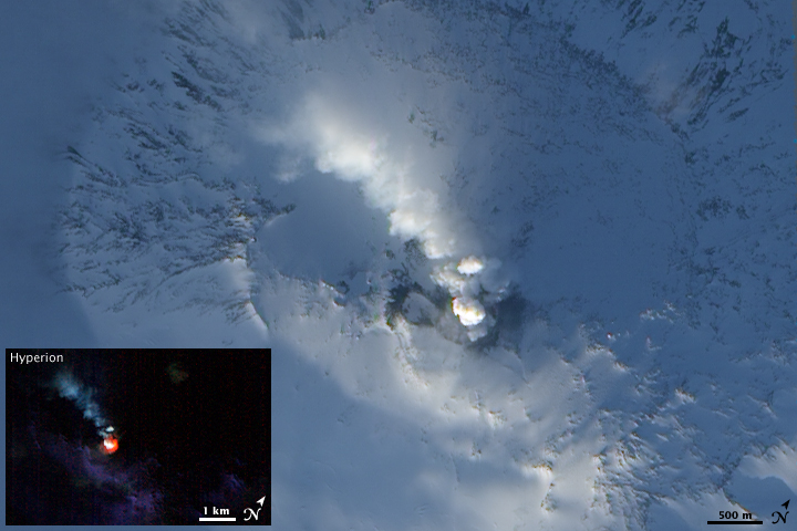
NASA Earth Observatory photo of Mt Erebus on 6 February 2009
Mount Erebus stratovolcano is the highest and most active volcano of Antarctica, one of the Volcanic Seven Summits, and the largest of 4 volcanoes that form the roughly triangular Ross Island (Mt Erebus, and the extinct Mt. Bird to the north, Mt. Terra Nova and Mt. Terror to the ... [mehr Infos]

Franklin Island

(Shield 247 m / 810 ft)
[mehr Infos]

Gaussberg

(Cone 370 m / 1214 ft)
[mehr Infos]

Hudson Mountains

(Stratovolcanoes 749 m / 2,457 ft)
[mehr Infos]

Hut Point Peninsula

(Pyroclastic cone(s) 431 m / 1414 ft)
[mehr Infos]

Livingston-Greenwich Islands

(Tuff cone(s) 530 m / 1739 ft)
[mehr Infos]

Mason Spurr

(Lava dome(s) unknown)
[mehr Infos]

Melbourne

(Stratovolcano 2732 m / 8,963 ft)
[mehr Infos]

Mount Rittmann

(Shield volcano 2600 m / 8,530 ft)
[mehr Infos]

Mt. Morning

(Shield volcano 2723 m / 8,934 ft)
[mehr Infos]

Murphy

(Shield 2703 m / 8868 ft)
[mehr Infos]

Obiglio

(Pyroclastic cone 488 m / 1601 ft)
[mehr Infos]

Paulet

(Cinder cone 353 m / 1,158 ft)
[mehr Infos]

Penguin Island

(Stratovolcano 180 m / 591 ft)
[mehr Infos]

Peter I Island

(Shield volcano 1640 m / 5,381 ft)
[mehr Infos]

Royal Society Range

(Cinder cones 3000 m / 9,842 ft)
[mehr Infos]

Seal Nunataks Group

(Pyroclastic cones 368 m / 1,207 ft)
[mehr Infos]

Shepard Island

(Tuff cone(s) 487 m / 1598 ft)
[mehr Infos]

Siple

(shield volcano 3110 m / 10,203 ft)
Mount Siple volcano is one of the largest active volcanoes in Antarctica. It is a young shield volcano in the NW of Siple Island, Hobbs Coast, Antarctica. Mount Siple forms an island off the Pacific coast of Antarctica's Marie Byrd Land and is separated from the coast by the Getz... [mehr Infos]

Sturge Island

(Stratovolcano 1167 m / 3,829 ft)
[mehr Infos]

Tabarin Peninsula

(Shield? 730 m / 2395 ft)
[mehr Infos]

Takahe

(Shield volcano 3460 m / 11,352 ft)
[mehr Infos]

Taylor Valley

(Pyroclastic cone(s) 1489 m / 4885 ft)
[mehr Infos]

Terror

(Shield 3262 m / 10702 ft)
[mehr Infos]

The Pleiades

(Stratovolcano 3040 m / 9,974 ft)
[mehr Infos]

Toney Mountain

(Shield volcano 3595 m / 11,794 ft)
[mehr Infos]

Unnamed 73.45°S/164.58°E

(Scoria cones 2987 m / 9,800 ft)
[mehr Infos]

Unnamed 76.83°S/163.00°E

(Submarine volcano -500 m / - 1,640 ft)
[mehr Infos]

Waesche

(Shield volcanoes 3292 m / 10,800 ft)
[mehr Infos]

White Island

(Shield(s) 762 m / 2500 ft)
[mehr Infos]

Young Island

(Stratovolcano 1340 m / 4,396 ft)
[mehr Infos]
News
Mi, 3. Apr 2024, 02:56

White Island volcano (New Zealand): continuous emissions of steam and gas at low levels persist

Grey-colored 2019 Crater with geysering captured on 20 March (image: GeoNet New Zealand)
The most recent airborne gas measurements from 26 March indicate a slight uptick in sulfur dioxide (SO2) levels compared to measurements taken a month earlier on 29 February 29. Although there has been a slight upward trajectory in SO2 emissions over the past year, the overall emissions of the key monitored gases - carbon dioxide (CO2), hydrogen sulphide (H2S), and SO2 - remain at low to moderate levels. ... Read all
Mo, 8. Dez 2014, 09:27

Erebus volcano (Antarctica): elevated activity, explosions

Seismic recording from Mt. Erebus on 5 Dec 2014
The Mount Erebus Volcano Observatory (MEVO) reported yesterday that "it has been an active time for the last 24 hours. There were 6 significant eruptions which show up nicely on the MACZ (short period single vertical component) seismometer. Read all
App herunterladen
Volcanoes & Earthquakes - new app for Android
Android | iOS-Version

Mehr auf VolcanoDiscovery

Warum gibt es Werbung auf dieser Seite?

Unterstützen Sie unsere Arbeit!

Diese Webseite und die dazugehörigen Apps und Tools instandzuhalten und kostenlos Nachrichten zu Vulkanen, Erdbeben und anderen Themen bereitzustellen, verschlingt enorm viel Zeit und auch Geld.
Wenn Sie die Infos mögen und uns in der Arbeit dazu unterstützen wollen, würden wir uns über eine Spende (über PayPal oder mit Kreditkarte) sehr freuen.
Online Zahlung (Kreditkarte)
Damit können wir Ihnen auch in Zukunft neue Features entwickeln und Bestehende laufend verbessern.Vielen Dank!
Sources: VolcanoDiscovery / VolcanoAdventures and other sources as noted.
Use of material: Most text and images on our websites are owned by us. Re-use is generally not permitted without authorization. Contact us for licensing rights.
Volcanoes & Earthquakes
VolcanoDiscovery Home
Vulkane | Erdbeben | Fotos | News | App
Adventure & Study Travel
Reisen zu Vulkanen und Vulkangebieten: Wanderreisen, Studienreisen, Fotoreisen
Tours & Dates | FAQ | About us
Get our newsletter!
Company info
Kontakt | Impressum | AGB
Follow us
Follow us on facebook Follow us on Instagram Follow us on Twitter Visit our Youtube channel
EN | DE | EL | ES | FR | IT | RU
VolcanoDiscovery GmbH, Germany, Reg. nr.: HRB 103744, EU Tax Id: DE 297 465 123 owned and created by
Dr. Tom Pfeiffer, volcanologist, volcano photographer, tour organizer member of
IAVCEI
IAVCEI
Vulkanologische Gesellschaft
Volcanological Society
Ecotourism Greece
Ecotourism Greece
RUV insurance
Insured by R+V
VolcanoDiscovery © 2004- All Rights Reserved | Datenschutz