Ata caldera Volcano
Updated: 24. Apr. 2024 12:51 GMT -
caldera 924 m / 3031 ft
Kyushu Island, Japan, 31.22°N / 130.57°E
Aktueller Status: normal / ruhend (1 von 5)
Kyushu Island, Japan, 31.22°N / 130.57°E
Aktueller Status: normal / ruhend (1 von 5)
Ata is one of the major active caldera systems of Kyushu, located south of the Kagoshima Bay. It had a massive "super-volcano"-style eruption 40,000 years ago, and contains the active Ibusuki volcanic field as well as famous Kaimondake stratovolcano towering above the southern tip of the island.
[smaller] [larger]
Ausbrüche des Ata caldera: 885 AD
Letzte Erdbeben in der Nähe
| Uhrzeit | Mag. / Tiefe | Entfernung / Ort | |||
| 22. Apr. 04:54 (GMT +9) | 2.6 184 km | Info | |||
| Freitag, 19. April 2024 GMT (1 Beben) | |||||
| 19. Apr. 17:52 (GMT +9) | 3.0 163 km | 21 km westlich | Info | ||
| Samstag, 13. April 2024 GMT (1 Beben) | |||||
| 13. Apr. 19:57 (GMT +9) | 2.5 136 km | Info | |||
| Freitag, 12. April 2024 GMT (1 Beben) | |||||
| 13. Apr. 01:00 (GMT +9) | 4.0 147 km | 13 km westlich | Info | ||
| Donnerstag, 11. April 2024 GMT (1 Beben) | |||||
| 11. Apr. 17:10 (GMT +9) | 3.9 155 km | 22 km südwestlich | Info | ||
Beschreibung
The submerged 15 x 25 km Ata caldera under Kagoshima Bay is one of several large calderas in southern Kyushu and the source of major pyroclastic flows associated with its formation more than 40,000 years ago.The National Catalogue of the Active Volcanoes of Japan (JMA, 2013) included features of the Ibusuki volcanic field as part of the Ata post-caldera system. That area consists of numerous central cones and maars, the 4.5-km-wide Ikeda caldera, and Kaimondake stratovolcano. The symmetrical andesitic Kaimondake is the most prominent feature, and is capped by a lava dome. Ibusuki has been very active during the Holocene, forming the Ikeda caldera about 4,600 years ago, numerous maars and lava domes. Kaimondake formed during the last 4,000 years, from which all eruptive activity has occurred after about 2,650 years ago. Its last eruption took place in the 9th century. While listed as features of the Ata caldera, JMA (2013) simultaneously listed Kaimondake and the combination of Ikeda and Yamagawa as distinct volcanoes.
Ata caldera Volcano Photos
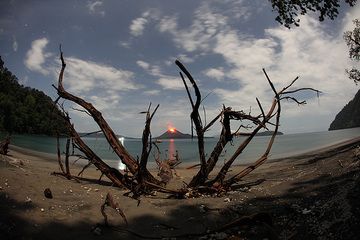
Ein großer Baum ist vor kurzem am Strand umgestürzt. Seine Wurzeln rahmen den Kegel des Krakatau bizarr ein. (Photo: Tom Pfeiffer)
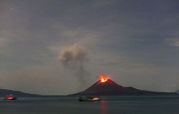
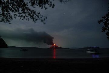
Fischerboote in der Kaldera vor dem ausbrechenden Krakatau am Abend des 4. Juni 09. (Photo: Tom Pfeiffer)
Wide-angle view of the caldera of Krakatau; our boat drifts into the picture (r). (Photo: Tom Pfeiffer)

Vollmond, die Caldera und ein heller Ausbruch des Anak Krakatau. (Photo: Tom Pfeiffer)
Latest satellite images