Volcano list
Bachelor
(stratovolcano 2763 m / 9,065 ft)The chain is aligned N-S and consists of the main volcano of Mt Bachelor itself, cinder cones, small shield... [mehr Infos]
Bailey
(Shield 2551 m / 8369 ft)Belknap
(shield volcanoes 2095 m / 6,873 ft)Big Bunchgrass
(Pyroclastic cone 2024 m / 6640 ft)Black Butte
(Stratovolcano 1962 m / 6437 ft)Black Crater
(Shield(s) 2210 m / 7251 ft)Blue Lake Crater
(stratovolcano 1230 m / 4,035 ft)Boring Lava
(Volcanic field 1236 m / 4055 ft)Broken Top
(stratovolcano 663 m / 2,175 ft )Brown Mountain
(Shield 2228 m / 7310 ft)Cappy Mountain
(Stratovolcano 2253 m / 7392 ft)China Hat-East Butte
(Lava dome(s) 2004 m / 6575 ft)Cinnamon Butte
(cinder cones 1956 m / 6,417 ft)Cowhorn Mountain
(Shield(s) 2336 m / 7664 ft)Crater Lake
(caldera 2487 m / 8,159 feet)Cultus Mountain
(Shield 2060 m / 6759 ft)Cupit Mary Mountain
(Shield 1879 m / 6165 ft)Davis Lake
(volcanic field 2163 m / 7,096 ft)Defiance
(Shield 1512 m / 4961 ft)Devils Garden
(volcanic field 1698 m / 5,571 ft)Diamond Craters
(volcanic field 1435 m / 4,708 ft)Diamond Craters were named after the Diamond Ranch, established i... [mehr Infos]
Diamond Peak
(Shield 2665 m / 8743 ft)Fort Rock Volcanic Field
(Maar(s) 1712 m / 5617 ft)Four Craters
(volcanic field 1501 m / 4,924 ft)The Four Craters lava field contains 4 spatter cones along a 4-km-long NW-SE-trendin... [mehr Infos]
Four Craters Lava Field
(Volcanic field 1501 m / 4925 ft)Fuji Mountain
(Shield(s) 2177 m / 7142 ft)Goose Nest
(Shield 2213 m / 7260 ft)Imagination Peak
(Pyroclastic cone 1986 m / 6516 ft)Irish Mountain
(Shield 2101 m / 6893 ft)Jackies Butte
(Volcanic field 1418 m / 4652 ft)Jefferson
(stratovolcano 3199 m / 10,495 ft)Jordan Craters
(volcanic field 1473 m / 4,833 ft)Lava Butte
(Shield(s) 1447 m / 4747 ft)Lava Mountain
(Volcanic field 1711 m / 5614 ft)Lost Lake Butte
(Shield 1362 m / 4469 ft)Maiden Peak
(Shield(s) 2383 m / 7818 ft)McLoughlin
(Stratovolcano 2894 m / 9495 ft)Mount Hood
(stratovolcano 3426 m / 11,240 ft)Andesite-dacite lava domes form the glacially... [mehr Infos]
Mount Washington
(shield volcano 2376 m / 7,794 ft)Mountain Lakes
(Volcanic field 2502 m / 8209 ft)Newberry
(shield volcano, caldera 2434 m / 7,985 ft)The volcano las... [mehr Infos]
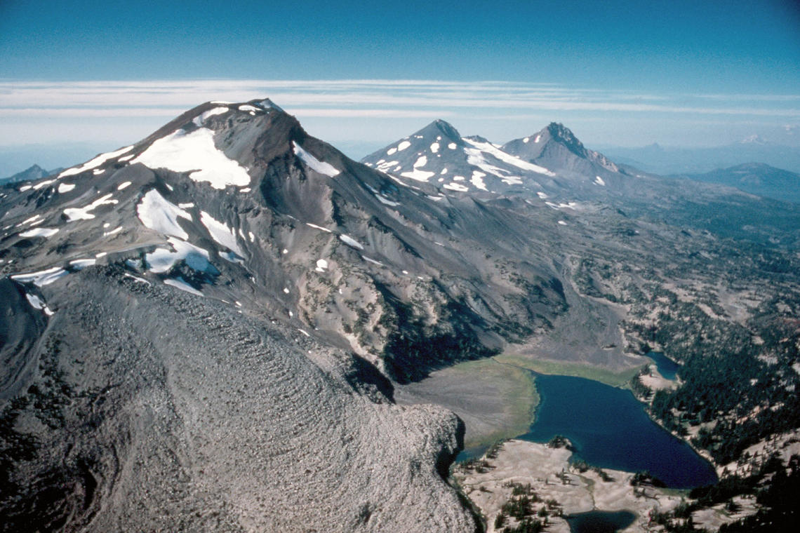
North Sister
(complex volcano 3074 m / 10,085 ft)North Sister is the glacially eroded remnant of a andesitic-dacitic stratovolcano, expos... [mehr Infos]
Olallie Butte
(Shield(s) 2199 m / 7215 ft)Pelican Butte
(Shield 2449 m / 8035 ft)Quartz Mountain
(Lava dome 1885 m / 6184 ft)Red Top Mountain
(Shield(s) 2118 m / 6949 ft)Saddle Butte
(Volcanic field 1700 m / 5577 ft)Sand Mountain
(cinder cones 1664 m / 5,459 ft)Scott Mountain
(Shield 1864 m / 6115 ft)Silver Creek
(Volcanic field 1375 m / 4511 ft)South Sister
(complex volcano 3157 m / 10,357 ft)Sprague River Valley
(Shield(s) 1300 m / 4265 ft)Squaw Ridge
(lava field, shield volcano )Taylor Butte
(Shield 1775 m / 5823 ft)Thielsen
(Shield 2799 m / 9183 ft)Three Fingered Jack
(Shield(s) 2390 m / 7841 ft)Three Sisters
(Complex volcano, cinder cones, shields, fissure vents 3159 m / 10364 ft)Volcanic activity occurred frequently from various vents... [mehr Infos]