Savai'i Volcano
Updated: 24. Apr. 2024 05:40 GMT -
Shield volcano 1858 m / 6,096 ft
Samoa, Samoan Islands, -13.61°S / -172.53°W
Aktueller Status: normal / ruhend (1 von 5)
Samoa, Samoan Islands, -13.61°S / -172.53°W
Aktueller Status: normal / ruhend (1 von 5)
[smaller] [larger]
Ausbrüche des Savai'i: 1911
Letzte Erdbeben in der Nähe
| Uhrzeit | Mag. / Tiefe | Entfernung / Ort | |||
Beschreibung
Savai'i, the largest and highest of the Samoan islands, consists of a massive basaltic shield volcano constructed along a WNW-ESE-trending rift zone that splits into two rifts on the east side of the 75-km-long, oval-shaped island. Pliocene and Pleistocene shield formation was followed by stream and marine erosion, partial submergence, and growth of coral reefs. Late-stage Pleistocene and Holocene eruptions produced voluminous lava flows that partially buried fringing reefs. Numerous cinder cones and lava cones dot the broad crest of Savai'i, which has a low-angle, dome-like profile and reaches an elevation of 1858 m. Additional cones occur on the north-central flank, and a large number are found in the south-central part of the island. Three eruptions, including two in the 20th century, occurred in historical time, and produced voluminous lava flows that reached the northern coast along broad fronts up to about 15 km wide, destroying several villages and overtopping fringing reefs.---
Smithsonian / GVP volcano information
Savai'i Volcano Photos
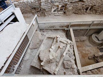
Aufgrund der Erfahrungen mit dem römischen Pompeji wussten die Archäologen, dass sie alle Löcher mit Gips füllen sollten. In diesem Fall hatten sie Erfolg und ein prähist...
Latest satellite images