Spurr Volcano
Updated: 20. Apr. 2024 00:40 GMT -
stratovolcano 3374 m / 11,070 ft
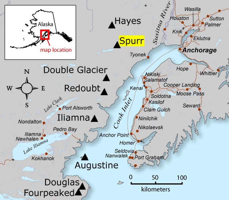
Cook Inlet, SW Alaska, 61.3°N / -152.25°W
Aktueller Status: normal / ruhend (1 von 5)
Cook Inlet, SW Alaska, 61.3°N / -152.25°W
Aktueller Status: normal / ruhend (1 von 5)
Last update: 5 Apr 2024 (monitoring stations have been restored, allowing for real-time monitoring once again)
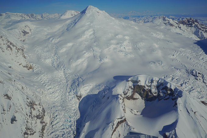
Mt Spurr volcano is the highest volcano in the Aleutian Volcanic Arc. the glacier-covered stratovolcano is located 130 km west of Anchorage and NE of Chakachamna Lake.
Mt Spurr had a violent sub-plinian eruption in 1992 and a large eruption in 1953, both ranking at VEI 4 and produced by Crater Peak, a small flank vent on the south side. No other historic eruptions have been documented.
[smaller] [larger]
Ausbrüche des Spurr: 1992 (Crater Peak), 1965 (?, Spurr), 1953 (Crater Peak)
tephrochronology and radiocarbon dated: 1650 ± 50 years, 3250 BC ?, 4050 BC ?, 5110 BC ± 100 years, 6050 BC
Letzte Erdbeben in der Nähe
| Uhrzeit | Mag. / Tiefe | Entfernung / Ort | |||
| 18. Apr. 00:44 (Anchorage) | 2.0 93 km | 21 km östlich | Info | ||
| Mittwoch, 10. April 2024 GMT (1 Beben) | |||||
| 10. Apr. 08:41 (Anchorage) | 2.1 122 km | 9.4 km südlich | Info | ||
| Donnerstag, 18. April 2024 GMT (1 Beben) | |||||
| 17. Apr. 16:25 (Anchorage) | 1.8 0 km | 2.4 km östlich | Info | ||
| Montag, 15. April 2024 GMT (1 Beben) | |||||
| 15. Apr. 11:44 (Anchorage) | 1.8 119 km | 19 km nördlich | Info | ||
| Montag, 8. April 2024 GMT (1 Beben) | |||||
| 8. Apr. 03:09 (Anchorage) | 1.8 81 km | 17 km östlich | Info | ||
| Freitag, 12. April 2024 GMT (1 Beben) | |||||
| 12. Apr. 05:31 (Anchorage) | 1.6 88 km | 21 km östlich | Info | ||
Beschreibung
The 3374-m-high summit of Mount Spurr, the highest volcano of the Aleutain arc, is a large lava dome constructed at the center of a roughly 5-km-wide horseshoe-shaped caldera that is open to the south.The caldera was formed by a late-Pleistocene or early Holocene debris avalanche and associated pyroclastic flows that destroyed an ancestral Spurr volcano. The debris avalanche traveled more than 25 km to the SE, and the resulting deposit contains blocks as large as 100 m in diameter. Several ice-carved post-caldera cones or lava domes lie in the center of the caldera. The youngest vent, 2309-m-high Crater Peak, formed at the breached southern end of the caldera and has been the source of about 40 identified Holocene tephra layers. Spurr's two historical eruptions, from Crater Peak in 1953 and 1992, deposited ash on the city of Anchorage.
---
from: Smithsonian / GVP Mt Spurr volcano information
Ausbrüche des Vulkans Spurr
1992 eruption
A large, subplinian eruption occurred in 1992 at Mt Spurr volcano. There were 3 main explosions, on 27 June, 18 August and 16-17 September. The eruption produced ash columns up to 13.5 km high and ashfall in several hundred km distance. ...mehr Infos
A large, subplinian eruption occurred in 1992 at Mt Spurr volcano. There were 3 main explosions, on 27 June, 18 August and 16-17 September. The eruption produced ash columns up to 13.5 km high and ashfall in several hundred km distance. ...mehr Infos
1953 eruption
A VEI 4 explosive eruption occurred at Crater Peak from 9-16 July 1953. It produced major ash fall (up to 6 mm in Anchorage) and lahars on the flanks and the base of the volcano.
A VEI 4 explosive eruption occurred at Crater Peak from 9-16 July 1953. It produced major ash fall (up to 6 mm in Anchorage) and lahars on the flanks and the base of the volcano.
Latest satellite images