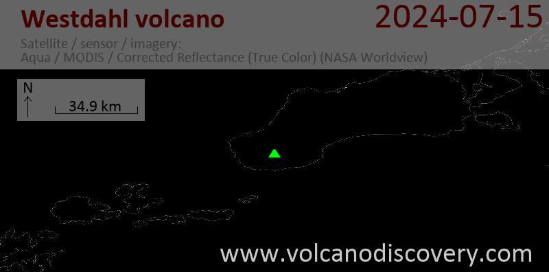
Kontakt | RSS | EN | DE | EL | ES | FR | IT | RU

Westdahl Volcano

Updated: 25. Apr. 2024 04:14 GMT -
Stratovolcano? 1654 m / 5,426 ft
United States, Aleutian Islands, 54.52°N / -164.65°W
Aktueller Status: normal / ruhend (1 von 5)
Last update: 22 Dez 2021 (Smithsonian / USGS Weekly Volcanic Activity Report)

[smaller] [larger]
Typische Aktivität: unspecified
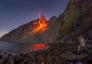
Ausbrüche des Westdahl: 1992 

Letzte Erdbeben in der Nähe

No recent earthquakes
UhrzeitMag. / TiefeEntfernung / Ort

Beschreibung

Westdahl is a broad, 1654-m-high glacier-covered volcano occupying the SW end of Unimak Island. Two peaks protrude from the summit plateau, and a new crater formed in 1978 cuts the summit icecap. The broad volcano has a somewhat of a shield-like morphology and forms one of the largest volcanoes of the Aleutian Islands. The sharp-topped, conical Pogromni stratovolcano lies 5 km north of Westdahl. Pogromni rises to 2002 m, several hundred meters higher than Westdahl, but is moderately glacially dissected and presumably older. Many satellitic cones of postglacial age are located along a NW-SE line cutting across the summit of Westdahl. Some of the historical eruptions attributed to the eroded Pogromni volcano may have originated instead from Westdahl (Miller et al. 1998). The first historical eruption of Westdahl occurred in 1795. An 8-km-long fissure extending east from the summit of Westdahl produced explosive eruptions and lava flows in 1991.
---
Smithsonian / GVP volcano information

Latest satellite images

westdahl satellite image sat1westdahl satellite image sat2
News
Mi, 14. Okt 2020, 06:00

Westdahl volcano (Fox Islands, USA) - Smithsonian / USGS Weekly Volcanic Activity Report for 14 October-20 October 2020 (Continuing Activity)

AVO reported that the seismic network at Westdahl has been re-established, again allowing seismic unrest at the volcano to be monitored. The Volcano Alert Level and Aviation Color Code were changed from Unassigned to Normal and Green, respectively, on 15 October. ... Read all

Auf dieser Seite:

App herunterladen
Volcanoes & Earthquakes - new app for Android
Android | iOS-Version

Mehr auf VolcanoDiscovery

Warum gibt es Werbung auf dieser Seite?

Unterstützen Sie unsere Arbeit!

Diese Webseite und die dazugehörigen Apps und Tools instandzuhalten und kostenlos Nachrichten zu Vulkanen, Erdbeben und anderen Themen bereitzustellen, verschlingt enorm viel Zeit und auch Geld.
Wenn Sie die Infos mögen und uns in der Arbeit dazu unterstützen wollen, würden wir uns über eine Spende (über PayPal oder mit Kreditkarte) sehr freuen.
Online Zahlung (Kreditkarte)
Damit können wir Ihnen auch in Zukunft neue Features entwickeln und Bestehende laufend verbessern.Vielen Dank!
Sources: VolcanoDiscovery / VolcanoAdventures and other sources as noted.
Use of material: Most text and images on our websites are owned by us. Re-use is generally not permitted without authorization. Contact us for licensing rights.
Volcanoes & Earthquakes
VolcanoDiscovery Home
Vulkane | Erdbeben | Fotos | News | App
Adventure & Study Travel
Reisen zu Vulkanen und Vulkangebieten: Wanderreisen, Studienreisen, Fotoreisen
Tours & Dates | FAQ | About us
Get our newsletter!
Company info
Kontakt | Impressum | AGB
Follow us
Follow us on facebook Follow us on Instagram Follow us on Twitter Visit our Youtube channel
EN | DE | EL | ES | FR | IT | RU
VolcanoDiscovery GmbH, Germany, Reg. nr.: HRB 103744, EU Tax Id: DE 297 465 123 owned and created by
Dr. Tom Pfeiffer, volcanologist, volcano photographer, tour organizer member of
IAVCEI
IAVCEI
Vulkanologische Gesellschaft
Volcanological Society
Ecotourism Greece
Ecotourism Greece
RUV insurance
Insured by R+V
VolcanoDiscovery © 2004- All Rights Reserved | Datenschutz - Cookie Einstellungen