Churchill Volcano
Updated: 25 Απριλίου 2024 15:44 GMT -
Stratovolcano 5005 m / 16,420 ft
United States, Eastern Alaska, 61.38°N / -141.75°W
Current status: normal or dormant (1 out of 5)
United States, Eastern Alaska, 61.38°N / -141.75°W
Current status: normal or dormant (1 out of 5)
Last update: 14 Mar 2022 (seismic swarm in mid July)
[smaller] [larger]
Churchill volcano eruptions: 800 AD ± 100 years
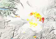
Latest nearby earthquakes
| Ώρα | Mag. / Βάθος | Απόσταση / Τοποθεσία | |||
| 16 Απρ 16:59 (Anchorage) | 1.0 15 km | 17 km βορειοανατολικά | Περ. | ||
| 16 Απρ 16:37 (Anchorage) | 1.0 20 km | 17 km βορειοανατολικά | Περ. | ||
| Κυριακή, 14 Απριλίου 2024 GMT (1 σεισμός) | |||||
| 14 Απρ 02:15 (Anchorage) | 1.8 0 km | 21 km βορειοανατολικά | Περ. | ||
| Σάββατο, 13 Απριλίου 2024 GMT (1 σεισμός) | |||||
| 12 Απρ 19:02 (Anchorage) | 1.6 15 km | 30 km βορειοανατολικά | Περ. | ||
Background
The Bona-Churchill massif in the St. Elias Mountains forms the highest Quaternary volcano in the United States. A 2.7 x 4.2 km wide caldera caps the summit of 4766-m-high Mount Churchill, which is now known to be the source of the White River Ash, produced during two of the largest explosive eruptions in North America during the past 2000 years (McGimsey et al. 1992). The 5005-m-high summit of Mount Bona lies 4 km across a high saddle from the younger Mount Churchill. The source vent of the widespread bilobate White River Ash deposit, which blankets more than 340,000 sq km of eastern Alaska and NW Canada, was initially thought to be a pumice mound that is mostly buried beneath the Klutlan Glacier NE of Churchill volcano. More recent work has revealed thick young pumice deposits mineralogically and chemically similar to the White River Ash deposits along the rim of the Mount Churchill caldera.---
Smithsonian / GVP volcano information
Latest satellite images