Coso Volcano
Καλιφόρνια (Καναδάς και ΗΠΑ (ηπειρωτική χώρα)), 36.03°N / -117.82°W
Current status: normal or dormant (1 out of 5)
The Coso volcanic field is located east of the Sierra Nevada Range at the western edge of the Basin and Range province, California. It consists of 38 old rhyolitic lava domes and basaltic cinder cones covering a 400 sq km area. volcano is located 200 km north of Los Angeles, California.
Eruptions in this area over the past 4 million years produced 35 km3 of lava, the youngest eruptions are probably from the basaltic Volcano Peak cinder cone and occurred more than 33,000 years ago.
Coso Geothermal System
There is geothermal activity in an ENE trending zone between Sugarloaf Mountain and the Coso Hot Springs. The Coso Hot Springs have fumaroles and intermittently active geysers. Fumaroles at Devils Kitchen and the adjacent Nicol area are located in an explosion crater surrounding a rhyolite lava dome.
Coso volcano eruptions: none during the past 10,000 years
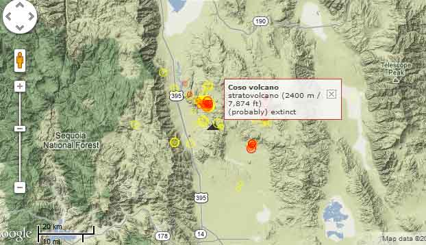
Latest nearby earthquakes
| Ώρα | Mag. / Βάθος | Απόσταση / Τοποθεσία | |||
| 16 Απρ 10:43 (Los Angeles) | 3.4 6 km | 11 km βορειοδυτικά | Περ. | ||
| 16 Απρ 08:25 (Los Angeles) | 3.2 5.8 km | 12 km βορειοδυτικά | Περ. | ||
| 16 Απρ 08:23 (Los Angeles) | 3.9 5.1 km | 12 km βορειοδυτικά | Περ. | ||
| 16 Απρ 08:23 (Los Angeles) | 3.4 4.4 km | 12 km βορειοδυτικά | Περ. | ||
| 16 Απρ 08:24 (Los Angeles) | 2.5 7.9 km | 11 km βορειοδυτικά | Περ. | ||
| Τετάρτη, 17 Απριλίου 2024 GMT (1 σεισμός) | |||||
| 16 Απρ 18:21 (Los Angeles) | 2.3 6.1 km | 12 km βορειοδυτικά | Περ. | ||
Background
The latest dated eruption formed the Volcano Peak basaltic cinder cone and lava flow and was Potassium-Argon dated at 39,000 +/- 33,000 years ago, but the youngest lava dome may even be younger than 11,000 years ago.---
Source: Smithsonian / GVP volcano information
Latest satellite images