Katla Volcano
Updated: 24 Απριλίου 2024 06:41 GMT -
subglacial volcano 1512 m / 4,961 ft
Southern Iceland, 63.63°N / -19.06°W
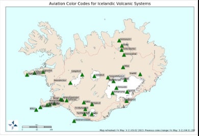
Current status: normal or dormant (1 out of 5)
Southern Iceland, 63.63°N / -19.06°W
Current status: normal or dormant (1 out of 5)
Last update: 10 May 2023 (Smithsonian / USGS Weekly Volcanic Activity Report)
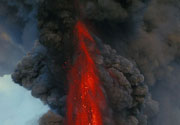
Katla volcano, located near the southern end of Iceland's eastern volcanic zone, is hidden beneath the Myrdalsjökull icecap. Katla is one of Iceland's most active and most dangerous volcanoes, infamous for its large eruptions happening on average every 50-100 year, causing devastating glacial floods (jökullhlaups).
In recent year, increased seismicity and inflation of Katla has been being measured. Katla, statistically due for a new eruption, is being very closely monitored and an eruption in a not too distant future would not come as a big surprise.
[smaller] [larger]
Katla volcano eruptions: 920 AD, 950 AD (?), 1150, 1177, 1245, 1262, 1311, 1357, 1416, 1440, 1450, 1500, 1580, 1612, 1625, 1660-61, 1721, 1755-56, 1823, 1860, 1918, 1955(?), 1999(?), 1918
Latest nearby earthquakes
| Ώρα | Mag. / Βάθος | Απόσταση / Τοποθεσία | |||
| 19 Απρ 15:18 (Reykjavik) | 1.9 0.1 km | 2.1 km βορειοδυτικά | Περ. | ||
| Τετάρτη, 10 Απριλίου 2024 GMT (1 σεισμός) | |||||
| 10 Απρ 21:01 (Reykjavik) | 1.7 0.2 km | 5.1 km νότια | Περ. | ||
| Σάββατο, 13 Απριλίου 2024 GMT (1 σεισμός) | |||||
| 13 Απρ 10:02 (Reykjavik) | 1.2 10.8 km | 17 km βορειοδυτικά | Περ. | ||
| Κυριακή, 21 Απριλίου 2024 GMT (1 σεισμός) | |||||
| 21 Απρ 04:31 (Reykjavik) | 1.1 3.4 km | 8.3 km νοτιοδυτικά | Περ. | ||
| Παρασκευή, 19 Απριλίου 2024 GMT (1 σεισμός) | |||||
| 19 Απρ 22:24 (Reykjavik) | 1.1 4.3 km | 6.4 km βορειοδυτικά | Περ. | ||
| Τετάρτη, 17 Απριλίου 2024 GMT (1 σεισμός) | |||||
| 17 Απρ 15:02 (Reykjavik) | 1.1 5.8 km | 10.6 km νοτιοδυτικά | Περ. | ||
Background
The subglacial dominantly basaltic volcano is one of Iceland's most active and is a frequent producer of damaging jökulhlaups, or glacier-outburst floods. A large 9 x 14 km subglacial caldera with a long axis in a NW-SE direction is up to 750 m deep. Its high point reaches 1380 m, and three major outlet glaciers have breached its rim.Although most historical eruptions have taken place from fissures inside the caldera, the Eldgjá fissure system, which extends about 60 km to the NE from the current ice margin towards Grímsvötn volcano, has been the source of major Holocene eruptions. An eruption from the Eldgjá fissure system about 934 AD produced a voluminous lava flow of about 18 cu km, one of the world's largest known Holocene lava flows. Katla has been the source of frequent subglacial basaltic explosive eruptions that have been among the largest tephra-producers in Iceland during historical time and has produced dacitic explosive eruptions during the Holocene.
---
Source: GVP, Smithsonian Institute
Latest satellite images