Merapi Volcano
Updated: 16 Απριλίου 2024 14:08 GMT -
Stratovolcano 2968 m / 9,737 ft
Central Java, Indonesia, -7.54°S / 110.44°E
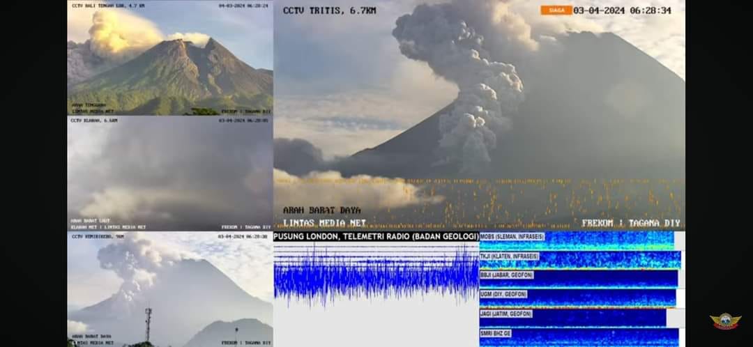
Current status: erupting (4 out of 5)
Central Java, Indonesia, -7.54°S / 110.44°E
Current status: erupting (4 out of 5)
Last update: 10 Apr 2024 (Smithsonian / USGS Weekly Volcanic Activity Report)
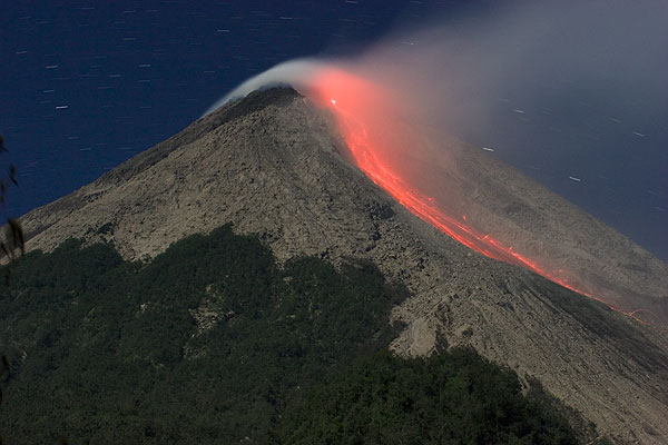
Glowing avalanches of hot rocks from the new lava dome (2006 eruption).
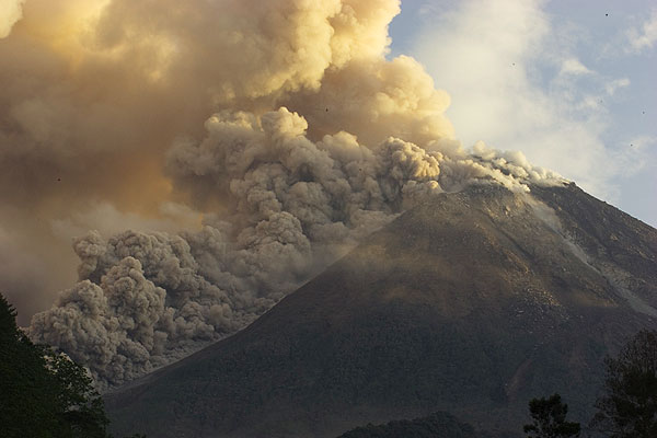
Merapi, a steep stratovolcano north of Central Java's capital Yogyakarta, is Indonesia's most active volcano. It erupts on average every 5-10 years and is feared for its deadly pyroclastic flows - avalanches of hot rocks and gas that are generated when parts of new lava domes constructed during eruptions in the summit crater collapse and slide down the mountain's steep flanks.
The name "Merapi" from old Javanese language means "the one making fire" is a popular name for volcanoes: another volcano with the same name Merapi is in the Ijen Massif in East Java and similarly called volcano "Marapi" lies on Sumatra Island.
[smaller] [larger]
Merapi volcano eruptions: 1548, 1554, 1560, 1584, 1586(?), 1587, 1658, 1663, 1672, 1678, 1745, 1752, 1755, 1768, 1791, 1797, 1807, 1810, 1812-22, 1822-23, 1828, 1832-36, 1837-38, 1840, 1846, 1848(?), 1849, 1854(?), 1861, 1862-64, 1865-71, 1872 (large vulcanian-subplinian eruption VEI:4) , 1872-73, 1878-79, 1883-84, 1885-87, 1888, 1889, 1891-92, 1893, 1894, 1897, 1902, 1902-04, 1905, 1906-07, 1908, 1909-13, 1915, 1918, 1920-21, 1922, 1923(?), 1924, 1930-31, 1932, 1933-35, 1939-40, 1942-45, 1948, 1953-58, 1961, 1967-1970, 1971(?), 1972-85, 1986-90, 1992-2002, April-July 2006, Oct 2010-2011 Feb, 2018 (May), late 2018 - ongoing
Latest nearby earthquakes
| Ώρα | Mag. / Βάθος | Απόσταση / Τοποθεσία | |||
| 8 Απρ 23:49 (Jakarta) | 2.8 14 km | 25 km νοτιοδυτικά | Περ. | ||
Background
Merapi dominates the landscape immediately north of the city of Yogyakarta in one of the world's most densely populated areas. Merapi is the youngest and southernmost of a volcanic chain extending NNW to Ungaran volcano. The steep-sided modern Merapi edifice, its upper part unvegetated due to frequent eruptive activity, was constructed to the SW of an arcuate scarp cutting the eroded older Batulawang volcano. Pyroclastic flows and lahars accompanying growth and collapse of the steep-sided active summit lava dome have devastated cultivated lands on the volcano's western-to-southern flanks and caused many fatalities during historical time. Since 1953, activity has been characterized by extrusion of lava into the summit crater, with periodic lava dome collapse and nuée ardente formation. Summit lava dome growth has continued since the 1969 gas explosion. It is monitored from the Merapi Volcano Observatory (MVO) in Yogyakarta.Merapi Volcano Photos
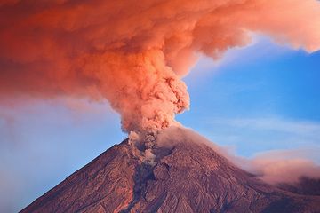
Όρος Μεράπι (Κεντρική Ιάβα, Ινδονησία) σε έκρηξη με τη στήλη τέφρας που φωτίζεται την ανατολή του ηλίου (Νοέμβριος 2010) (Photo: Tom Pfeiffer)...
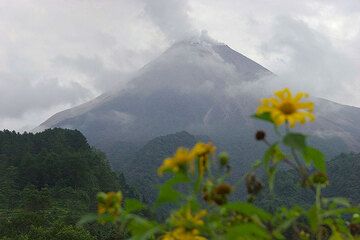
Η Μεράπι φαίνεται από τη ΝΑ πλευρά στις 21 Μαΐου. (Photo: Tom Pfeiffer)

Ηφαίστειο Μεράπι, Κεντρική Ιάβα, Ινδονησία (Photo: Roland Gerth)
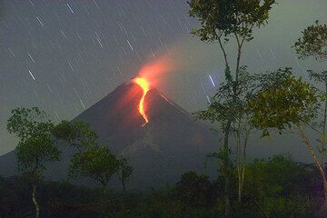
Η έκρηξη του Μεράπι από το Tunggularum (24 Μαΐου 2006). (Photo: Tom Pfeiffer)
Εκρήξεις ηφαιστείου Merapi
April-June 2006 eruption: new lava dome & pyroclastic flows, 2 fatalities
After a period of 5 years of relative calm, a new eruption started in April 2006. A new lava dome was built on top of the lava dome of 1998-2001, powerful pyroclastic flows descended the SW, S and SE flanks in late May and June. Tens of thousands of people were evacuated during the peak of the eruption in late May-mid June. A particularly powerful pyroclastic flow killed two workers trapped inside a shelter that was overrun by a flow on 14 June. ...περισσ. πληροφορίες
After a period of 5 years of relative calm, a new eruption started in April 2006. A new lava dome was built on top of the lava dome of 1998-2001, powerful pyroclastic flows descended the SW, S and SE flanks in late May and June. Tens of thousands of people were evacuated during the peak of the eruption in late May-mid June. A particularly powerful pyroclastic flow killed two workers trapped inside a shelter that was overrun by a flow on 14 June. ...περισσ. πληροφορίες
27 May 2006 Yogyakarta earthquake
On 27 May 2006 a magnitude 6.3 tectonic earthquake near Yogyakarta caused 5750 fatalities, around 40,000 injuries and destroyed large sections of Yogyakarta and sourrounding towns, leaving more than 600,000 people homeless.
The earthquake was caused by the collission of the Australian and Sunda tectonic plates, forming a subduction zone west of the coast of Java.
Jan-Feb 2001 activity: major dome collapse on 10 February
Activity increased in January 2001, lava effusion rates were at high levels and feeding frequent pyroclastic flows. On 31 January pyroclastic flows occurred continuously, reaching up to 3.5 km from the summit, flowing mainly to the SSW, but started also to descend on the SW and W flanks of the mountain into the Senowo and Bebeng Rivers.
On 10 February 2001, a large section of the 1998 lava dome collapsed and triggered a serious of pyroclastic flows that reached 7 km distance from the crater, travelling SSW into the Sat River. Significant ash fall from the eruption occured up to 60 km E of the volcano.
After this event, activity decreased sharply, but continued at lower levels through much of 2001.
Dec 2000- Jan 2001 eruption: pyroclastic flows
Eruptive activity increased steeply during the period of 26 December 2000-22 January 2001. On 14 January, 29 pyroclastic flows traveled down the volcano's SSW and SW flanks and reached up to 4 km from their source. During the week, lava avalanches and pyroclastic flows occurred with an average interval of 0.5-1 hours.
Eruptive activity increased steeply during the period of 26 December 2000-22 January 2001. On 14 January, 29 pyroclastic flows traveled down the volcano's SSW and SW flanks and reached up to 4 km from their source. During the week, lava avalanches and pyroclastic flows occurred with an average interval of 0.5-1 hours.
1998-2000 activity: glowing rockfalls
Seismic activity and rockfalls from the lava dome at the summit increased again in June 1998 and peaked between 11-19 July when 128 rock avalanches and pyroclastic flows were recorded descending the Lamat, Krasak/Bebeng and Boyong rivers on the SW and SSW flanks of the volcano.
Activity decreased, but the volcano remained active through 1999 and 2000, when intense degassing, minor explosions, intermittend glow at the summit and occasional rockfalls were recorded.
1996 eruptions - contining lava dome growth and pyroclastic flows
The activity that had started in 1994 continued through 1995 and increased again starting from August 1996, when explosions and pyroclastic flows became more frequent and large. On 9 August, a pyroclastic flow traveled 3.5 km from the summit down the SSW flank and reached the upper parts of the Krasak and Boyong rivers. No casualties were reported. An explosion on 13 September created an ash cloud of ca. 4 km height above the summit.
Activity peaked on 31 October when 17 pyroclastic flows were recorded. They reached a maximum of 3 km distance and touched the upper valleys of Bebeng, Krasak, Boyong, and Kuning rivers on the SSW and SW flanks.
Pyroclastic flows decreased on 1st November and the eruption ended on 2nd November.
1994 eruption - 41 fatalities
A major collapse of the growing lava dome on November 22 1994 produced a large pyroclastic flow that ran 7.5 km on the S flank, overrunning Kaliurang village and killed at least 41 people. 6000 people were evacuated. ...περισσ. πληροφορίες
A major collapse of the growing lava dome on November 22 1994 produced a large pyroclastic flow that ran 7.5 km on the S flank, overrunning Kaliurang village and killed at least 41 people. 6000 people were evacuated. ...περισσ. πληροφορίες
1992-1993 eruption: new lava dome growth
A new lava dome grew in late January and early February 1992 and generated pyroclastic flows travelling up to 4 km to the SW flank. ...περισσ. πληροφορίες
A new lava dome grew in late January and early February 1992 and generated pyroclastic flows travelling up to 4 km to the SW flank. ...περισσ. πληροφορίες
1968 eruptions
By the end of May 1968 a viscous lava flow had been extruded from the collapse scar of the Oct 1967 dome collapse and reached 875 m SW on the upper slope. Rockfalls and small pyroclastic flows from the lava flow were frequent in June through August (up to ca. 1500 per month) and died out in September. New activity began in October.
By the end of May 1968 a viscous lava flow had been extruded from the collapse scar of the Oct 1967 dome collapse and reached 875 m SW on the upper slope. Rockfalls and small pyroclastic flows from the lava flow were frequent in June through August (up to ca. 1500 per month) and died out in September. New activity began in October.
April-October 1967 eruption
A new lava dome was built in April 1967. Dome collapses in October 1967 generated pyroclastic flows into the Batang river valley on the SW side of the cone.
A new lava dome was built in April 1967. Dome collapses in October 1967 generated pyroclastic flows into the Batang river valley on the SW side of the cone.
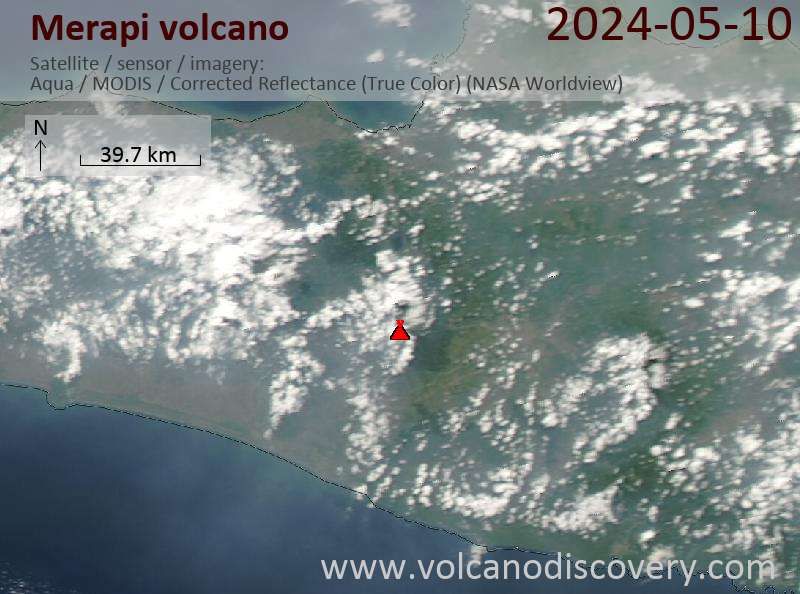
Latest satellite images
Merapi Volcano Tours
Java (Indonesia)
From Krakatau to Bali
16-ημερών εργαστήριο Φωτοδιαδρομή να τα ηφαίστεια πάνω στην Ιάβα, Ινδονησία
16 days - Easy to Moderate
Price 3180 €
Price 3180 €
Custom and group dates
2-17 Aug 2024
2-17 Jun 2024
8-23 Jul 2024
Java (Indonesia)
Volcanoes of Java
17-day walking and trekking tour on Java
17 days / 16 nights - Moderate to Challenging
Price 3120 €
Price 3120 €
3-19 Jun 2024
9-25 Jul 2024
3-19 Aug 2024
Flores, Indonesia
Indonesia Volcano Special
Volcano expedition to Lewotobi and Ile Lewotolok volcanoes in Feb 2024
7 days (10 days with extension) - Moderate
Price 1750 EUR (7d) / 2480 EUR (10d)
Price 1750 EUR (7d) / 2480 EUR (10d)
no scheduled dates at present