Contact | RSS | EN | DE | EL | ES | FR | IT | RU

Emi Koussi Volcano

Updated: Apr 19, 2024 07:41 GMT -
Pyroclastic shield 3415 m / 11,204 ft
Chad, 19.8°N / 18.53°E
Current status: normal or dormant (1 out of 5)

[smaller] [larger]
Typical eruption style: unspecified
Emi Koussi volcano eruptions: unknown, no recent eruptions

Latest nearby earthquakes

No recent earthquakes
TimeMag. / DepthDistance / Location

Background

The large volcano of Emi Koussi at the SE end of the Tibesti Range forms the highest summit of the Sahara. The 60 x 80 km massif was constructed over a basement of Cretaceous and Paleozoic sandstones. Two nested calderas, 12 x 15 km in size, truncate the dominantly trachytic volcano, whose 3415 m high point lies on the southern caldera rim of the low-angle pyroclastic shield volcano. The calderas contain several explosion craters, lava domes, and young scoria cones, along with lava flows of recent and pre-modern age (Geze et al., 1959). The spectacular Era Kohor (Trou au Natron du Koussi) caldera on the SE floor of the 2nd caldera is 2-3 km wide and 350 m deep. The latest activity in the calderas produced three maars, and numerous basaltic cinder cones and associated lava flows have been constructed both within the calderas and on their outer flanks. The Yi-Yerra thermal area is located on the southern flank.
---
Smithsonian / GVP volcano information

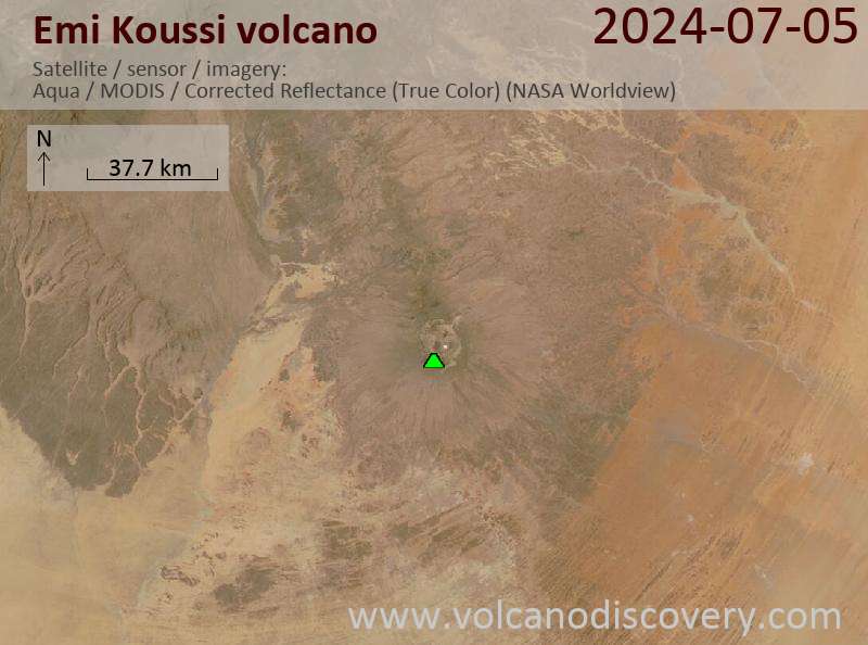
Latest satellite images

emikoussi satellite image sat1emikoussi satellite image sat2

No news in this list.

On this page:

Try our free app!
Volcanoes & Earthquakes - new app for Android
Android | iOS version

More on VolcanoDiscovery

Why is there advertising on this site?

Support us - Help us upgrade our services!

We truly love working to bring you the latest volcano and earthquake data from around the world. Maintaining our website and our free apps does require, however, considerable time and resources.
We need financing to increase hard- and software capacity as well as support our editor team. We're aiming to achieve uninterrupted service wherever an earthquake or volcano eruption unfolds, and your donations can make it happen! Every donation will be highly appreciated. If you find the information useful and would like to support our team in integrating further features, write great content, and in upgrading our soft- and hardware, please make a donation (PayPal or Online credit card payment).

Planned features:Thanks to your past donations, these features have been added recently:
Download and Upgrade the Volcanoes & Earthquakes app to get one of the fastest seismic and volcano alerts online:
Android | IOS
Thank you!
Sources: VolcanoDiscovery / VolcanoAdventures and other sources as noted.
Use of material: Most text and images on our websites are owned by us. Re-use is generally not permitted without authorization. Contact us for licensing rights.
Volcanoes & Earthquakes
VolcanoDiscovery Home
Volcanoes | Earthquakes | Photos | Volcano News | App
Adventure & Study Travel
Tours to Volcanoes and Volcanic Areas: walking tours, photo tours, study tours
Tours & Dates | FAQ | About us
Get our newsletter!
Company info
Contact | Legal info | Terms & conditions
Follow us
Follow us on facebook Follow us on Instagram Follow us on Twitter Visit our Youtube channel
EN | DE | EL | ES | FR | IT | RU
VolcanoDiscovery GmbH, Germany, Reg. nr.: HRB 103744, EU Tax Id: DE 297 465 123 owned and created by
Dr. Tom Pfeiffer, volcanologist, volcano photographer, tour organizer member of
IAVCEI
IAVCEI
Vulkanologische Gesellschaft
Volcanological Society
Ecotourism Greece
Ecotourism Greece
RUV insurance
Insured by R+V
VolcanoDiscovery © 2004- All Rights Reserved | Privacy - Cookie Settings