Contacto | RSS | EN | DE | EL | ES | FR | IT | RU

Daisetsu Volcano

Updated: 19 abr. 2024 00:54 GMT -
stratovolcano 2290 m / 7,513 ft
Hokkaidō (Japón), 43.66°N / 142.86°E
Current status: normal or dormant (1 out of 5)

Daisetsu (also spelled Taisetsu or Taisetsuzan) volcano is a group of 8 stratovolcanoes, lava domes and a small 2 km wide caldera in the Daisetsu-zan National Park (the roof of Hokkaido) in central Hokkaido.
Asahi (旭岳 Asahi-dake) volcano is the highest peak of the volcanic complex and the highest mountain in Hokkaido.
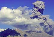
No historical eruptions are known from Daisetsu, although the last eruption must have taken place in or after 1739 AD. At present, there are fumaroles and sulfur was mined at Asahi-dake.
Daisetsu-zan National Park is the largest national park of Japan covering 230,000 ha. The park stretches from Mt. Torashiumu to the Tokachi Mountains. It is known for its hot springs, which can be found at Sounkyou, Yukomanbetsu, Tenninkyou, Nukabira, Shirogane, Shikaribetsu and Tomuraushi.

[smaller] [larger]
Typical eruption style: explosive
Erupciones del volcán Daisetsu: >=1739 AD (tephrachronology), 550 BC ± 500 years, 1450 BC ± 50 years, 2800 BC ± 100 years, 3200 BC ± 75 years (radiocarbon dated)

Latest nearby earthquakes

No hay terremotos recientes
Fecha / HoraRevista / Prof.Distancia / Ubicación

Background

The Daisetsu volcanic group formed at the northern end of the Daisetsu-Tokachi tectonic graben. Several vents are aligned along a ring fracture over the eastern rim of the caldera and on a NE-SW line cutting through the caldera and trending towards the Tokachi volcano complex to the SW. (Smithsonian / GVP volcano information)

Latest satellite images

Daisetsu satellite image sat1Daisetsu satellite image sat2

No news in this list.

En esta página:

Try our free app!
Volcanoes & Earthquakes - new app for Android
Android | iOS version

Más en VolcanoDiscovery

Why is there advertising on this site?

Support us - Help us upgrade our services!

We truly love working to bring you the latest volcano and earthquake data from around the world. Maintaining our website and our free apps does require, however, considerable time and resources.
We need financing to increase hard- and software capacity as well as support our editor team. We're aiming to achieve uninterrupted service wherever an earthquake or volcano eruption unfolds, and your donations can make it happen! Every donation will be highly appreciated. If you find the information useful and would like to support our team in integrating further features, write great content, and in upgrading our soft- and hardware, please make a donation (PayPal or Online credit card payment).

Planned features:Thanks to your past donations, these features have been added recently:
Download and Upgrade the Volcanoes & Earthquakes app to get one of the fastest seismic and volcano alerts online:
Android | IOS
Thank you!
Sources: VolcanoDiscovery / VolcanoAdventures and other sources as noted.
Use of material: Most text and images on our websites are owned by us. Re-use is generally not permitted without authorization. Contact us for licensing rights.
Volcanoes & Earthquakes
VolcanoDiscovery Home
Volcanes | Sismos | Fotos | News | App
Adventure & Study Travel
Tours to Volcanoes and Volcanic Areas: walking tours, photo tours, study tours
Tours & Dates | FAQ | About us
Get our newsletter!
Company info
Contact | Legal info | Terms & conditions
Follow us
Follow us on facebook Follow us on Instagram Follow us on Twitter Visit our Youtube channel
EN | DE | EL | ES | FR | IT | RU
VolcanoDiscovery GmbH, Germany, Reg. nr.: HRB 103744, EU Tax Id: DE 297 465 123 owned and created by
Dr. Tom Pfeiffer, volcanologist, volcano photographer, tour organizer member of
IAVCEI
IAVCEI
Vulkanologische Gesellschaft
Volcanological Society
Ecotourism Greece
Ecotourism Greece
RUV insurance
Insured by R+V
VolcanoDiscovery © 2004- All Rights Reserved | Privacy - Cookie Settings