Contacto | RSS | EN | DE | EL | ES | FR | IT | RU

Fernandina Volcano

Updated: 18 abr. 2024 03:08 GMT -
Shield volcano 1476 m / 4,842 ft
Galápagos Islands, Ecuador, -0.37°S / -91.55°W
Current status: erupting (4 out of 5)
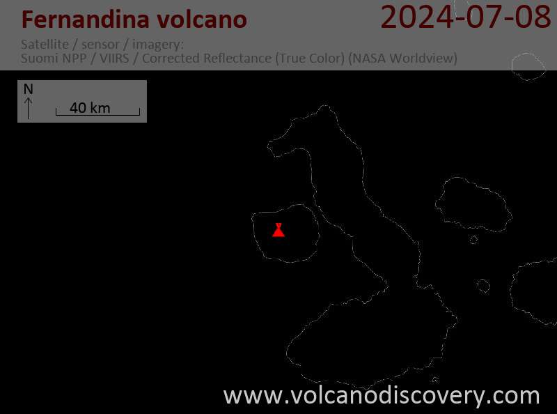
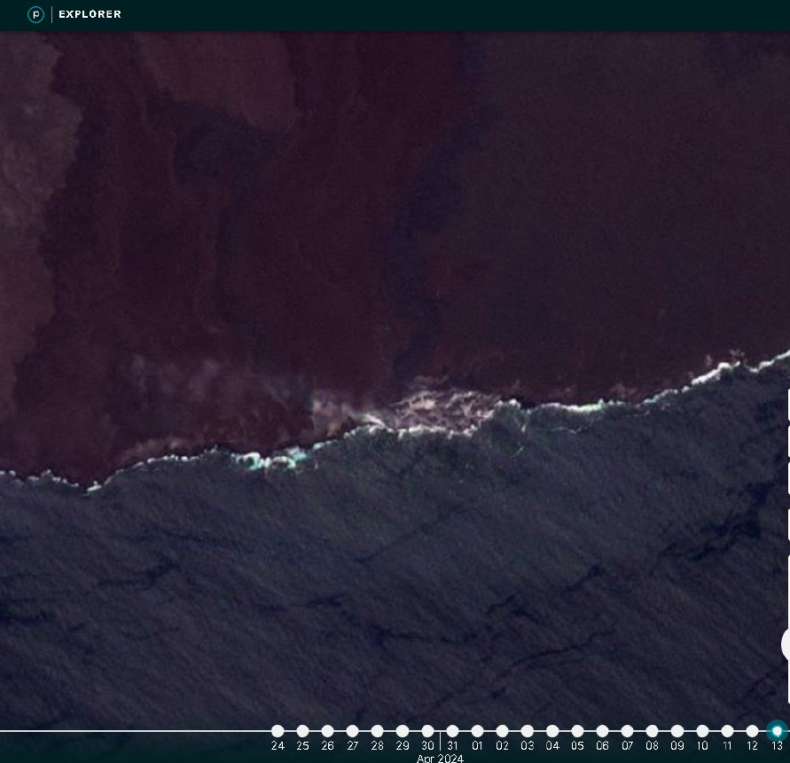
Last update: 15 abr 2024 (progression lava flow has diminished)
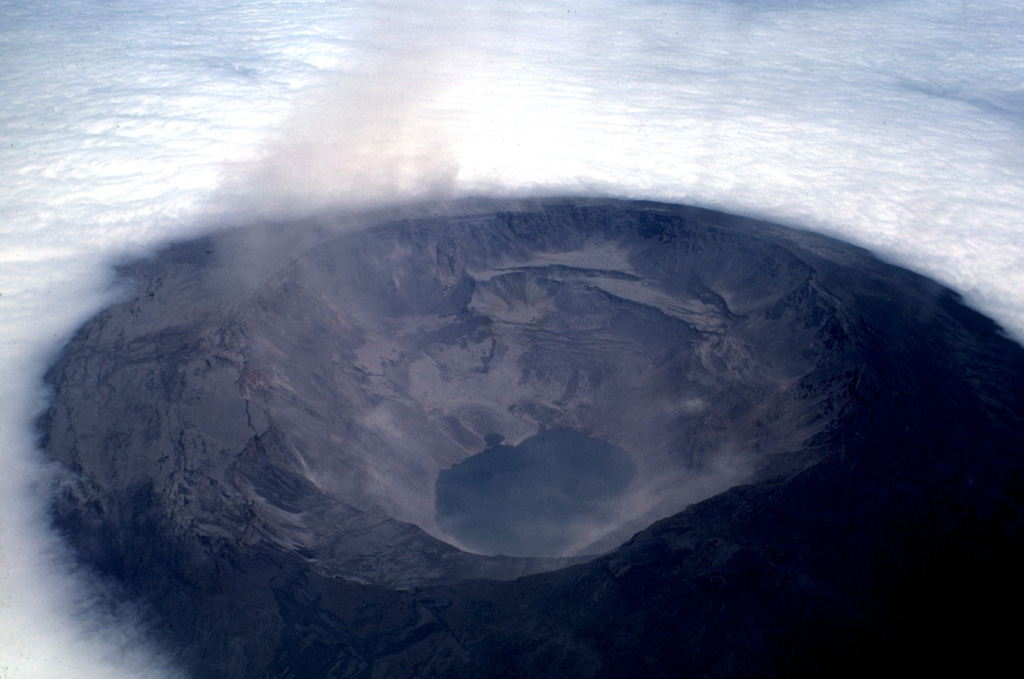
The Fernandina caldera seen on July 4, 1968, about three weeks after a major explosive eruption that was followed by collapse of the caldera floor. Collapse occurred incrementally and asymmetrically, ranging up to about 350 m at the SE end of the caldera, which contains the caldera lake. Photo by Tom Simkin, 1968 (Smithsonian Institution).

[smaller] [larger]
Typical eruption style: Effusive, basaltic fissure eruptions
Erupciones del volcán Fernandina: 2020, 2018, 2017, 2009

Latest nearby earthquakes

No hay terremotos recientes
Fecha / HoraRevista / Prof.Distancia / Ubicación

Background

Fernandina, the most active of Galápagos volcanoes and the one closest to the Galápagos mantle plume, is a basaltic shield volcano with a deep 5 x 6.5 km summit caldera. The volcano displays the classic "overturned soup bowl" profile of Galápagos shield volcanoes. Its caldera is elongated in a NW-SE direction and formed during several episodes of collapse. Circumferential fissures surround the caldera and were instrumental in growth of the volcano.
Reporting has been poor in this uninhabited western end of the archipelago, and even a 1981 eruption was not witnessed at the time. In 1968 the caldera floor dropped 350 m following a major explosive eruption. Subsequent eruptions, mostly from vents located on or near the caldera boundary faults, have produced lava flows inside the caldera as well as those in 1995 that reached the coast from a SW-flank vent. Collapse of a nearly 1 cu km section of the east caldera wall during an eruption in 1988 produced a debris-avalanche deposit that covered much of the caldera floor and absorbed the caldera lake.
---
Source: Smithsonian / GVP volcano information

Latest satellite images

fernandina satellite image sat1fernandina satellite image sat2
lun, 15 abr 2024, 03:01

Fernandina volcano (Galápagos Islands): progression lava flow has diminished

Minor amount of water vapor and gas emissions emitting from the lava delta on 13 April (image: PlanetScope)
The effusive eruption at the volcano continues. ... Read all
mié, 10 abr 2024, 14:00

Fernandina volcano (Isla Fernandina, Galapagos) - Smithsonian / USGS Weekly Volcanic Activity Report for 3 April-9 April 2024 (New Activity / Unrest)

Instituto Geofísico-Escuela Politécnica Nacional (IG-EPN) reported that during 2 March-1 April an estimated 44 million cubic meters of lava had erupted at Fernandina, making the current eruption the largest in the last 15 years, surpassed only by the 2009 eruption. Fissure 13, located just below the crater rim on the upper SE flank, continued to be active during 2-9 April; the rate of lava effusion was about five cubic meters per second at least through 4 April, though the advancement rate of the distal end of the lava flow was variable. Sulfur dioxide emissions were generally at moderate levels, fluctuating between about 100 and 1,000 tons per day, though emissions were as high as around 1,650 tons per day on 4 April. ... Read all

En esta página:

Try our free app!
Volcanoes & Earthquakes - new app for Android
Android | iOS version

Más en VolcanoDiscovery

Why is there advertising on this site?

Support us - Help us upgrade our services!

We truly love working to bring you the latest volcano and earthquake data from around the world. Maintaining our website and our free apps does require, however, considerable time and resources.
We need financing to increase hard- and software capacity as well as support our editor team. We're aiming to achieve uninterrupted service wherever an earthquake or volcano eruption unfolds, and your donations can make it happen! Every donation will be highly appreciated. If you find the information useful and would like to support our team in integrating further features, write great content, and in upgrading our soft- and hardware, please make a donation (PayPal or Online credit card payment).

Planned features:Thanks to your past donations, these features have been added recently:
Download and Upgrade the Volcanoes & Earthquakes app to get one of the fastest seismic and volcano alerts online:
Android | IOS
Thank you!
Sources: VolcanoDiscovery / VolcanoAdventures and other sources as noted.
Use of material: Most text and images on our websites are owned by us. Re-use is generally not permitted without authorization. Contact us for licensing rights.
Volcanoes & Earthquakes
VolcanoDiscovery Home
Volcanes | Sismos | Fotos | News | App
Adventure & Study Travel
Tours to Volcanoes and Volcanic Areas: walking tours, photo tours, study tours
Tours & Dates | FAQ | About us
Get our newsletter!
Company info
Contact | Legal info | Terms & conditions
Follow us
Follow us on facebook Follow us on Instagram Follow us on Twitter Visit our Youtube channel
EN | DE | EL | ES | FR | IT | RU
VolcanoDiscovery GmbH, Germany, Reg. nr.: HRB 103744, EU Tax Id: DE 297 465 123 owned and created by
Dr. Tom Pfeiffer, volcanologist, volcano photographer, tour organizer member of
IAVCEI
IAVCEI
Vulkanologische Gesellschaft
Volcanological Society
Ecotourism Greece
Ecotourism Greece
RUV insurance
Insured by R+V
VolcanoDiscovery © 2004- All Rights Reserved | Privacy - Cookie Settings