Contacto | RSS | EN | DE | EL | ES | FR | IT | RU

Garibaldi Volcano

Updated: 19 abr. 2024 19:27 GMT -
stratovolcano 2678 m / 8,786 ft
Canadá, 49.85°N / -123°W
Current status: normal or dormant (1 out of 5)
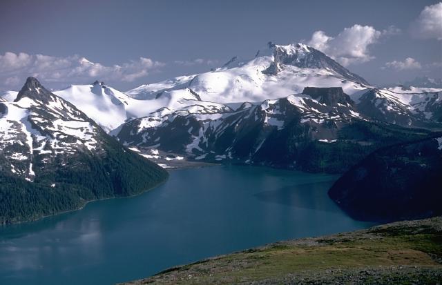
Mount Garibaldi, rising above scenic Garibaldi Lake to the north, is a largely Pleistocene stratovolcano capped by a lava dome complex. The volcano was partially constructed over the Cordilleran ice sheet and displays many ice-contact features. Its final eruptions during the early Holocene included the emission of lava flows that mantled the west-side landside headwall and a massive lava flow from Opal Cone, a SE flank vent, that traveled 20 km to the south and west. Photo by Lee Siebert, 1983 (Smithsonian Institution)

Mt Garibaldi volcano at the head of Howe Sound, 66 km north of Vancouver in SW British Columbia is probably Canada's best-known volcano and part of the active Cascades Range. It is a young stratovolcano capped by a complex of lava domes. Its most recent eruptions occurred at the Opal Cone on the SE flank ca. 8000 years ago and produced the Ring Creek lava flow.

[smaller] [larger]
Typical eruption style: explosive
Erupciones del volcán Garibaldi: 8060 BC ± 500 (radiocarbon dated)

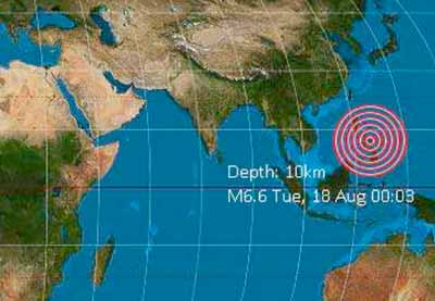
Latest nearby earthquakes

Fecha / HoraRevista / Prof.Distancia / Ubicación
6 abr 19:56 (Vancouver)
0.6

6 km
20 km al sur 4.9 km al sureste de Squamish, Squamish-Lillooetal, Columbia Británica, Canadá
Más

Background

Mount Garibaldi's oldest known products are around half a million years old. Its first period of activity ended about 220,000 years ago and was followed by a period of quiescence. After this interval, a conical plug dome and breccia pile was formed at the south summit, Atwell Peak. Retreat of the ice cap at the end of the ice age left the west flank unsupported, and it collapsed in a series of landslides, exposing the core of the volcano. Lava flows from Dalton Dome north of Atwell Peak flowed down the scarp. Subglacial flank centers such as Eanastick (Enostuck) Meadow, Glacier Pike and Paul Ridge were also formed during the late Pleistocene.
The final activity of Mount Garibaldi formed the Opal Cone on the SE flank and the lengthy Ring Creek lava flow, which filled a glaciated valley on the south flank during the early Holocene.
---
Source: GVP volcano information

Garibaldi Volcano Photos
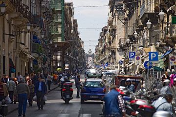
Latest satellite images

Garibaldi satellite image sat1Garibaldi satellite image sat2

No news in this list.

En esta página:

Try our free app!
Volcanoes & Earthquakes - new app for Android
Android | iOS version

Más en VolcanoDiscovery

Why is there advertising on this site?

Support us - Help us upgrade our services!

We truly love working to bring you the latest volcano and earthquake data from around the world. Maintaining our website and our free apps does require, however, considerable time and resources.
We need financing to increase hard- and software capacity as well as support our editor team. We're aiming to achieve uninterrupted service wherever an earthquake or volcano eruption unfolds, and your donations can make it happen! Every donation will be highly appreciated. If you find the information useful and would like to support our team in integrating further features, write great content, and in upgrading our soft- and hardware, please make a donation (PayPal or Online credit card payment).

Planned features:Thanks to your past donations, these features have been added recently:
Download and Upgrade the Volcanoes & Earthquakes app to get one of the fastest seismic and volcano alerts online:
Android | IOS
Thank you!
Sources: VolcanoDiscovery / VolcanoAdventures and other sources as noted.
Use of material: Most text and images on our websites are owned by us. Re-use is generally not permitted without authorization. Contact us for licensing rights.
Volcanoes & Earthquakes
VolcanoDiscovery Home
Volcanes | Sismos | Fotos | News | App
Adventure & Study Travel
Tours to Volcanoes and Volcanic Areas: walking tours, photo tours, study tours
Tours & Dates | FAQ | About us
Get our newsletter!
Company info
Contact | Legal info | Terms & conditions
Follow us
Follow us on facebook Follow us on Instagram Follow us on Twitter Visit our Youtube channel
EN | DE | EL | ES | FR | IT | RU
VolcanoDiscovery GmbH, Germany, Reg. nr.: HRB 103744, EU Tax Id: DE 297 465 123 owned and created by
Dr. Tom Pfeiffer, volcanologist, volcano photographer, tour organizer member of
IAVCEI
IAVCEI
Vulkanologische Gesellschaft
Volcanological Society
Ecotourism Greece
Ecotourism Greece
RUV insurance
Insured by R+V
VolcanoDiscovery © 2004- All Rights Reserved | Privacy - Cookie Settings