Geureudong Volcano
Updated: 20 abr. 2024 06:28 GMT -
Stratovolcano 2885 m (9,465 ft)
Sumatra (Indonesia), 4.77°N / 96.82°E
Current status: normal or dormant (1 out of 5)
Sumatra (Indonesia), 4.77°N / 96.82°E
Current status: normal or dormant (1 out of 5)
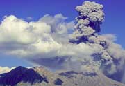
The massive Bur ni Geureudong volcanic complex, one of the largest in northern Sumatra, consists of the two adjacent volcanoes of Bur ni Geureudong and Bur ni Telong.
[smaller] [larger]
Erupciones del volcán Geureudong: 1837, 1839, 1856, 1919, 1924(?), 1937
Latest nearby earthquakes
| Fecha / Hora | Revista / Prof. | Distancia / Ubicación | |||
Background
The former is eroded and Pleistocene in age, but has solfataras and hot springs on its flanks. The historically active Bur ni Telong volcano was constructed on the southern flank of Bur ni Geureudong, 4.5 km from its summit, and grew to a height of 2624 m, 34 m above that of Geureudong. The summit crater of Bur ni Telong has migrated to the ESE, leaving arcuate crater rims. Lava flows are exposed on the southern flank. Explosive eruptions were recorded during the 19th and 20th centuriesSource: Smithsonian, GVP.
Latest satellite images