Contacto | RSS | EN | DE | EL | ES | FR | IT | RU
[menor] [más grande]

Bali (6 volcanoes)

Agung | Batur | Bratan | Merbuk | Patas | Seraja

Mar de banda (9 volcanoes)

Banda Api | Emperor of China | Gunung Api Wetar | Manuk | Nieuwerkerk | Nila | Serua | Teon | Wurlali

Java Central (12 volcanoes)

Dieng | Lasem | Lawu | Merapi | Merbabu | Muria | Slamet | Sumbing | Sundoro | Telomoyo | Ungaran | Wilis

Java Oriental (16 volcanoes)

Argowayang | Arjuno-Welirang | Baluran | Bromo | Ijen | Iyang-Argapura | Kawi-Butak | Kelud | Lamongan | Lurus | Malang Plain | Penanggungan | Raung | Ringgit | Selokaki | Semeru

Flores (16 volcanoes)

Ebulobo | Egon | Gunung Beliling | Ilikedeka | Ilimuda | Inielika | Inierie | Iya | Kelimutu | Leroboleng | Lewotobi | Ndete Napu | Poco Leok | Ranakah | Sukaria | Wai Sano

Halmahera (16 volcanoes)

Amasing | Bibinoi | Dukono | Gamalama | Gamkonora | Hiri | Ibu | Jailolo | Makian | Mare | Moti | Tarakan | Tidore | Tigalalu | Tobaru | Todoko-Ranu

Islas menores de la Sonda (11 volcanoes)

Batu Tara | Doro Ora | Doro Otota | Gilbanta | Iliboleng | Ililabalekan | Iliwerung | Lewotolo | Paluweh | Sangeang Api | Sirung

Lombok (2 volcanoes)

Punikan | Rinjani

Islas Sulawesi y Sangihe (21 volcanoes)

Ambang | Awu | Banua Wuhu | Hamiding | Karangetang | Kawalusu | Kawio Barat | Klabat | Lipang | Lokon-Empung | Lompobatang | Mahawu | Napo Taroare | North Kawio | Ruang | Sempu | Soputan | Tangkoko | Tondano | Una Una | Unnamed

Sumatra (68 volcanoes)

Barus | Bekulap | Belirang-Beriti | Besar | Bukit Daun | Bukit Lumut | Bukit Lumut Balai | Bukit Nanti | Bukit Telor | Bukit Tenaroh | Bukit Tiga | Dempo | Geureudong | Geureugoh | Gunung Sembuang | Gunung Telago | Gunung Tudeuk | Helatoba-Tarutung | Hulubelu | Hulunilo | Hutapanjang | Imun | Isau-Isau | Kaba | Kembar | Kerinci | Lubukraya | Maninjau | Marapi | Martimbang | Masurai | Melintang | Nama Salah | Olim | Patah | Pendan | Pesagi | Pesawaran-Ratai | Peuet Sague | Pulau Weh | Raja | Raja-Sabanda | Rajabasa | Ranau caldera | Runcing | Sarik-Gajah | Sekincau Belirang | Seulawah Agam | Seulawah Inong | Sibayak | Sibualbuali | Simbolon | Sinabung | Sorikmarapi | Sukadana Basalts | Sumbing | Suoh | Takur-Takur | Talakmau | Talang | Tandikat | Tanggamus | Telong | Teu Minas | Toba | Tujuh | Tungkat | Uruk Simacak

Sumbawa (7 volcanoes)

Doro Lambuwu | Doro Maria | Doro Saboke | Ramu-Labumbu | Sangenges | Tambora | Tarowa

Estrecho de sonda (1 volcano)

Krakatau

Java Occidental (35 volcanoes)

Cakrabuana | Canlancang | Cibugis | Cikuray | Ciremai | Danau | Endut | Gagak | Galunggung | Gede | Gede-Pangrango | Guntur | Gunung Putri | Halimun | Halimun (2) | Kancana | Kancana (2) | Karang | Kawah Kamojang | Kawah Karaha | Kendang | Kendeng | Mandalagiri | Mandalawangi-Haruman | Papandayan | Perbakti | Pulosari | Salak | Sanggabuana | Sawal | Sedakeling | Talagabodas | Tampomas | Tangkubanparahu | Tilu

Volcanoes of Indonesia (147 volcanoes)

Actualizado: 18 abr. 2024 01:57 GMT -
Each volcano in Indonesia is listed that has erupted within the past 10,000 years as well as many older ones active in the Pleistocene. Please navigate on the map or the volcano list below to get more information about an individual volcano.

Introduction

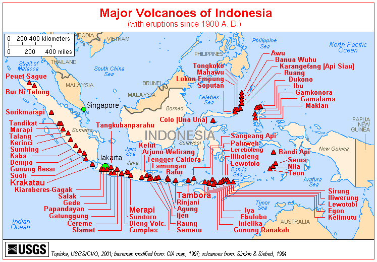
The archipelago of Indonesia consists of more than 13,000 islands, spread over an area that is similar in size to that of the continental United States. It is the country with the greatest number and density of active volcanoes.


Most volcanoes in Indonesia belong to the Sunda Volcanic Arc, streching over 3,000 kilometers from NW Sumatra to the Banda Sea. This volcanic arc results from the subduction of Indian Ocean crust beneath the Asian Plate and includes 76% of the region's volcanoes. To the NNW, the basaltic volcanism of the Andaman Islands results from short spreading centers, and to the east the Banda Arc reflects Pacific Ocean crust subducted westward. North of this arc, the tectonic setting is much more complex: several fragments of plates are converging  to form multiple subduction zones, mainly oriented N-S. These produce the Sulawesi-Sangihe volcanoes on the west and Haimahera on the east of the collision zone.


Indonesia leads the world in many volcano statistics. It has the largest number of historically active volcanoes (76), its total of 1,171 dated eruptions is only narrowly exceeded by Japan's 1,274, although not much is know about the volcanic activity in the time before European colonialists arrived from the 15th century on. Indonesia has suffered the highest numbers of eruptions producing fatalities, damage to arable land, mudflows, tsunamis, domes, and pyroclastic flows. Four-fifths of Indonesian volcanoes with dated eruptions have erupted in this century.


Two of the most devastating volcanic eruptinos in historic time took place in Indonesia: the enormous eruption of Tambora in 1815,- the largest known eruption of the world during historical times,- had such far-reaching effects on the climate that for instance Europe was to experience 1816 as the year without summer. In 1883, the disastrous eruption of Krakatau carved itself deeply into the collective memory of mankind. The eruption of Krakatau was followed by severe tsunamis that killed about 30-40,000 people.


In 1920, a volcano survey was established by the Dutch-led government, leading to much improved volcano monitoring and reporting. The Volcanological Survey of Indonesia (VSI) now operates a network of 64 volcano observatories continuously monitoring 59 volcanoes.


---
Freely adapted from: Simkin and Siebert, 1994, Volcanoes of the World: Smithsonian Institution and Geoscience Press, Inc., Tucson, Arizona, 349p.


Try our free app!
Volcanoes & Earthquakes - new app for Android
Android | iOS version

Más en VolcanoDiscovery

Why is there advertising on this site?

Support us - Help us upgrade our services!

We truly love working to bring you the latest volcano and earthquake data from around the world. Maintaining our website and our free apps does require, however, considerable time and resources.
We need financing to increase hard- and software capacity as well as support our editor team. We're aiming to achieve uninterrupted service wherever an earthquake or volcano eruption unfolds, and your donations can make it happen! Every donation will be highly appreciated. If you find the information useful and would like to support our team in integrating further features, write great content, and in upgrading our soft- and hardware, please make a donation (PayPal or Online credit card payment).

Planned features:Thanks to your past donations, these features have been added recently:
Download and Upgrade the Volcanoes & Earthquakes app to get one of the fastest seismic and volcano alerts online:
Android | IOS
Thank you!
Sources: VolcanoDiscovery / VolcanoAdventures and other sources as noted.
Use of material: Most text and images on our websites are owned by us. Re-use is generally not permitted without authorization. Contact us for licensing rights.
Volcanoes & Earthquakes
VolcanoDiscovery Home
Volcanes | Sismos | Fotos | News | App
Adventure & Study Travel
Tours to Volcanoes and Volcanic Areas: walking tours, photo tours, study tours
Tours & Dates | FAQ | About us
Get our newsletter!
Company info
Contact | Legal info | Terms & conditions
Follow us
Follow us on facebook Follow us on Instagram Follow us on Twitter Visit our Youtube channel
EN | DE | EL | ES | FR | IT | RU
VolcanoDiscovery GmbH, Germany, Reg. nr.: HRB 103744, EU Tax Id: DE 297 465 123 owned and created by
Dr. Tom Pfeiffer, volcanologist, volcano photographer, tour organizer member of
IAVCEI
IAVCEI
Vulkanologische Gesellschaft
Volcanological Society
Ecotourism Greece
Ecotourism Greece
RUV insurance
Insured by R+V
VolcanoDiscovery © 2004- All Rights Reserved | Privacy - Cookie Settings