Contact | RSS | EN | DE | EL | ES | FR | IT | RU

Myojinsho Volcano

Updated: 23 abr. 2024 21:41 GMT -
submarine volcano 11 m / 36 ft
Islas Izu (Japón), 31.88°N / 139.92°E
Current status: normal or dormant (1 out of 5)
Last update: 1 feb 2023 (Smithsonian / USGS Weekly Volcanic Activity Report)
Steam pours from the blocky summit of a lava dome formed at Myojin-sho during a submarine eruption at the Bayonnaise Rocks volcano in 1952. This September 22 photo was taken 6 days after the dome began to breach the sea surface. Later that day the eruption became highly explosive, and the dome was destroyed. Three cycles of dome growth and destruction occurred until October 1953. Myojin-sho is located on the eastern rim of a 7-9 km wide submarine caldera. (Photo: Helen Foster / USGS)

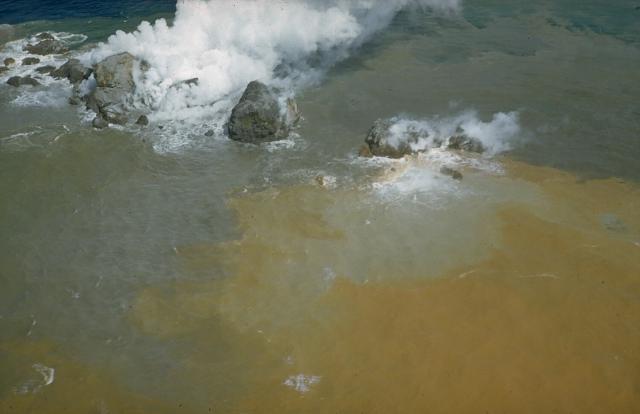
Myojinsho is a large submarine caldera volcano in the Izu Islands arc, ca. 400 km south of Tokyo. Its most well-known feature are the Bayonnaise Rocks (ベヨネース列岩 Beyonēsu-retsugan), which represent a small exposed rim of the caldera composed of a few rocks rising just above sea level.
Myojinsho caldera is 8-9 km wide and has been known for its submarine eruptions which sometimes produce temporary islands. Most of its frequent eruptions have occurred at Myojin-sho, a large young lava dome on the NE rim of the caldera. In 1952, an explosive eruption at Myojin-sho destroyed a Japanese research vessel, killing all 31 people on board.
There is only sparse vegetation on the Bayonnaise Rocks, but the islands are an important resting place for migratory birds. Located in the Kuroshio Current, the waters around have abundant sea life and are popular with sports fishermen.

[smaller] [larger]
Typical eruption style: effusive (lava dome)
Erupciones del volcán Myojinsho: 1988(?), 1987(?), 1986(?), 1983(?), 1980(?), 1979(?), 1971(?), 1970, 1960, 1959, 1958, 1957, 1955, 1954, 1952-53, 1946, 1934, 1915, 1906, 1896

Latest nearby earthquakes

No hay terremotos recientes
Fecha / HoraRevista / Prof.Distancia / Ubicación

Background

The formation of the Bayonnaise Rocks caldera was followed by construction of a large (2.6 km3) lava dome and/or lava complex of lava flows on the caldera floor, which was originally at a depth of 1000-1100 m.
Bayonnaise Rocks has deposits from submarine pyroclastic flows which are the result of the growth of the dacitic lava dome. These deposits mantle the conical dome and extend into the NE part of the caldera and down its outer slopes.
(Source: Smithsonian / GVP volcano information)

Erupciones del volcán Myojinsho


1952-53 eruption and Kaiyo-maru no. 5 disaster
The eruption of Myozin-sho in 1951-54 (Bayonnaise rocks volcano) was one the most notable eruption in Japan during the 1950s.
The first report of a new submarine eruption was on 17 September 1952 by a crew of the fishing boat Myozin-maru No. 11. The site of the eruption was the Myozin-sho lava dome at the NE end of Bayonnaise Rocks. The activity quickly formed a temporary island 150 m long, 100 m wide and 30 m high. The island was eroded and disappeared again by 23 September. An explosive eruption produced a 2 m high tsumani on 24 September.

The Kaiyo-maru No. 5 disaster:
Kaiyo-maru No. 5 was a Japanese research vessel for marine observation from the Hydrographic Office of the Maritime Safety Board in Japan. The ship sailed from Tokyo on 23 September 1952 to survey the submarine topography in the vicinity of the eruption.
The exact circumstances being unknown, the ship must have capsized and sunk quickly when it was at close range of a submarine explosive eruption 12h30 local time on 24 September 1952. All men on board (31) including 9 scientists were lost and there were no eye-witnesses to the tragedy. A tide gauge at Hatizyo-sima Weather Station, 120 km north Myozin-syo, recorded a 2 m high passing tsunami at 12h53 m, ca 25 minutes after the explosion of the volcano. US Navy hydrophones on Hawaii measured underwater sounds from the explosions.
Later, wreckage of the Kaiyo-maru No. 5 was found drifting south of the volcano during 25-28 September. Pieces of fragmental lava and pumice from Myozin-sho volcano were found attached to to some parts of the wreckage, suggesting that the vessel was directly hit by powerful jets of water and tephra ejected during the explosion.

Source:
Takeshi Minakami (1956) "Report on volcanic activities and volcanological studies in Japan for the period from 1951 to 1954", Bull. Volc., Volume 18 (1), pp. 39-76


1906 eruption
A submarine eruption from Bayonnaise Rocks occurred between 7-13 April 1906. Large amounts of pumice were found floating on the sea.

Latest satellite images

Myojinsho satellite image sat1Myojinsho satellite image sat2
mié, 1 feb 2023, 15:00

Myojinsho volcano (Izu Islands) - Smithsonian / USGS Weekly Volcanic Activity Report for 25 January-31 January 2023 (New Activity / Unrest)

According to JMA an area of pale yellow-green discolored water with a diameter of about 100 m was visible about 65 km SSE of Myojinsho on 26 January, based on an overflight conducted by the Japan Coast Guard. An eruption warning was issued to mariners. Discolored water was last observed in March 2017. ... Read all
mié, 21 mar 2018, 06:00

Myojinsho volcano (Japan) - Smithsonian / USGS Weekly Volcanic Activity Report for 21 March-27 March 2018 (New Activity / Unrest)

JMA issued a warning on 24 March for the waters surrounding Myojinsho after reports from the Japan Coast Guard indicated discolored water from a possible eruptive event. ... Read all

En esta página:

Try our free app!
Volcanoes & Earthquakes - new app for Android
Android | iOS version

Más en VolcanoDiscovery

Why is there advertising on this site?

Support us - Help us upgrade our services!

We truly love working to bring you the latest volcano and earthquake data from around the world. Maintaining our website and our free apps does require, however, considerable time and resources.
We need financing to increase hard- and software capacity as well as support our editor team. We're aiming to achieve uninterrupted service wherever an earthquake or volcano eruption unfolds, and your donations can make it happen! Every donation will be highly appreciated. If you find the information useful and would like to support our team in integrating further features, write great content, and in upgrading our soft- and hardware, please make a donation (PayPal or Online credit card payment).

Planned features:Thanks to your past donations, these features have been added recently:
Download and Upgrade the Volcanoes & Earthquakes app to get one of the fastest seismic and volcano alerts online:
Android | IOS
Thank you!
Sources: VolcanoDiscovery / VolcanoAdventures and other sources as noted.
Use of material: Most text and images on our websites are owned by us. Re-use is generally not permitted without authorization. Contact us for licensing rights.
Volcanoes & Earthquakes
VolcanoDiscovery Home
Volcanes | Sismos | Fotos | News | App
Adventure & Study Travel
Tours to Volcanoes and Volcanic Areas: walking tours, photo tours, study tours
Tours & Dates | FAQ | About us
Get our newsletter!
Company info
Contact | Legal info | Terms & conditions
Follow us
Follow us on facebook Follow us on Instagram Follow us on Twitter Visit our Youtube channel
EN | DE | EL | ES | FR | IT | RU
VolcanoDiscovery GmbH, Germany, Reg. nr.: HRB 103744, EU Tax Id: DE 297 465 123 owned and created by
Dr. Tom Pfeiffer, volcanologist, volcano photographer, tour organizer member of
IAVCEI
IAVCEI
Vulkanologische Gesellschaft
Volcanological Society
Ecotourism Greece
Ecotourism Greece
RUV insurance
Insured by R+V
VolcanoDiscovery © 2004- All Rights Reserved | Privacy - Cookie Settings