Tongariro Volcano
Updated: 25 avril. 2024 08:30 GMT -
complex volcano 1978 m / 6,490 ft
North Island, New Zealand, -39.12°S / 175.65°E
Condition actuelle: normal / en sommeil (1 sur 5)
North Island, New Zealand, -39.12°S / 175.65°E
Condition actuelle: normal / en sommeil (1 sur 5)
Last update: 10 déc. 2021
Tongariro volcano is a large complex volcano with about 12 craters and vents, including the steep stratovolcano Ngauruhoe, which is the focus of most activity in recent times.
Tongariro with its colorful crater lakes, hot springs, fumaroles, numerous cones and lava deserts is one of the major tourist attractions of the North Island, and the famous "Tongariro crossing" is generally regarded as one of the most scenic hikes in the world.
[smaller] [larger]
Eruptions du volcan Tongariro: Eruptions outside Ngauruhoe, mainly on SSE flank (Red Crater): 6 Aug 2012, 1927 (?), 1926, 1896, 1890 (?), 1886, 1885±1, 1869, 1859, 1855, 1500 ± 50, 550 BC ± 200 years, 9350 BC (?), 9450 BC (?), 9650 BC (?), 9850 BC (?)
Eruptions from Ngauruhoe vent: 1975-77, 1972, 1968-69, 1962, 1958-59, 1956, 1948-54, 1939-40, 1937, 1934, 1931, 1924-28, 1917, 1913-14, 1909-10, 1904-07, 1897-98, 1892, 1883, 1881, 1878, 1875, 1869-70, 1862-64, 1857, 1844, 1841, 1839, 550 BC ± 200
Derniers séismes proches
| Heure | Mag. / Profondeur | Distance / Lieu | |||
| 24 avril 04:15 (Auckland) | 1.4 98 km | Info | |||
| 23 avril 22:49 (Auckland) | 1.6 3.7 km | 16 km à l'ouest | Info | ||
| lundi, 22 avril 2024 GMT (1 séisme) | |||||
| 23 avril 01:40 (Auckland) | 1.3 3.7 km | Info | |||
| samedi, 20 avril 2024 GMT (1 séisme) | |||||
| 20 avril 18:11 (Auckland) | 1.5 5.7 km | 30 km au nord-est | Info | ||
| mercredi, 17 avril 2024 GMT (1 séisme) | |||||
| 18 avril 10:51 (Auckland) | 1.4 19 km | Info | |||
| vendredi, 12 avril 2024 GMT (1 séisme) | |||||
| 13 avril 03:36 (Auckland) | 1.3 85 km | Info | |||
Introduction
Tongariro is a large andesitic volcanic massif, located immediately NE of Ruapehu volcano, that is composed of more than a dozen composite cones constructed over a period of 275,000 years.Vents along a NE-trending zone extending from Saddle Cone (below Ruapehu volcano) to Te Mari crater (including vents at the present-day location of Ngauruhoe) were active during a several hundred year long period around 10,000 years ago, producing the largest known eruptions at the Tongariro complex during the Holocene. North Crater stratovolcano, one of the largest features of the massif, is truncated by a broad, shallow crater filled by a solidified lava lake that is cut on the NW side by a small explosion crater.
The youngest cone of the complex, Ngauruhoe, has grown to become the highest peak of the massif since its birth about 2500 years ago. The symmetrical, steep-sided Ngauruhoe, along with its neighbor Ruapehu to the south, have been New Zealand's most active volcanoes during historical time.
Tongariro Volcano Photos

Couches de scories oxydées au cratère rouge du volcan Tongariro (Photo: Tom Pfeiffer)
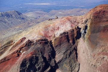
Couches de scories rouges au cratère rouge du volcan Tongariro (Photo: Tom Pfeiffer)
Eruptions du volcan Tongariro
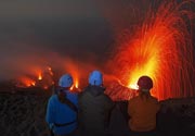
6 August 2012 eruption
A brief but violent phreatic eruption occurred at 23:50 local time on 6 August from new vents near the Te Mari crater of Tongariro.
The explosion followed several weeks of increased earthquakes under the volcano. It produced a 7 km tall ash plume and threw ballistic blocks of up to 1 m diameter to 1.5-2 km distance.
An interesting news article with eyewitness accounts and other information: First Tongariro eruption in over 100 years ...plus d'info
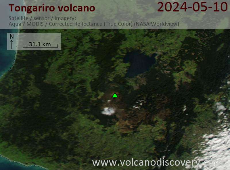
Latest satellite images