Contact | RSS | EN | DE | EL | ES | FR | IT | RU

Augustine Volcano

Updated: 19 avril. 2024 11:56 GMT -
Stratovolcano 1260 m / 4134 ft
Cook Inlet (SW Alaska), 59.36°N / -153.43°W
Condition actuelle: normal / en sommeil (1 sur 5)
Last update: 10 déc. 2021
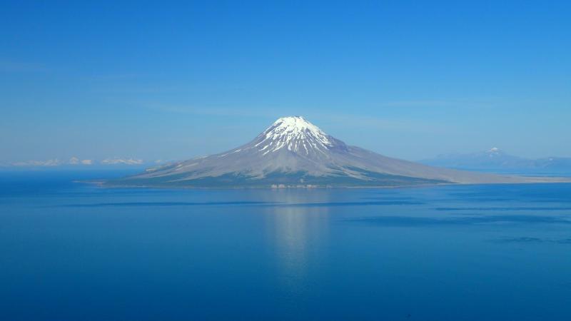
Augustine volcano (image: Peter Kelly, AVO/USGS)

Augustine is the most active volcano of the eastern Aleutian arc. It consists of several overlapping lava domes that frequently produce explosive eruptions and are notorious for collapsing, producing glowing avalanches (block and ash flows).
Augustine volcano had a devastating eruption 1883 when large parts of the summit dome complex collapsed. In the following century, several eruptions associated with dome growth have restored the volcano's height again. Historical eruptions after that date were typically explosive, producing pyroclastic pumice flows and block-and-ash flows, followed by regrowth of the lava domes.

[smaller] [larger]
Style éruptif tipique: Explosive
Eruptions du volcan Augustine: 2005-06, 1986, 1976, 1971, 1963, 1935, 1908(?), 1883-84(?), 1812

Derniers séismes proches

HeureMag. / ProfondeurDistance / Lieu
15 avril 18:03 (Anchorage)
2.0

109 km
21 km au nord 51 km ESE of Pedro Bay, Alaska
Info
samedi, 13 avril 2024 GMT (1 séisme)
13 avril 02:43 (Anchorage)
2.2

241 km
8.7 km au sud 115 km à l'ouest de Gomer, Kenai Peninsula, Alaska, États-Unis
Info
samedi, 6 avril 2024 GMT (1 séisme)
6 avril 02:51 (GMT -8)
2.5

79 km
29 km à l'est 56 km W of Nanwalek, Alaska
Info
vendredi, 5 avril 2024 GMT (1 séisme)
5 avril 08:56 (GMT -8)
2.2

99 km
23 km au nord-est 66 km W of Nanwalek, Alaska
Info
jeudi, 11 avril 2024 GMT (1 séisme)
10 avril 19:08 (Anchorage)
1.7

128 km
17 km au nord-ouest 43 km SE of Pedro Bay, Alaska
Info
mardi, 16 avril 2024 GMT (1 séisme)
16 avril 01:00 (GMT -8)
1.6

75 km
23 km à l'est 63 km W of Nanwalek, Alaska
Info

Introduction

The oldest exposed rocks on the flanks of Augustine are little more than 40,000 years old. At least 11 large debris avalanches have reached the sea during the past 1800-2000 years, and five major pumiceous tephras have been erupted during this interval.

Latest satellite images

Augustine satellite image sat1Augustine satellite image sat2

jeu., 16 oct. 2014, 08:25

Augustine volcano (Alaska): pilot reports large ash cloud, aviation color code raised to Red

Strong ash emissions from the volcano were reported by a pilot shortly after midnight (UTC). The reported height of the plume was to up to 70,000 ft (21 km) altitude, which would indicate an unexpected, and sudden major explosion took place (if the observed plume was volcanic ash and not something else). Anchorage VAAC raised the Aviation Color Code to RED. Read all
jeu., 1 janv. 1970, 00:00

Augustin volcan (Alaska) - mise à jour éruption: l'augmentation du niveau d'alerte volcanique

AVO increased the Volcanic Alert Level to Advisory and the Aviation Color Code to Yellow for Augustine on 22 September due to an increase in seismic activity below the summit over the previous week. Read all
Map of Augustine volcano, surrounding volcanoes, and surrounding communities. (Image courtesy Schaefer, Janet, Alaska Division of Geological & Geophysical Surveys.)
Photograph of Augustine's summit and the steaming lava dome, taken on 4 January, 2006 (Photo: USGS)

Sur cette page:

Découvrez notre app gratuite !
Volcanoes & Earthquakes - new app for Android
Android | Version iOS

Plus sur VolcanoDiscovery

Why is there advertising on this site?

Support us - Help us upgrade our services!

We truly love working to bring you the latest volcano and earthquake data from around the world. Maintaining our website and our free apps does require, however, considerable time and resources.
We need financing to increase hard- and software capacity as well as support our editor team. We're aiming to achieve uninterrupted service wherever an earthquake or volcano eruption unfolds, and your donations can make it happen! Every donation will be highly appreciated. If you find the information useful and would like to support our team in integrating further features, write great content, and in upgrading our soft- and hardware, please make a donation (PayPal or Online credit card payment).

Planned features:Thanks to your past donations, these features have been added recently:
Download and Upgrade the Volcanoes & Earthquakes app to get one of the fastest seismic and volcano alerts online:
Android | IOS
Thank you!
Copyright: VolcanoDiscovery ou autres sources indiquées.
Utilisation des documents: Les textes, les images et les vidéos de ce site internet sont protégées par copyright. Toute reproduction et tout usage sans accord préalable ne sont pas autorisés. Si vous désirez acquérir pour certains documents (photos, vidéos, textes ou autres) le droit de reproduction, d'édition et, plus généralement, de toute utilisation destinée à un usage public, qu'elle soit commerciale ou pas, vous êtes priés de nous contacter.
Volcanoes & Earthquakes
VolcanoDiscovery Home
Volcans | Séismes | Photos | Actualités | App
Adventure & Study Travel
Tours to Volcanoes and Volcanic Areas: walking tours, photo tours, study tours
Voyages |
Get our newsletter!
Company info
Contact | Mentions légales | Terms & conditions
Follow us
Follow us on facebook Follow us on Instagram Follow us on Twitter Visit our Youtube channel
EN | DE | EL | ES | FR | IT | RU
VolcanoDiscovery GmbH, Germany, Reg. nr.: HRB 103744, EU Tax Id: DE 297 465 123 owned and created by
Dr. Tom Pfeiffer, volcanologist, volcano photographer, tour organizer member of
IAVCEI
IAVCEI
Vulkanologische Gesellschaft
Volcanological Society
Ecotourism Greece
Ecotourism Greece
RUV insurance
Insured by R+V
VolcanoDiscovery © 2004- All Rights Reserved | Privacy