Herdubreid Volcano
Updated: 19 avril. 2024 02:49 GMT -
Tuya 1682 m / 5518 ft
Central Iceland, 65.18°N / -16.35°W
Condition actuelle: normal / en sommeil (1 sur 5)
Central Iceland, 65.18°N / -16.35°W
Condition actuelle: normal / en sommeil (1 sur 5)
[smaller] [larger]
Eruptions du volcan Herdubreid: None during the past 10,000 years
Less than few million years ago (Pleistocene)
Derniers séismes proches
| Heure | Mag. / Profondeur | Distance / Lieu | |||
| 15 avril 03:22 (Reykjavik) | 1.7 4.5 km | 2.7 km au nord-est | Info | ||
| samedi, 13 avril 2024 GMT (1 séisme) | |||||
| 13 avril 23:38 (Reykjavik) | 1.7 5.2 km | 3.5 km au nord-est | Info | ||
| mardi, 9 avril 2024 GMT (1 séisme) | |||||
| 9 avril 09:00 (Reykjavik) | 1.6 3.9 km | 23 km au sud-ouest | Info | ||
| vendredi, 5 avril 2024 GMT (1 séisme) | |||||
| 5 avril 11:32 (Reykjavik) | 1.5 12 km | 18 km au nord | Info | ||
| lundi, 15 avril 2024 GMT (1 séisme) | |||||
| 15 avril 04:34 (Reykjavik) | 1.4 4.2 km | 4.5 km au sud-ouest | Info | ||
| samedi, 13 avril 2024 GMT (1 séisme) | |||||
| 13 avril 20:04 (Reykjavik) | 1.4 4.9 km | 2.6 km au nord | Info | ||
Introduction
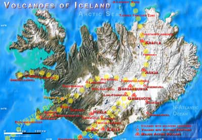
The renowned flat-topped Icelandic table mountain Herdubreid, located NE of Askja volcano, was active until the late Pleistocene.---
Source: Smithsonian / GVP volcano information


