Due to visual and instrumental monitoring results as well as level of potential hazards the Alert Level for Kelut was lowered to 1 (on a scale of 1-4) on 12 August. Residents and visitors were advised to not approach the crater rim, crater floor, or the rivers that disgorge from Kelut.
PVMBG noted that due to visual and instrumental monitoring results as well as level of potential hazards the Alert Level for Kelut was lowered to 1 (on a scale of 1-4) on 12 August. Residents and visitors were advised to not approach the crater rim, crater floor, or the rivers that disgorge from Kelut.
dim., 2 mars 2014, 10:07

Part of Kelut's crater area on 25 Feb (image: Pasang Mata)
No new explosions have occurred recently and the alert status of the volcano was lowered to 2 (Waspada, "watch") on a scale of 1-4.
Read allmer., 26 févr. 2014, 06:00
PVMBG noted that the Alert Level for Kelut was lowered to 2 (on a scale of 1-4) on 28 February.
Read allmar., 25 févr. 2014, 17:20
![The crater of Kelut volcano on 23 Feb 2014 (photo: https://twitter.com/RocknRoll_18270)]()
The crater of Kelut volcano on 23 Feb 2014 (photo: https://twitter.com/RocknRoll_18270)
An areal photo from 23 Feb shows no signs of a new lava dome, at least not near the surface of the new crater.
dim., 23 févr. 2014, 17:49
![The crater of Kelut on 18 Feb (Photo by Suwarno, a local photographer, via Oystein Lund Andersen)]()
The crater of Kelut on 18 Feb (Photo by Suwarno, a local photographer, via Oystein Lund Andersen)
Activity at the volcano has decreased, but it is still unknown what exactly the situation at the vent is, whether or not a new lava dome is forming there. The thermal hot spot visible on satellite data could also be caused by hot gasses.
Read allven., 21 févr. 2014, 10:53
![MODIS hot spot at Kelut volcano (ModVolc, Univ. Hawaii)]()
MODIS hot spot at Kelut volcano (ModVolc, Univ. Hawaii)
A MODIS hot spot is visible at the crater, suggesting that a new lava dome could be forming there. This would be the effusive continuation of the recent explosion on 13 Feb, as magma with much less gas content continues to arrive at the vent.
jeu., 20 févr. 2014, 09:53
![Degassing plume of Kelut yesterday (photo: Aris Yanto)]()
Degassing plume of Kelut yesterday (photo: Aris Yanto)
The volcano itself remains relatively calm and produces only a degassing plume. So far, no clear picture has been available about what exactly is going on at the crater itself (e.g. whether a new lava dome is forming).
Read allmer., 19 févr. 2014, 06:00
PVMBG reported that on 14 February, the day after a large eruption at Kelut that began at 2250 on 13 February, gray-to-black plumes rose 400-600 m above the crater. On 15 February grayish white plumes rose as high as 3 km. During 16-20 February white plumes rose as high as 1 km and drifted N, NE, and E.
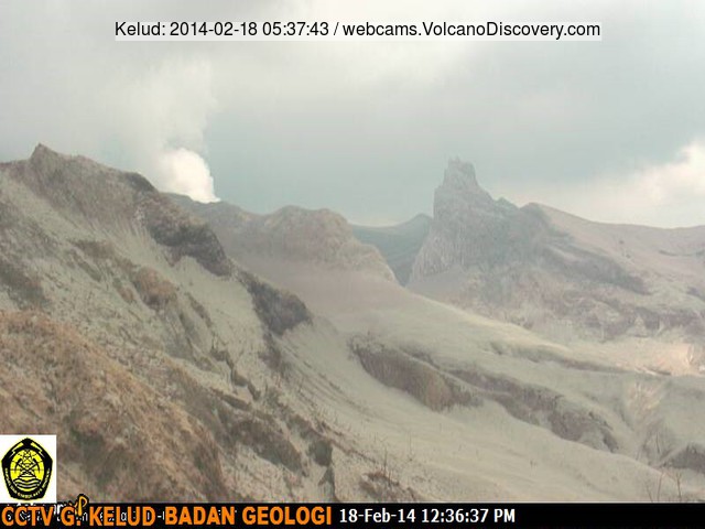
Read allmar., 18 févr. 2014, 09:25
![Steaming from Kelut this morning (new VSI webcam)]()
Steaming from Kelut this morning (new VSI webcam)
Activity has calmed down at the volcano. The
new VSI webcam shows the outer crater area covered with heavy ash deposits and only a small steam plume from the crater.
Read alldim., 16 févr. 2014, 11:12
![Steaming Kelut volcano this morning (photo: Aris Yanto)]()
Steaming Kelut volcano this morning (photo: Aris Yanto)
The volcano continues to emit a dense steam plume and some ash, but has not produced new explosions. Apart from that the 2007 lava dome has been removed by the explosion, it is not very clear (nor easy to find out) what is currently happening in the crater.
Read allsam., 15 févr. 2014, 13:42
![Ash emissions from Kelut yesterday (photo taken from Blitar)]()
Ash emissions from Kelut yesterday (photo taken from Blitar)
Additional details and new estimates about the recent explosion are emerging. Unfortunately, a 4th fatality caused by the eruption has now been confirmed by BNPB. All victims were within 7 km of the volcano. More than 100,000 people have been evacuated.
Read allven., 14 févr. 2014, 19:58
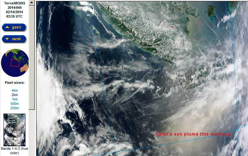
![The ash plume of Kelut over the Indian Ocean (NASA earth observatory)]()
The ash plume of Kelut over the Indian Ocean (NASA earth observatory)
Ash from the eruption is still drifting over the eastern Indian Ocean. More than 100,000 people have reportedly evacuated areas close to the volcano. Heavy ash fall occurred in vast areas of Java. A preliminary judgement of the erupted ash suggests that the explosion was a magmatic event, i.e. triggered by a new bash of fresh magma that seems to have risen very quickly to the surface:
Read allven., 14 févr. 2014, 11:32
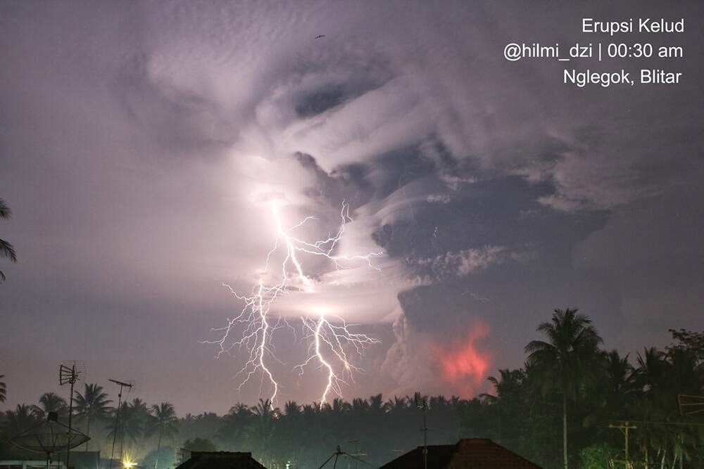
![The eruption of Kelut last night (image: pic.twitter.com/ypy7kx9615 / @hilmi_dzi)]()
The eruption of Kelut last night (image: pic.twitter.com/ypy7kx9615 / @hilmi_dzi)
BNPB (Civil protection) confirmed 3 fatalities (indirectly or directly) caused by the eruption: two as result of breathing difficulties caused by the ash, one as a road accident during evacuation. All of the victims were in Pandasari village less than 7 km from the volcano where 20 cm of ash has fallen.
Read allven., 14 févr. 2014, 07:33
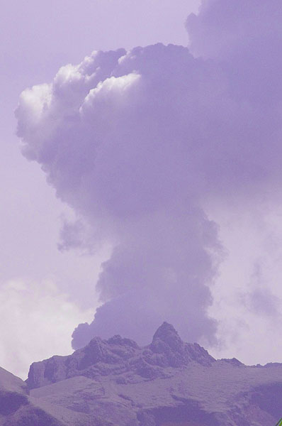
![The eruption column with intense volcanic lightning (@soranibrahim7, pic.twitter.com/11kGP8V0k4)]()
The eruption column with intense volcanic lightning (@soranibrahim7, pic.twitter.com/11kGP8V0k4)
The ash plume from last night's major eruption (possibly sub-plinian or even plinian in size) of Kelut is drifting rapidly to the west above the Indian Ocean. It is estimated to be as high as 55,000 ft (16 km) and extends several hundred kilometers in both N-S and W-E directions.
Read alljeu., 13 févr. 2014, 19:32
![The eruption column of Kelut with lightning (photo: @RagaRikardhanu/ Twitter)]()
The eruption column of Kelut with lightning (photo: @RagaRikardhanu/ Twitter)
It seems that a large eruption started at the volcano at 23:29 local time today. VAAC Darwin reports an ash plume to 45,000 ft (15 km) altitude is drifting 50 nautical miles to the west of the volcano. The alert status was raised to the highest level.
Read allmer., 12 févr. 2014, 06:00
PVMBG reported that at 2115 on 13 February the Alert Level for Kelut was raised to 4 (on a scale of 1-4). Visitors and residents were prohibited from approaching the crater within a 10-km radius. BNPB reported that a major eruption occurred less than two hours later at 2250, followed by another large explosion at 2330.
Read allmar., 11 févr. 2014, 07:35
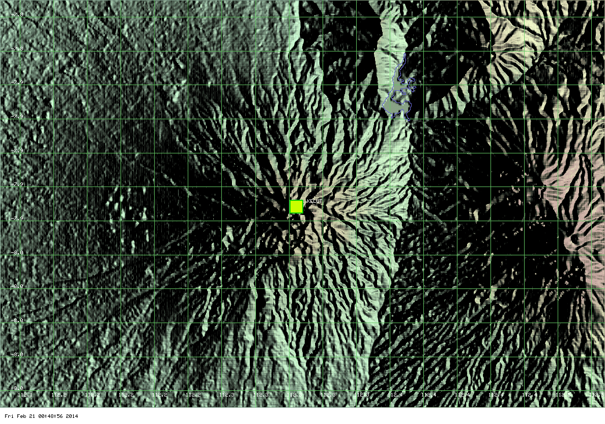
![Seismic activity at Kelut volcano during the past weeks (VSI)]()
Seismic activity at Kelut volcano during the past weeks (VSI)
VSI raised the alert status to the second highest level 3 (out of 4), "Siaga" (meaning eruption warning). In its latest report, VSI informs that an ongoing slight deformation, suggesting magma intrusion, has been detected since September and that a strong increase in seismic activity started on 7 February. A seismic swarm occurred with hypocenters between 1.5-3.5 km depth beneath the summit area.
Read allmer., 5 févr. 2014, 06:00
PVMBG reported that during 3-10 February seismic activity at Kelut was dominated by both shallow and deep volcanic earthquakes; earthquake hypocenters were 3 km below the summit. RSAM values increased on 6 and 9 February. Inflation was detected at one station.
Read alldim., 2 févr. 2014, 19:32
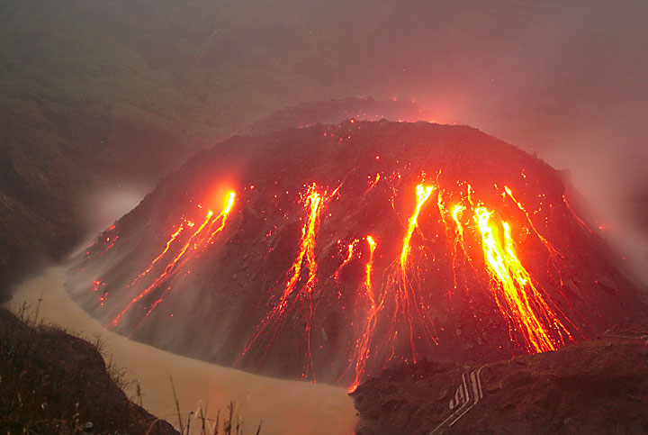
![The new lava dome of Kelut volcano in Nov 2007]()
The new lava dome of Kelut volcano in Nov 2007
The alert level of the volcano was raised today from 1 ("normal") to 2 ("Waspada", "watch") on a scale of 1-4. During the second half of 2014, a strong increase in seismic activity and a 5.5 deg temperature increase of the crater lake water had been detected.
Read allmer., 29 janv. 2014, 06:00
PVMBG reported that during 1 January-2 February the number of shallow volcanic earthquakes at Kelut increased, with peaks of seismicity occurring during 15-16 January, 28 January, and 2 February. The number of volcanic earthquakes also fluctuated but increased overall. Earthquakes occurred 2-8 km below Kelut.
Read all