Nyiragongo Volcano
Updated: 25 avril. 2024 00:36 GMT -
Stratovolcano 3470 m / 11,384 ft
DRCongo, -1.52°S / 29.25°E
Condition actuelle: en éruption (4 sur 5)
DRCongo, -1.52°S / 29.25°E
Condition actuelle: en éruption (4 sur 5)
Last update: 17 avril 2024 (Smithsonian / USGS Weekly Volcanic Activity Report)
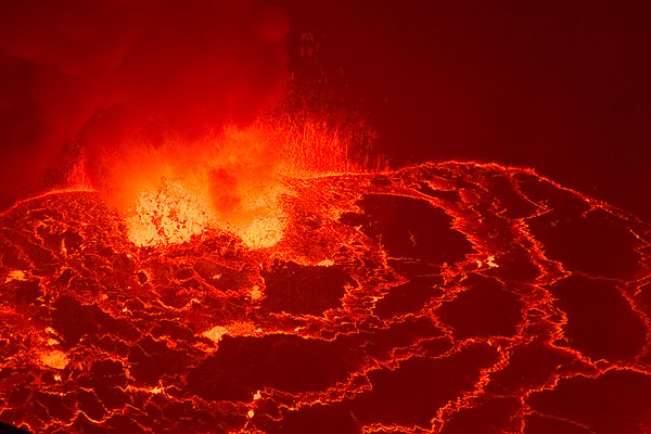
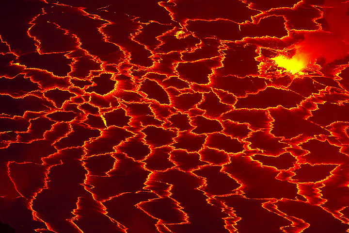
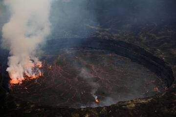
The lava lake of Nyiragongo volcano
Nyiragongo (also spelled Niragongo), one of the world's most beautiful and active volcanoes, is a large stratovolcano near Lake Kivu at the eastern border of DRCongo with Rwanda in the Virunga National Park.
It has a 1.2 km diameter summit caldera containing the world's most active and largest lava lake.
Nyiragongo is infamous for its extremely fluid lava that runs as water when the lava lake drains. On January 17, 2002, Nyiragongo erupted and the lava lake drained from fissures on its western flanks. The city centre of the Goma town, the capital of the East Virunga province, had been destroyed by voluninous lava flows. 200,000 people were left homeless, adding to the human desaster caused by frequent civil wars.
[smaller] [larger]
Nyiragongo webcams / données en temps réel | News | Updates | Earthquakes | Volcano videos | Tours | Images
Style éruptif tipique: Large effusive eruptions; persistant lava lake in the summit crater.Eruptions du volcan Nyiragongo: 1884, 1894, 1898, 1899, 1900, 1901, 1902, 1905, 1906, 1908(?), 1911, 1918, 1920-21, 1927-77, 1977, 1982, 1994-96, 2002 (17 Jan-3 Feb, south flank), 2002-2021 (lava lake), 2021 (22-23 May, flank eruption)
Derniers séismes proches
| Heure | Mag. / Profondeur | Distance / Lieu | |||
Introduction
Nyiragongo, located in the Western branch of the Rift Valley near Lake Kivu and the Congolese-Rwandese border, is one of the world's most active volcanoes. It is notorious for its lava lake and producing lateral eruptions with extremely fluid, fast-moving lava flows that repeatedly devastated areas around the volcano, such as the Goma desaster on January 2002, when a lava flow destroyed much of the city's commercial center and promted 200,000 people to flee.The large lava lake contained in its deep summit crater, now active again, became famous in the 1960's and 70's when volcanologists such as the Kraffts and Tazieff studied it. It had been active for half a century before it drained in one of the volcano's recent most catastrophic eruptions in 1977: through openings in its outer flanks in 1977, a huge lava flow poured out and killed hundreds of people. A similar event happened again in January 2002, when lava flows from flank vents drained the lake and cut through Goma, reaching Lake Kivu.
In contrast to its neighbor volcano, Nyamuragira,- a typical, and very active shield volcano comparable with Mauna Loa,- the 3470-m-high Nyiragongo displays the steep slopes of a stratovolcano. Terraces inside the steep-walled, 1.2-km-wide summit crater mark levels of former lava lakes, which have been observed since the late-19th century.
Two older volcanoes, Baruta and Shaheru, are partially overlapped by Nyiragongo on the north and south and look like lateral cones. About 100 parasitic cones are located primarily along radial fissures south of Shaheru, east of the summit, and along a NE-SW zone extending as far as Lake Kivu. Many cones are buried by voluminous lava flows that extend long distances down the flanks of the volcano.
Nyiragongo Volcano Photos
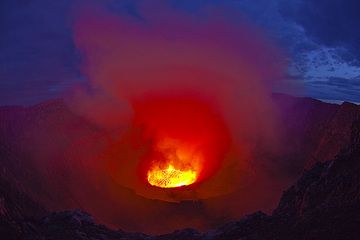
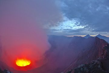
À l'approche du matin, la lumière intense rouge et jaune de la lave se mélange à nouveau au bleu du ciel, créant un spectacle unique. (Photo: Tom Pfeiffer)
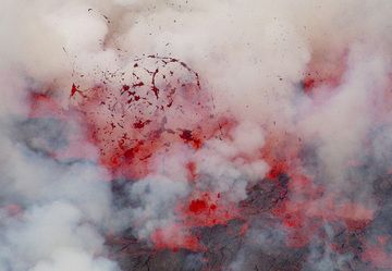
Encore le lac de lave Nyiragongo. La lueur rouge de la lave était clairement visible toute la journée. (Photo: shinkov)
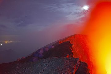
Les lumières de la ville de Goma en arrière-plan à gauche me rappellent que je me trouvais sur le volcan Etna et que je regardais Catane... (Photo: Tom Pfeiffer)
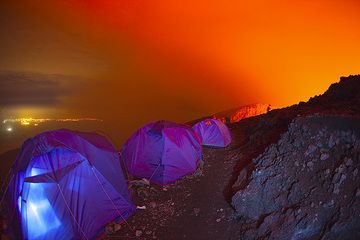
Il est temps de se réveiller et de profiter de la dernière heure d'obscurité avant le lever du soleil ! Comme d'habitude, Gilles est déjà debout avant tous les autres et ...
Latest satellite images

Nyiragongo Volcano Tours
République Démocratique du Congo et Rwanda
Le Grand Lac de Lave du Nyiragongo
Expédition sur le volcan Nyiragongo et dans le parc des Virunga (gorilles de montagne)
6-8 jours - Modérée-Soutenu
Prix $ 3950
Prix $ 3950
pas de groupe programmé pour le moment