


Atitlán Volcano
Updated: 24 apr. 2024 22:02 GMT -
Stratovolcano 3535 m / 11,598 ft
Guatemala, 14.58°N / -91.19°W
Current status: normal or dormant (1 out of 5)
Guatemala, 14.58°N / -91.19°W
Current status: normal or dormant (1 out of 5)
[smaller] [larger]
Eruzioni del vulcano Atitlán: 1853
Latest nearby earthquakes
| Data / ora | Mag. / Prof. | Distanza / Ubicazione | |||
Background
Volcán Atitlán is one of several prominent conical stratovolcanoes in the Guatemalan highlands. Along with its twin volcano Tolimán to the north, it forms a dramatic backdrop to Lake Atitlán, one of the scenic highlights of the country. The 3535-m-high summit of Atitlán directly overlies the inferred margin of the Pleistocene Atitlán III caldera and is the highest of three large post-caldera stratovolcanoes constructed near the southern caldera rim. The volcano consequently post-dates the eruption of the voluminous, roughly 85,000-year-old rhyolitic Los Chocoyos tephra associated with formation of the Atitlán III caldera. The historically active andesitic Volcán Atitlán is younger than Tolimán, although their earlier activity overlapped. In contrast to Tolimán, Atitlán displays a thick pyroclastic cover. The northern side of the volcano is wooded to near the summit, whereas the upper 1000 m of the southern slopes are unvegetated. Predominantly explosive eruptions have been recorded from Volcán Atitlán since the 15th century.---
Smithsonian / GVP volcano information
Atitlán Volcano Photos
Vulcani Atitlán, Toliman e San Pedro (Photo: Tom Pfeiffer)

La mattina presto sulla riva del lago Atitlán con i vulcani Atitlán, Toliman e San Pedro sullo sfondo (Photo: Tom Pfeiffer)

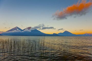
Alba sul lago Atitlán con i vulcani Atitlán e Toliman sullo sfondo (Photo: Tom Pfeiffer)

I vulcani Atitlán e Toliman visti dalla riva del lago Atitlán (Photo: Tom Pfeiffer)
Latest satellite images

Atitlán Volcano Tours
Guatemala
Guatemala Volcano Special
11-day volcano tour to Pacaya and Fuego, Guatemala
8-12 days - Moderate to Challenging
Price $ 3490
Price $ 3490
no scheduled dates at present


