Galunggung Volcano
Updated: 19 apr. 2024 04:07 GMT -
Stratovolcano 2168 m / 7,113 ft
Giava occidentale (Indonesia), -7.25°S / 108.06°E
Current status: normal or dormant (1 out of 5)
Giava occidentale (Indonesia), -7.25°S / 108.06°E
Current status: normal or dormant (1 out of 5)
Last update: 9 dic 2021 (decreasing activity, alert level lowered back to normal (green))
Galunggung volcano about 100 km SE of West Java's capital Bandung had its last major eruption in 1982, when ash plumes reached 20 km.
[smaller] [larger]
Eruzioni del vulcano Galunggung: 1984, 1982-83 (VEI 4), 1918, 1894, 1822
Latest nearby earthquakes
| Data / ora | Mag. / Prof. | Distanza / Ubicazione | |||
Background
Galunggung volcano is a forested cone cut by a large horseshoe-shaped caldera breached to the SE where most pyroclastic flows from recent eruptions were channeled.The "Ten Thousand Hills of Tasikmalaya" dotting the plain below the volcano are hill-size deposits (hummocks) left by a large debris-avalanche associated with the collapse forming the caldera ca. 4200 years ago.
Historical eruptions have been restricted to the central vent near the caldera headwall. The eruptions from Galunggung have often caused much damage: The first historical eruption in 1822 produced pyroclastic flows and lahars that killed over 4000 persons. Its last major eruption in 1982-1983 produced devastating pyroclastic flows causing large-scale damage in the populated areas around the volcano.
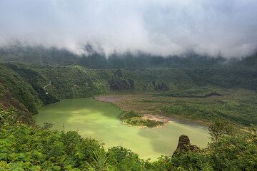
Galunggung Volcano Photos

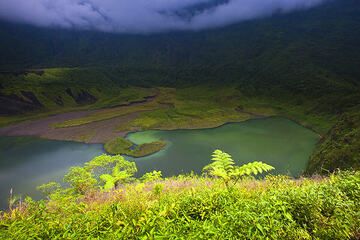
Il lago del cratere del vulcano Galunggung (Photo: Ivana Dorn)
Vulcano Galunggung e nuvole basse (Photo: Uwe Ehlers / geoart.eu)
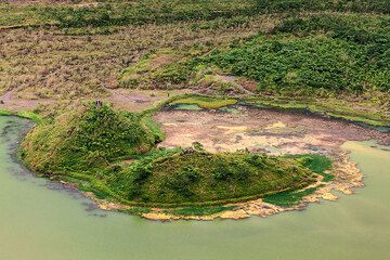
Lago craterico del vulcano Galunggung (Photo: Uwe Ehlers / geoart.eu)
Cratere del vulcano Galunggung, Giava Occidentale, Indonesia (Photo: Roland Gerth)
Eruzioni del vulcano Galunggung
April 1982 - Jan 1983 eruption
The 1982-1983 eruption was a series of violent explosions with tall ash plumes and pyroclastic flows and mud flows. It killed at least 21 people, caused evacuation of 40,000 people and destroyed ca 94,000 ha of cultivated land. ...Ulteriori info
The 1982-1983 eruption was a series of violent explosions with tall ash plumes and pyroclastic flows and mud flows. It killed at least 21 people, caused evacuation of 40,000 people and destroyed ca 94,000 ha of cultivated land. ...Ulteriori info
Aircraft ash encounter at Galunggung volcano - near fatal accident with Boing 474
On 24 June 1982, a Boeing 747 flew through Galunggung's undetected ash plume, which caused all four engines to fail. Fortunately, the engines could be restarted after the plane had lost 25,000 ft and came into denser air, and the crew managed a successful emergency landing, saving the lives of 263 people. This and a similar accident over Alaska raised awareness of the need to monitor volcanic ash plumes, which lead to the formation of the Volcanic Ash Advisory Centres (VAAC). ...Ulteriori info
On 24 June 1982, a Boeing 747 flew through Galunggung's undetected ash plume, which caused all four engines to fail. Fortunately, the engines could be restarted after the plane had lost 25,000 ft and came into denser air, and the crew managed a successful emergency landing, saving the lives of 263 people. This and a similar accident over Alaska raised awareness of the need to monitor volcanic ash plumes, which lead to the formation of the Volcanic Ash Advisory Centres (VAAC). ...Ulteriori info
Latest satellite images