Contatti | RSS | EN | DE | EL | ES | FR | IT | RU

Lewotolo Volcano

Updated: 18 apr. 2024 21:59 GMT -
stratovolcano 1423 m / 4,669 ft
Piccole Isole della Sonda (Indonesia), -8.27°S / 123.51°E
Current status: erupting (4 out of 5)
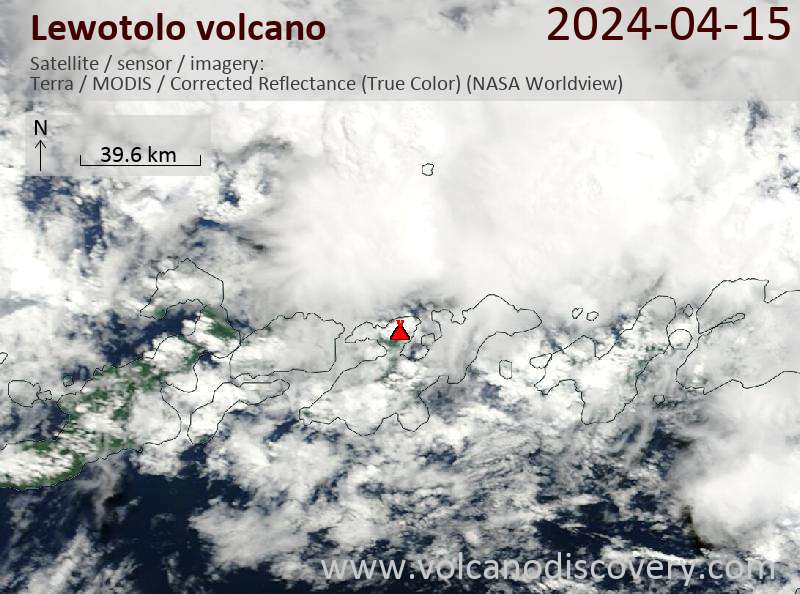
Last update: 15 apr 2024 (Volcanic Ash Advisory)

Lewotolo (or Ile Api Lewotolok) volcano on the eastern end of a peninsula of Lembata (formerly Lomblen) Island forms a perfect symmetrical cone. The stratovolcano has 2 craters of 900x800 m and 250x200 m in diameter.
Many lava flows have reached the coastline. Historical eruptions, recorded since 1660, have consisted of explosive activity from the summit crater.

[smaller] [larger]
Typical eruption style: Explosive
Eruzioni del vulcano Lewotolo: 2012, 1951, 1920, 1899, 1864, 1852, 1849, 1819, 1660

Latest nearby earthquakes

Data / oraMag. / Prof.Distanza / Ubicazione
10 apr 15:18 (Makassar)
3.5

90 km
30 km a sud-est Flores Region, Indonesia
Info

Background

Lewotolo's lavas are remarkable because they contain the rare mineral zirconolite (CaZrTi2O7).
Source/literature:
"Volatile-induced transport of HFSE, REE, Th and U in arc magmas: evidence from zirconolite-bearing vesicles in potassic lavas of Lewotolo volcano (Indonesia)" Jan C. M. de Hoog and Manfred J. van Bergen, Contributions to Mineralogy and Petrology, Volume 139, Number 4, 485-502

Lewotolo Volcano Photos
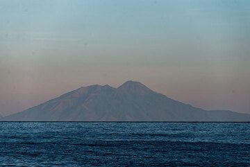
Latest satellite images

Lewotolo satellite image sat1Lewotolo satellite image sat2
Lewotolo Volcano Tours
Flores, Indonesia
Indonesia Volcano Special
Volcano expedition to Lewotobi and Ile Lewotolok volcanoes in Feb 2024
7 days (10 days with extension) - Moderate
Price 1750 EUR (7d) / 2480 EUR (10d)
no scheduled dates at present
Try our free app!
Volcanoes & Earthquakes - new app for Android
Android | iOS version

Piu su VolcanoDiscovery

Why is there advertising on this site?

Support us - Help us upgrade our services!

We truly love working to bring you the latest volcano and earthquake data from around the world. Maintaining our website and our free apps does require, however, considerable time and resources.
We need financing to increase hard- and software capacity as well as support our editor team. We're aiming to achieve uninterrupted service wherever an earthquake or volcano eruption unfolds, and your donations can make it happen! Every donation will be highly appreciated. If you find the information useful and would like to support our team in integrating further features, write great content, and in upgrading our soft- and hardware, please make a donation (PayPal or Online credit card payment).

Planned features:Thanks to your past donations, these features have been added recently:
Download and Upgrade the Volcanoes & Earthquakes app to get one of the fastest seismic and volcano alerts online:
Android | IOS
Thank you!
Sources: VolcanoDiscovery / VolcanoAdventures and other sources as noted.
Use of material: Most text and images on our websites are owned by us. Re-use is generally not permitted without authorization. Contact us for licensing rights.
Volcanoes & Earthquakes
VolcanoDiscovery Home
Vulcani | Earthquakes | Photos | News | App
Adventure & Study Travel
Tours to Volcanoes and Volcanic Areas: walking tours, photo tours, study tours
Tours & Dates | FAQ | About us
Get our newsletter!
Company info
Contact | Legal info | Terms & conditions
Follow us
Follow us on facebook Follow us on Instagram Follow us on Twitter Visit our Youtube channel
EN | DE | EL | ES | FR | IT | RU
VolcanoDiscovery GmbH, Germany, Reg. nr.: HRB 103744, EU Tax Id: DE 297 465 123 owned and created by
Dr. Tom Pfeiffer, volcanologist, volcano photographer, tour organizer member of
IAVCEI
IAVCEI
Vulkanologische Gesellschaft
Volcanological Society
Ecotourism Greece
Ecotourism Greece
RUV insurance
Insured by R+V
VolcanoDiscovery © 2004- All Rights Reserved | Privacy - Cookie Settings