


Lipari Volcano
Updated: 23 apr. 2024 18:06 GMT -
stratovolcano 602 m
Isole Eolie (Italia), 38.51°N / 14.95°E
Current status: normal or dormant (1 out of 5)
Isole Eolie (Italia), 38.51°N / 14.95°E
Current status: normal or dormant (1 out of 5)
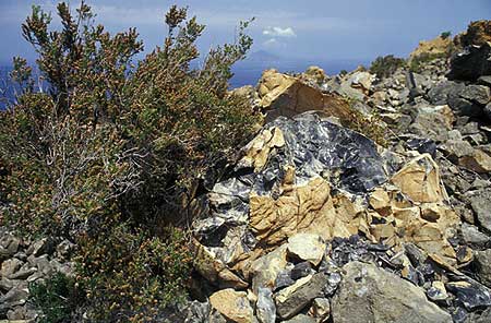
Obsidian block from the Rocce Rosse lava flow on Lipari Island
Lipari, the ancient Meligunis, is the largest island of the Eolian Archipelago and its economic and cultural center.
[smaller] [larger]
Eruzioni del vulcano Lipari: 729 AD (?, alternative date: 580 AD) at Monte Pilato, formation of "Rocce Rosse" obsidian flow
Latest nearby earthquakes
| Data / ora | Mag. / Prof. | Distanza / Ubicazione | |||
| 16 apr 21:19 (Rome) | 2.2 12 km | 8.8 km a est | Info | ||
| 16 apr 08:00 (Rome) | 2.0 12 km | 8.9 km a est | Info | ||
Background
It is located immediately north of Vulcano Island. The island contains numerous small stratovolcanoes, craters, and lava domes on a basement of submarine volcanic deposits.The latest eruption in historic times, probably in 729 AD, at Monte Pilatus at the NE tip of the island, formed a spectacular obsidian lava flow. Since Ancient times, the island has been known for its rich deposit of pumice (the largest deposit in the world!) and obsidian, - a highly valued raw material to manufacture tools such as knives and arrowheads in the Stone and Bronze Age. Obsidian from Lipari has been found throughout the Mediterranean, proving that a vast trade network existed already during the 2nd millennium BC.
Lipari Volcano Photos
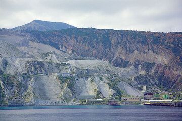
Vecchie cave di pomice a Monte Pilato a Lipari (Photo: Tom Pfeiffer)
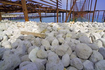
Ciottoli di pomice sulla spiaggia sotto il vecchio molo arrugginito della cava di pomice a Lipari (Photo: Tom Pfeiffer)
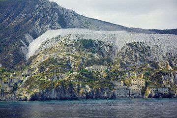
Le cave di pomice di Lipari e la colata lavica di ossidiana "Rocce Rosse" (Photo: Tom Pfeiffer)

Porto peschereccio di Lipari ("Marina Corta") (Photo: Tom Pfeiffer)
Latest satellite images
Lipari Volcano Tours
Naples, Eolian Islands, Etna (Italy)
Volcanoes of Italy - the Grand Tour
15-day study & walking tour to Italy's volcanoes from Vesuvius to Etna
15 days (14 nights) - Easy to Moderate
Price 3890 €
Price 3890 €
3-17 ott 2025
Eolian Islands + Etna volcano
From Stromboli to Etna
walking & study tour with a volcanologist to Etna, Vulcano, Lipari and Stromboli
9 days (8 nights) - Easy to Moderate
Price 2950 €
Price 2950 €
18-26 mag 2024
3-11 mag 2025
12-20 ott 2024


