Contatti | RSS | EN | DE | EL | ES | FR | IT | RU

Montagu Island Volcano

Updated: 18 apr. 2024 10:00 GMT -
Shield volcano 1370 m / 4,495 ft
UK, South Sandwich Islands, -58.42°S / -26.33°W
Current status: normal or dormant (1 out of 5)
Last update: 9 dic 2021 (Smithsonian / USGS Weekly Volcanic Activity Report)

[smaller] [larger]
Typical eruption style: unspecified
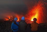
Eruzioni del vulcano Montagu Island: 2007

Latest nearby earthquakes

Non terremoti recenti
Data / oraMag. / Prof.Distanza / Ubicazione

Background

The largest of the South Sandwich Islands, Montagu consists of a massive shield volcano cut by a 6-km-wide ice-filled summit caldera. The summit of the 10 x 12 km wide island rises about 3000 m from the sea floor between Bristol and Saunders Islands. Around 90% of the island is ice-covered; glaciers extending to the sea typically form vertical ice cliffs. The name Mount Belinda has been applied both to the high point at the southern end of the summit caldera and to the young central cone. Mount Oceanite, an isolated 900-m-high peak with a 270-m-wide summit crater, lies at the SE tip of the island and was the source of lava flows exposed at Mathias Point and Allen Point. There was no record of Holocene or historical eruptive activity at Montagu until MODIS satellite data, beginning in late 2001, revealed thermal anomalies consistent with lava lake activity that has been persistent since then. Apparent plumes and single anomalous pixels were observed intermittently on AVHRR images during the period March 1995 to February 1998, possibly indicating earlier unconfirmed and more sporadic volcanic activity.
---
Smithsonian / GVP volcano information

Latest satellite images

montaguisland satellite image sat1montaguisland satellite image sat2
Wed, 9 Nov 2005, 06:00

Montagu Island volcano (South Sandwich Islands, UK) - Smithsonian / USGS Weekly Volcanic Activity Report for 9 November-15 November 2005 (Continuing Activity)

A partly cloudy ASTER satellite image from 3 November appeared to indicate that large-scale effusive activity from the summit of Montagu Island (Mt. Belinda) had ceased. The image showed that the 3.5-km-long lava flow noted in previous reports (observed entering the sea in an image from 23 September 2005) had extended the shoreline on the N side of island. ... Read all
Wed, 12 Oct 2005, 06:00

Montagu Island volcano (South Sandwich Islands, UK) - Smithsonian / USGS Weekly Volcanic Activity Report for 12 October-18 October 2005 (Continuing Activity)

An ASTER satellite image from 23 September showed a 3.5-km-long lava flow extending from the summit of Montagu Island (Mt. Belinda) into the sea. This was the largest effusive event observed during the 4-year-old eruption. ... Read all

Su questa pagina:

Try our free app!
Volcanoes & Earthquakes - new app for Android
Android | iOS version

Piu su VolcanoDiscovery

Why is there advertising on this site?

Support us - Help us upgrade our services!

We truly love working to bring you the latest volcano and earthquake data from around the world. Maintaining our website and our free apps does require, however, considerable time and resources.
We need financing to increase hard- and software capacity as well as support our editor team. We're aiming to achieve uninterrupted service wherever an earthquake or volcano eruption unfolds, and your donations can make it happen! Every donation will be highly appreciated. If you find the information useful and would like to support our team in integrating further features, write great content, and in upgrading our soft- and hardware, please make a donation (PayPal or Online credit card payment).

Planned features:Thanks to your past donations, these features have been added recently:
Download and Upgrade the Volcanoes & Earthquakes app to get one of the fastest seismic and volcano alerts online:
Android | IOS
Thank you!
Sources: VolcanoDiscovery / VolcanoAdventures and other sources as noted.
Use of material: Most text and images on our websites are owned by us. Re-use is generally not permitted without authorization. Contact us for licensing rights.
Volcanoes & Earthquakes
VolcanoDiscovery Home
Vulcani | Earthquakes | Photos | News | App
Adventure & Study Travel
Tours to Volcanoes and Volcanic Areas: walking tours, photo tours, study tours
Tours & Dates | FAQ | About us
Get our newsletter!
Company info
Contact | Legal info | Terms & conditions
Follow us
Follow us on facebook Follow us on Instagram Follow us on Twitter Visit our Youtube channel
EN | DE | EL | ES | FR | IT | RU
VolcanoDiscovery GmbH, Germany, Reg. nr.: HRB 103744, EU Tax Id: DE 297 465 123 owned and created by
Dr. Tom Pfeiffer, volcanologist, volcano photographer, tour organizer member of
IAVCEI
IAVCEI
Vulkanologische Gesellschaft
Volcanological Society
Ecotourism Greece
Ecotourism Greece
RUV insurance
Insured by R+V
VolcanoDiscovery © 2004- All Rights Reserved | Privacy - Cookie Settings