Tajumulco Volcano
Updated: Apr 23, 2024 18:06 GMT -
Stratovolcano 4220 m / 13,845 ft
Guatemala, 15.03°N / -91.9°W
Current status: normal or dormant (1 out of 5)
Guatemala, 15.03°N / -91.9°W
Current status: normal or dormant (1 out of 5)
[smaller] [larger]
Tajumulco volcano eruptions: unknown, no recent eruptions
Latest nearby earthquakes
| Time | Mag. / Depth | Distance / Location | |||
| Apr 10, 04:04 am (Guatemala) | 2.4 149 km | 19 km (12 mi) to the N | Info | ||
Background
Tajumulco is Guatemala's highest peak and the highest volcano in Central America. Two summits, one with a 50-70 m wide crater, lie along a NW-SE line. A lava flow from the 4220-m-high NW summit traveled down a deep valley on the NW flank. The andesitic-dacitic volcano was constructed over the NW end of a large arcuate SW-facing escarpment of uncertain origin. Tajumulco has had several unconfirmed reports of historical eruptions. Sapper (1917) considered Tajumulco to have erupted during historical time, but without accurate dates. The volcano was reported to eject many rocks, destroying houses on October 24, 1765, but this may have been a rock avalanche. Juarros reported some eruptions before 1808, and there are unlikely reports of eruptions in 1821 (or 1822), 1863, and 1893 (Incer 1988, unpublished manuscript).---
Smithsonian / GVP volcano information
Tajumulco Volcano Photos
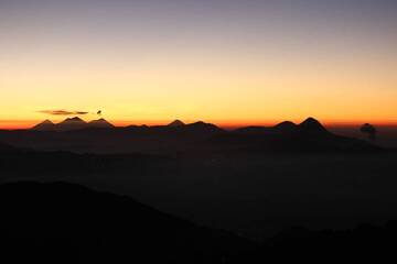
10. Distant View Of The Volcanoes From The Summit Of Volcan Tajumulco 4220m At Sunrise - From Right To Left - Santaguito (Erupting), Santa Maria, Santo Tomas, Zunil, Atit...
Latest satellite images