Связаться | RSS | EN | DE | EL | ES | FR | IT | RU

Arenal Volcano

Updated: 25 апр 2024 05:34 GMT -
Stratovolcano 1657 m / 5,436 ft
Costa Rica, 10.46°N / -84.7°W
Current status: normal or dormant (1 out of 5)
Last update: 9 дек 2021
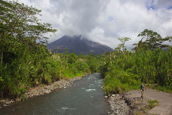
Arenal volcano seen from Rio Caliente

Arenal, a major tourist attraction in Costa Rica, is one of the most active volcanoes of Central America. Since a major eruption in 1968, it has been in near-continuous activity building a lava dome and displaying mild explosive activity from the summit crater.

[smaller] [larger]
Typical eruption style: Explosive. Near continuous strombolian activity, occasional major explosive events and lava flows.
Arenal volcano eruptions: 1968-2011, 1968 (major explosion), 1922, 1915(?), 1750, 1530, around 1350 (large, sub-Plinian eruption)

Latest nearby earthquakes

ВремяМагнитуда / ГлубинаРасстояние / Местоположение
22 апр 09:12 (Costa Rica)
3.3

7 km
1.6 km к западу Costa Rica: 8 km al Oeste de Fortuna, San Carlos.  I FELT IT
Более
Воскресенье, 21 апреля 2024 GMT (3 земл.)
21 апр 02:19 (Costa Rica)
3.3

95 km
13 km к северу Costa Rica: 62 Km al sur de San Carlos, Nicaragua  I FELT IT - 1 отчетов
Более
21 апр 02:19 (Costa Rica)
4.3

116 km
7.5 km к северо-западу Costa Rica: 4 km al Sur de Venado, San Carlos.  I FELT IT
Более
20 апр 21:16 (Costa Rica)
3.1

9 km
11 km к западу Costa Rica: 11 km al Sur de Venado, San Carlos.  I FELT IT
Более
Пятница, 19 апреля 2024 GMT (1 земл.)
19 апр 11:14 (Costa Rica)
3.0

11 km
Costa Rica: 7 km al Noreste de Venado, San Carlos.  I FELT IT
Более
Четверг, 11 апреля 2024 GMT (1 земл.)
11 апр 13:31 (Costa Rica)
2.5

7 km
Costa Rica: 4 km al Norte de Monteverde, Puntarenas.
Более

Background

Volcán Arenal, a beautiful, 1657-m high conical andesitic stratovolcano near Lake Arena, is the youngest and one of the most active stratovolcano in Costa Rica. It is famous for a large explosive eruption in 1968 that killed several people and threw incandescent bombs to 5 km distance from the vent.
Arenal lies along a volcanic chain where activity has migrated to the NW over the past 2 million years, from the late-Pleistocene Los Perdidos lava domes through the Pleistocene-to-Holocene Chato volcano, which contains a 500-m-wide, lake-filled summit crater. The earliest known eruptions of Arenal took place about 7000 years ago, and it was active simulataneously with Cerro Chato volcano until the activity of Chato ended about 3500 years ago.
Growth of Arenal has been characterized by periodic major explosive eruptions at several-hundred-year intervals and periods of lava effusion that armor the cone. Arenal's most recent eruptive period began with a major explosive eruption in 1968. Continuous explosive activity accompanied by slow lava effusion and the occasional emission of pyroclastic flows has occurred since then from vents at the summit and on the upper western flank.
Source: GVP, Smithsonian Institution

Latest satellite images

Arenal satellite image sat1Arenal satellite image sat2

Wed, 18 Sep 2013, 10:59

Arenal volcano (Costa Rica): increased rockfalls as possible sign of volcano becoming more active

OVSICORI отметил, что камнепады с грохот шум увеличились на вулкан в течение последних недель. Это может предполагать, что вулкан начал просыпаться от его 3 лет спячки. ... Read all
Thu, 12 Sep 2013, 08:14

Arenal volcano (Costa Rica) activity update

OVSICORI-Уна сообщил, что шлейфы состоит в основном из водяного пара выросла с NE и SE края кратера C Ареналь на 8 и 9 сентября. На 8 сентября были обнаружены толчки свидетельствует о гидротермальных и магматической активности. Read all

На этой странице:

Попробуйте наше бесплатное приложение!
Volcanoes & Earthquakes - new app for Android
Android | версия iOS

Подробнее о VolcanoDiscovery

Why is there advertising on this site?

Support us - Help us upgrade our services!

We truly love working to bring you the latest volcano and earthquake data from around the world. Maintaining our website and our free apps does require, however, considerable time and resources.
We need financing to increase hard- and software capacity as well as support our editor team. We're aiming to achieve uninterrupted service wherever an earthquake or volcano eruption unfolds, and your donations can make it happen! Every donation will be highly appreciated. If you find the information useful and would like to support our team in integrating further features, write great content, and in upgrading our soft- and hardware, please make a donation (PayPal or Online credit card payment).

Planned features:Thanks to your past donations, these features have been added recently:
Download and Upgrade the Volcanoes & Earthquakes app to get one of the fastest seismic and volcano alerts online:
Android | IOS
Thank you!
Sources: VolcanoDiscovery / VolcanoAdventures and other sources as noted.
Use of material: Most text and images on our websites are owned by us. Re-use is generally not permitted without authorization. Contact us for licensing rights.
Volcanoes & Earthquakes
VolcanoDiscovery Home
Вулканы | Землетрясения | Photos | News | App
Adventure & Study Travel
Tours to Volcanoes and Volcanic Areas: walking tours, photo tours, study tours
Tours & Dates | FAQ | About us
Get our newsletter!
Company info
Contact | Legal info | Terms & conditions
Follow us
Follow us on facebook Follow us on Instagram Follow us on Twitter Visit our Youtube channel
EN | DE | EL | ES | FR | IT | RU
VolcanoDiscovery GmbH, Germany, Reg. nr.: HRB 103744, EU Tax Id: DE 297 465 123 owned and created by
Dr. Tom Pfeiffer, volcanologist, volcano photographer, tour organizer member of
IAVCEI
IAVCEI
Vulkanologische Gesellschaft
Volcanological Society
Ecotourism Greece
Ecotourism Greece
RUV insurance
Insured by R+V
VolcanoDiscovery © 2004- All Rights Reserved | Privacy - Cookie Settings