Связаться | RSS | EN | DE | EL | ES | FR | IT | RU

Tajumulco Volcano

Updated: 16 апр 2024 07:40 GMT -
Stratovolcano 4220 m / 13,845 ft
Guatemala, 15.03°N / -91.9°W
Current status: normal or dormant (1 out of 5)

[smaller] [larger]
Typical eruption style: unspecified
Tajumulco volcano eruptions: unknown, no recent eruptions

Latest nearby earthquakes

ВремяМагнитуда / ГлубинаРасстояние / Местоположение
10 апр 04:04 (Guatemala)
2.4

149 km
19 km к северу 26 Km al norte de San Marcos, Guatemala
Более
Четверг, 4 апреля 2024 GMT (1 земл.)
4 апр 06:50 (Guatemala)
3.0

158 km
24 km к северу 36 Km al noroeste de San Marcos, Guatemala
Более

Background

Tajumulco is Guatemala's highest peak and the highest volcano in Central America. Two summits, one with a 50-70 m wide crater, lie along a NW-SE line. A lava flow from the 4220-m-high NW summit traveled down a deep valley on the NW flank. The andesitic-dacitic volcano was constructed over the NW end of a large arcuate SW-facing escarpment of uncertain origin. Tajumulco has had several unconfirmed reports of historical eruptions. Sapper (1917) considered Tajumulco to have erupted during historical time, but without accurate dates. The volcano was reported to eject many rocks, destroying houses on October 24, 1765, but this may have been a rock avalanche. Juarros reported some eruptions before 1808, and there are unlikely reports of eruptions in 1821 (or 1822), 1863, and 1893 (Incer 1988, unpublished manuscript).
---
Smithsonian / GVP volcano information

Tajumulco Volcano Photos
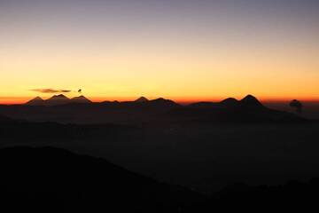
Latest satellite images

tajumulco satellite image sat1tajumulco satellite image sat2

No news in this list.

На этой странице:

Попробуйте наше бесплатное приложение!
Volcanoes & Earthquakes - new app for Android
Android | версия iOS

Подробнее о VolcanoDiscovery

Why is there advertising on this site?

Support us - Help us upgrade our services!

We truly love working to bring you the latest volcano and earthquake data from around the world. Maintaining our website and our free apps does require, however, considerable time and resources.
We need financing to increase hard- and software capacity as well as support our editor team. We're aiming to achieve uninterrupted service wherever an earthquake or volcano eruption unfolds, and your donations can make it happen! Every donation will be highly appreciated. If you find the information useful and would like to support our team in integrating further features, write great content, and in upgrading our soft- and hardware, please make a donation (PayPal or Online credit card payment).

Planned features:Thanks to your past donations, these features have been added recently:
Download and Upgrade the Volcanoes & Earthquakes app to get one of the fastest seismic and volcano alerts online:
Android | IOS
Thank you!
Sources: VolcanoDiscovery / VolcanoAdventures and other sources as noted.
Use of material: Most text and images on our websites are owned by us. Re-use is generally not permitted without authorization. Contact us for licensing rights.
Volcanoes & Earthquakes
VolcanoDiscovery Home
Вулканы | Землетрясения | Photos | News | App
Adventure & Study Travel
Tours to Volcanoes and Volcanic Areas: walking tours, photo tours, study tours
Tours & Dates | FAQ | About us
Get our newsletter!
Company info
Contact | Legal info | Terms & conditions
Follow us
Follow us on facebook Follow us on Instagram Follow us on Twitter Visit our Youtube channel
EN | DE | EL | ES | FR | IT | RU
VolcanoDiscovery GmbH, Germany, Reg. nr.: HRB 103744, EU Tax Id: DE 297 465 123 owned and created by
Dr. Tom Pfeiffer, volcanologist, volcano photographer, tour organizer member of
IAVCEI
IAVCEI
Vulkanologische Gesellschaft
Volcanological Society
Ecotourism Greece
Ecotourism Greece
RUV insurance
Insured by R+V
VolcanoDiscovery © 2004- All Rights Reserved | Privacy - Cookie Settings