Volcano Calendar 2019 We're proud to present our 2019 volcano calendar: 13 different and attractive images of volcanoes, volcanic landscapes and phenomena taken during volcano tours over the past few years.
The subplinian eruption of Kelut volcano Fascinating satellite images, reports, and pictures about the massive explosion of Kelut volcano in East Java on 13 Feb 2014.
Photos from Vanuatu A fascinating archipelago with very active volcanoes, tropical islands and very friendly and hospital people who still live their original Melanesian culture. Browse through our vast collection of photos.
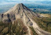
Colima volcano photos This beautiful stratovolcano in western Mexico is one of the most active volcanoes on the American continents. It is known for its often spectacular explosions and sometimes glowing avalanches.