Kirishima Volcán
Kirishima (霧島 in Japanese, Kirishimayama), one of Japan's most active volcanoes. It is actually a group of 18 young, small stratovolcanoes north of Kagoshima Bay: Takachihonomine, Nakadake, Ohatayama, Karakunidake, Tairoike, Ohachi, and Shinmoedake (新燃岳) are the principal vents.
Historic eruptions have been recorded since 742 and there are more than 60 recorded eruptions, mainly from Ohachi and Shinmoedake, with the exception of a small lava flow from Iwoyama in 1768. Relatively large eruptions occurred in 788, 1235, 1716-17 and 1768, and in 2011.
A violent eruption started at Kirishima on January 26, 2011, the largest one for more than 50 years.
Erupciones del volcán Kirishima: 2018, 2017, 2011, 2008, 1992, 1979, 1971, 1959, 1946(?), 1923, 1914, 1913-14, 1903, 1899-1900, 1898, 1898, 1897, 1896, 1895-96, 1894, 1891, 1889, 1888, 1887, 1880, 1832, 1822, 1771-72, 1769, 1768, 1719, 1717, 1716-17, 1716, 1706, 1690, 1678, 1677, 1667(?), 1662-64, 1659-61, 1637-38, 1628, 1620, 1615-18, 1613-14, 1598-1600, 1596?, 1595, 1588, 1587, 1585, 1576-78, 1574, 1566, 1566, 1554, 1524, 1381, 1235, 1184, 1175(?), 1167, 1113, 1112, 945, 858, 857, 843-48, 837-39, 788, 742
Latest nearby earthquakes
| Fecha y hora | Mag / Prof. | Distancia / Ubicación | |||
|---|---|---|---|---|---|
| 29 oct 15:13 (GMT +9) | 0.5 6.5 km | 6.7 km al noreste | Más | ||
| 29 oct 12:13 (GMT +9) | 0.2 8.7 km | 7.2 km al este | Más | ||
| martes, 28 octubre 2025 GMT (5 sismos) | |||||
| 29 oct 06:01 (GMT +9) | 0.3 8.6 km | 6.6 km al noreste | Más | ||
| 29 oct 01:42 (GMT +9) | 0.2 8.2 km | 14 km al noreste | Más | ||
| 28 oct 20:41 (GMT +9) | 0.1 8.1 km | 13 km al noreste | Más | ||
| 28 oct 09:24 (GMT +9) | 0.6 7.8 km | 6.5 km al este | Más | ||
| 28 oct 09:14 (GMT +9) | 0.4 10.5 km | 14 km al noreste | Más | ||
| domingo, 26 octubre 2025 GMT (2 sismos) | |||||
| 27 oct 04:01 (GMT +9) | 1.0 9.7 km | 5.8 km al este | Más | ||
| 26 oct 12:15 (GMT +9) | 1.3 8 km | 7.3 km al noreste | Más | ||
Background
The large Kirishima volcanic group covers an NW-SE elongated area of about 20 x 30 km. The late-Pleistocene to Holocene volcanoes are dominantly andesitic in composition and consist of stratovolcanoes, conder cones, maars overlying shield volcanoes. The larger edifices are the centrally located, 1700-m-high stratovolcanoes Karakuni-dake, and the large maars Onami-ike and Mi-ike, located SW of Karakuni-dake. Eruptions in the past 10,000 years have been concentrated along an E-W line of vents from Mi-ike to Ohachi, and at Shinmoe-dake to the NE. Frequent small-to-moderate explosive eruptions have been recorded since the 8th century. Fumaroles are located on North slope of the Karakunidake.Eruptive history of Kirishima volcano
By most authors, the "Kirishima volcano" is referred to those volcanic edifices overlying (younger than) the Kakuto ignimbrite, related to the Pleistocene Kakuto caldera that formed around 300,000 years ago.
A series of stratovolcanoes, now poorly preserved, grew in the early stage of activity following the Kakuto caldera formation. An interval of volcanic quiet followed until about 60-70,000 years ago, when the present-day stratovolcanoes which make up the Kirishima complex started to grow.
About 35,000 years ago, a major eruption triggered the collapse of Hinamoridake volcano at the northeastern end of the complex. It produced a major debris avalanche that covers the area of present-day Kobayashi City.
22,000 - 18,000 years ago, Iimoiyama and Maruokayama stratovolcanoes and a number of smaller edifices formed.
18,000 years ago, the Old-Karakunidake, Koshikidake and Shinmoedake volcanoes grew.
15,000 years ago, a large eruption built present-day Karakunidake volcano, by rapid accumulation and welding of pyroclastic fall and flow deposits draped over the older cone. Shortly later, lava flows erupted from a vent on the southeast flank of Shinmoedake, building Nakadake.
9000 years ago, Shinmoedake had a larger explosive eruption.
7000 years ago, Old-Takachiho volcano formed from a vent on the southeastern area of Kirishima. Other monogenetic volcanoes that probably formed about that time include Ohataike and Biwaike maar.
6300 years ago, a major eruption from Old-Takachiho volcano occurred and built up the main cone present today.
The next 1000 years, only minor activity if any took place.
About 5000 years ago, Takachiho-no-mine stratovolcano formed on the western slope of Old-Takachiho. Small lava flows erupted from Fudoike and Ohatayama.
4000 years ago, Shinmoedake had another larger explosive eruption.
The Miike maar formed 3000 years ago, following a powerful explosion that ejected a large pumice deposit and produced base surges.
Only about 1000 years ago, Ohachi volcano formed on the western slope of Takachiho-no-mine and has remained the most active vent of Kirishima volcano since then.
Explosive eruptions from Kirishima volcano
During the past 22,000 years, volcanic activity was concentrated in a zone running NW-SE and in the past 10,000 years mainly from Takachiho volcano in the southeastern part of the Kirishima complex. Kirishima's activity during the past 22,000 years comprises a number of large explosive (vulcanian to subplinian) eruptions that have left important tephra layers, including:
- Karakunidake scoria (ca. 18,000 years ago)
- Kamamuta scoria (ca. 7000 years ago)
- Ushinosune ash (ca. 6500 years ago)
- Miikee pumice (ca. 3000 years ago)
- Araso tephra ca. 700 AD
- Katazoe tephra 788 AD. This eruption was studied by Miyamoto (2005) as an example of a case where 3 types of magma were erupted: basalt, basaltic-andesite and andesite.
- Miyasugi tephra (ca. 1000 AD): several scoria layers from powerful vulcanian-type eruptions, similar to the recent 2011 eruption. They occurred in historic time, but the exact date is unknown.
- Takaharu tephra (ThT) in 1235 AD, the largest tephra layer from an eruption in historic time (subplinian eruption, ca. 0.3 cubic km of ash and pumice)
- Shinmoedake-Kyoho pumice 1716-1717 AD
- Shinmoedake-SHowa ash 1959 AD
Ohachi volcano
Ohachi Volcano is the youngest and most active of the Kirishima group of stratovolcanoes, located at the southeastern part of the group.
It has a considerably large crater compared to the size of the cone, with thick layers of welded scoria visible in the crater walls.
The oldest tephra recognized from Ohachi Volcano is the Araso tephra (AsT), which erupted around 700 AD, thus suggesting that Ohachi is little over 1300 years old.
Ohachi's rate of activity was not constant throughout its history. In its early stage from AD 700 to 1235, 80% of its present-day volume was erupted.
The magma chamber of Ohachi volcano has been estimated to be shallow, at around 4-6 km (ca. 1-2 kbar lithostatic pressure).
Magma discharge rates from Kirishima volcano
Based on magma discharge, the past 22,000 year interval of volcanic activity at Kirishima can be divided in 3 phases:
22,000 - 15,000 years ago: 0.8 million m3 / year
15,000 - 7,000 years ago: a relatively quiet period with only 0.04 m3 average magma output /year
7,000 years ago - present: 0.5 million m3 / year
In total, Kirishima volcano has erupted about 10-15 cubic kilometers of magma during the past 22,000 years. In the earlier period from 22-15,000 years ago, 5 stratovolcanoes, and 2 smaller cones were formed. The eruptions were dominantly effusive (lava flows).
Following an 8000 year long interval with much less activity, the rate of eruptions increased again. Activity in the recent epoch has been more explosive and concentrated in the southeastern part of the complex.
Geothermal activity
The Kirishima volcanic area contains various thermal waters. Hydrogen sulfide springs, acidic sulfate springs and chloride springs are found in geographically narrow zone. Bicarbonate springs are distributed in the Shinkawa ravine in the southwestern periphery of the Kirishima volcanic area and the Hinatayama-Himegi region, both of which are on the southwestern periphery of the Kirishima volcanic area.
Sources:
- Tsutsui et al (2006) "Eruptive History of Ohachi Volcano, Kirishima Volcano Group, Southern Kyushu, Japan", Bull Volc Soc Japan (Kazan), 52: 1-21
- Ryusuke IMURA (1989) "Eruptive History of the Kirishima Volcano during the past 22,000 years" Master Thesis Kagoshima University, March 1989
- Tsuyoshi Miyamoto (2005) "Magma chamber structure of Katazoe scoria eruption, Ohachi volcano at Kirishima volcanoes", PhD thesis, CNEAS, Tohoku Univ.
- Fujita Shun'ichi (2000) "Geochemical aspect on the genesis of the hydrothermal system of the Kirishima volcano and its southwestern area" Journal of the Balneological Society of Japan, v50 (1), pp 1-11
Erupciones volcánicas significativas: Kirishima volcano
Additionally, there are 7 uncertain or discredited eruptions from Kirishima volcano.
| Fecha | Nota | VEI | Fallecidos | Daños | ||
|---|---|---|---|---|---|---|
| Shinmoedake Obs. históricas/documentos | 3 | desconocido | ||||
| Shinmoedake Obs. históricas/documentos | 2 | desconocido | ||||
| Shinmoe-dake Obs. históricas/documentos | 3 | desconocido | ||||
| 2011 ene 28 (erupción | Obs. históricas/documentos | 0 | ligero | Información | ||
| Shinmoe-dake Obs. históricas/documentos | 1 | desconocido | ||||
?? | Erupción incierta Obs. históricas/documentos | 1 | desconocido | |||
| Shinmoe-dake crater and W flank Obs. históricas/documentos | 1 | desconocido | ||||
| Shinmoe-dake Obs. históricas/documentos | 1 | desconocido | ||||
| 1989 ago 26 (episodio eruptivo | Obs. históricas/documentos | 0 | 2 | desconocido | Información | |
| Shinmoe-dake Obs. históricas/documentos | 1 | desconocido | ||||
| North foot, near Tearai hot springs Obs. históricas/documentos | 1 | desconocido | ||||
| Shinmoe-dake Obs. históricas/documentos | 2 | desconocido | ||||
?? | Erupción incierta | 2 | desconocido | |||
Erupción desacreditada | ||||||
| 1923 jul 1 (erupción | Obs. históricas/documentos | 2 | 1 | desconocido | Información | |
| Ohachi Obs. históricas/documentos | 2 | desconocido | ||||
| Ohachi Obs. históricas/documentos | ? | desconocido | ||||
| Ohachi Obs. históricas/documentos | 2 | desconocido | ||||
| Ohachi Obs. históricas/documentos | 2 | desconocido | ||||
| Ohachi Obs. históricas/documentos | 2 | desconocido | ||||
| 1900 feb 16 (erupción | Obs. históricas/documentos | 2 | 2 | desconocido | Información | |
Kirishima Volcano FAQ
+When was the last eruption of Kirishima volcano?
The last confirmed eruption of Kirishima occurred in 2018.
+How often does Kirishima volcano erupt?
Since 742 AD, Kirishima volcano has had at least 69 historically documented eruptions. This means that it erupts on average every 18.6 years.
Many eruptions of Kirishima have lasted more than one year. In total, the volcano has been in eruption during 88 out of 1283 years until now. In other words, Kirishima has been active at least one in 14.6 years on average. Note that this value is likely an underestimate, because the known history of eruptions from Kirishima is likely incomplete, especially further back in time.
+How active is Kirishima volcano at present?
Kirishima volcano is relatively active: Since 1900, it has had 15 eruptions, and been active during 15 years out of 126 as of now. This means, Kirishima has been in eruption one in 8.4 years on average. The last eruption was in 2018 and ended 7 years ago.
+When was the largest eruption of Kirishima volcano?
The largest eruption of Kirishima volcano in historic times occurred in 1235 AD. It ranks as a sub-plinian eruption with a magnitude 4 on the VEI (Volcanic Explosivity Index) scale.
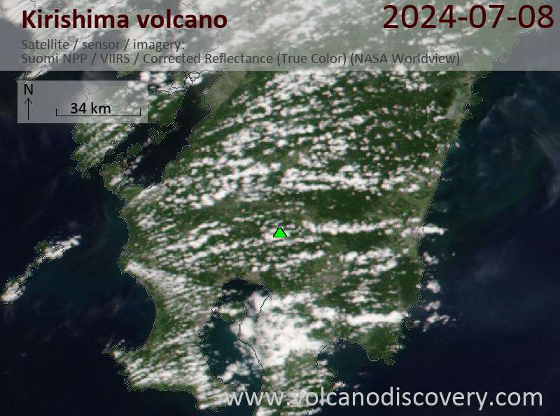
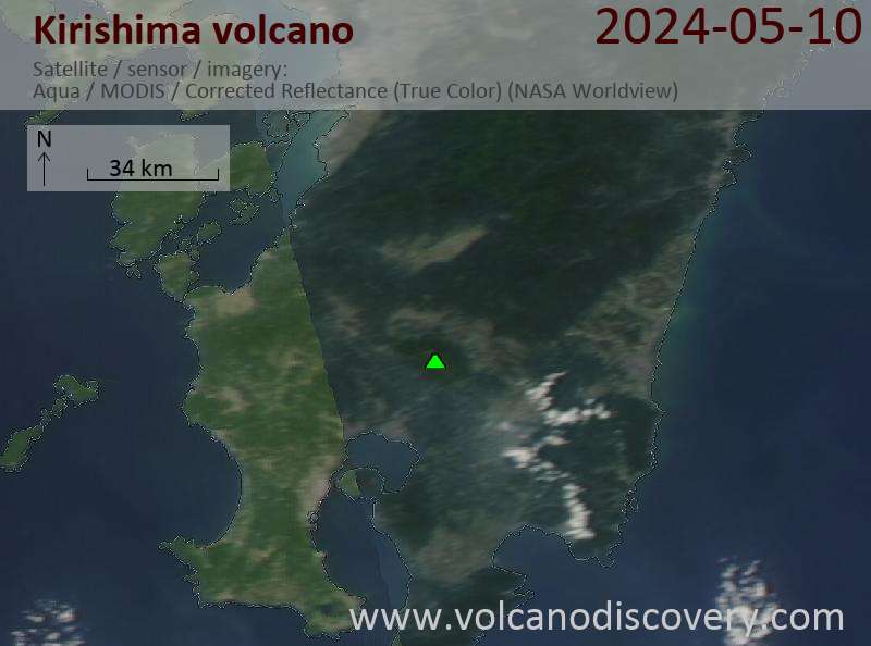
Últimas imágenes satelitales
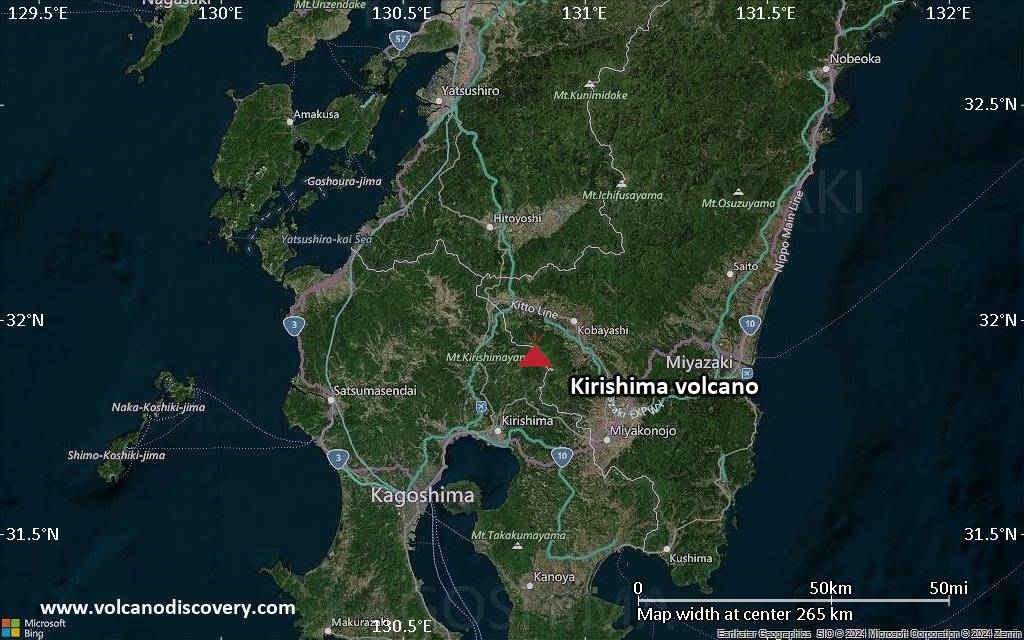
Kirishima Volcán Mapas